Horse Camp Canyon
Angeles National Forest
For Pacific Crest Hikers heading south, Horse Camp Canyon is their introduction to Angeles National Forest. Conversely, for the majority heading north, it is the very last gasp. For me, it is an afternoon hike for until I stop and turn, but would be a good way to hike Liebre Mountain with a bit more time.
 |
|---|
| Entering Angeles National Forest on the Pacific Crest Trail. |
The trail is generally flat and there is only a screen of trees between me and the road at first. This is not so bad as it is a seldom traveled road. The trail is somewhat overgrown, but not difficult to follow. It meets another trailhead just before starting to climb. The climb stays generally in a small canyon east of Horse Camp Canyon and quickly gains views over the San Andres rift zone and the valley beyond. It is less often overgrown and sometimes quite wide along here.
 |
|---|
| At the second trailhead, there is a sign with mileages that need at least another 50% added on. |
 |
|---|
| Looking northwest over the rift zone. |
 |
|---|
| Looking back over the climb. |
The hike is pleasant enough and cool enough, being on the north slope. As I am turning a corner to drop into the little canyon again, I see a ball of gold, almost orange, jump behind a bush. It is across the canyon, but that is less than 100 feet. I take a couple more steps forward and see nothing more from by the bush. I start to walk and the animal decides that since it is on the trail, its hiding spot will be compromised soon and it takes off at a deliberate, but not particularly fast run, long tail straight behind it. I can see the feet hitting the ground, but still cannot hear a noise from it. It looks like it is probably immature, but I may just be misjudging the distance. I spend a while debating if this should be the end of the hike, but while it is my first time seeing a mountain lion without bars, it is almost certainly not the first time one has seen me. I kick myself for debating grabbing the camera too long to get a photo and continue on, sure I have seen the last of a cat that wants nothing to do with me.
 |
|---|
| Tehachapi and La Liebre in the Spring. |
 |
|---|
| Dirty pictures of beetles in the Spring. |
The trail seems to come to a top as it straightens out for a moment. A sign shows I have gotten to Horse Camp. Behind it is a table and another sign for a spring 0.2 miles down the hill somewhere. Past this, another sign informs me that I have gotten 0.5 miles closer to Bear Camp in the last 2-2.5 miles. It might be more trustworthy than the first.
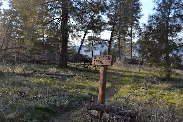 |
|---|
| Horse Camp by the side of the trail. The sign behind the table directs the hiker to the spring down the hill. There is a well defined trail beside it. |
The trail is flat and dropping for a short way, then starts up more switchbacks. There are more and more trees as I climb. There is abundant evidence of somewhat recent fire, but the trail is nearly clear of fallen trees. As the sun starts to set, it seems well into time to turn around.
 |
|---|
| Trees and grass along this flat as more climb looms ahead. Liebre Mountain should be a bump on the right. |
 |
|---|
| The blaze of cloud as the sun gets low behind the mountain. |
I am as far as a forest with a carpet of miner's lettuce below it when I turn to return. I head down, trying not to look like a cat toy, poles at the ready as if they could help me if the cat decides to show in its traditional hunting time. As expected, the glimpses of cat between bushes across the small canyon were the only sighting.
©2015 Valerie Norton
Posted 24 March 2015
Liked this? Interesting? Click the three bars at the top left for the menu to read more or subscribe!


Comments