Munson Spring from Chorro Grande
Los Padres National Forest
Click for map.
When I first hiked up Chorro Grande, I found myself crossing a road and as I climbed further I noticed it was quite obvious and fairly clear and generally not falling off the mountain. I checked my map and there it was. The far east side stops near a spot that simply says "spring". Ever since, I have been meaning to check it out. Years passed, a fire burned the lower section closing it shortly, another couple years passed. It is certainly about time that I actually did it. Not only that, it seems like a while since I have done something exploratory. I did get disheartened when I saw a geocache log saying it would be a long time before anyone followed that road again, but there is an easy plan B to be had: just stop by the Ortega benchmark and try to work up from there. So now, I am once again at the bottom of Chorro Grande, but only meaning to go up halfway.
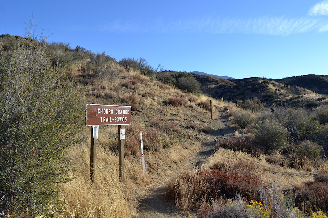
The trail looks pretty good for something that got hit by fire. They do not seem to have closed it for very long, so it would have continued to have feet on it. That generally helps as long as the feet are good about staying on the trail. There is quickly a section with a bit too much slope, but then it settles back down again and stays nearly flat. Where there is brush, it creeps in from the sides, but nothing is difficult to pass. It is the same trail it always was minus the few things that were slightly taller than myself.


A stand of poodledog seems to be gearing up for another season producing seeds that will lie in wait for the next fire. I carefully avoid the two plants invading the trail. I do not know if it affects me, but it sounds rather awful and I would rather not experience the rash it can cause. There are a few scattered plants past the initial group, but then it is back to the more benign plants of the chaparral. The creek bed ahead offers up a bit more green, but no sign of water. Actually, the green does look to be dying away a bit, but that could just be fall color coming on.
There seems to have been some thrashing about as the trail crosses through the willows. Some hikers have missed its continuation on the left as they get to the far side and stumbled up a steep bank instead. Hiding in among the willows are roses. I do not remember roses on this trail. They are unmistakable with big red hips and plenty of thorny potential to grab and hold. The trail climbs out to where it stays drier then passes a random ice can stove and heads down again over a section that looks like it was used for fuel break. If it was, it did not work. Further up the hill, it looks like there is a fuel break that was not necessary.

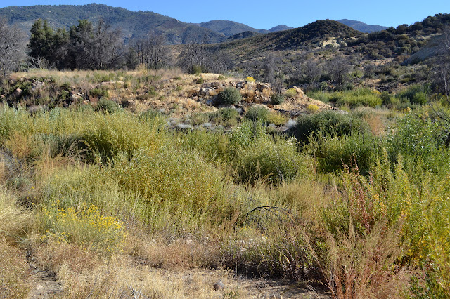
Travel through a large flat area is generally by rut. I brush past a lot of tall, dry grass and am rather happy I did not come up in tick season this time. There seems to be a little braiding going on through it, but mostly there is one trail. One deep rut trail. The vegetation changes noticeably as the signs of fire vanish. There are a couple pine trees, then some oaks, then Oak Camp. It looks desperately dry today.

An obvious gate lies beside the trail on the way up. Past it, an obvious road starts to climb up to the right. Well, that might help explain what the gate was for. I turn for the road because that is my destination. It looks extra brushy just ahead of me, which is not a good sign. It climbs past on my right and there is a good trail covered in deer tracks climbing up to meet it, so I decide to follow the deer.

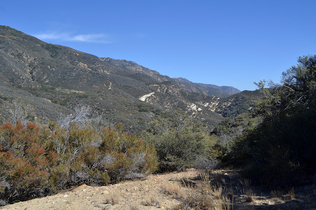
Following the road around, it passes a cut with loads of gypsum showing. Past that, there is a wide and shallow depression. The road seems to pass a little further only to vanish at the edge of a gully. There is no sign of it on the other side, unless you count way up the hill. It is very unclear how this would get there, though. I walk back a little to a better view out and compare it to the topo map. This just does not seem to be quite the right place. I am too close to the stubby flat valley below. I look back at the mass of gypsum. I have been told the road up here were to support gypsum mining that never quite got underway. This could be just some random spur to a prospect. This is not my road.

It seems worth it to continue on looking for another road. This should be one with road heading off in both directions and not like this last one where no road to the west was visible unless it followed the trail. There seems to be nothing even as the trail turns to more serious climbing. It seems a bit far when I look back and see my road. Following it down with my eyes, I can see it getting into a flat area just before the serious climb. The road on the other side is also coming down to this area, but is a little harder to sort out exactly were. Since I could not actually see the wide, flat remnant of the road as it crosses the wider flat of the valley, I plot a route that should put me on the road as it becomes more clear on the side of the hill, then head back down to execute the plan.

Small trails cross the valley in the direction I am going. I pick one and follow it and gradually the road resolves itself as it climbs. It is clear that deer and bear both follow it frequently enough. Some coyote too. Deer were the most recent users. Where the animal trails match, there is a spot where I can scrunch up and push through relatively easily. The bears keep the lower level open and the deer keep the upper level not exactly open, but soft for the pushing. They do not always use the same trail and I crawl through a couple short bear tunnels. The deer trails have too much bramble down low to navigate. Mostly, it is a wide open stroll.


I am feeling a lot better about my chances of actually getting to the spring after seeing the heavy animal trails and that the clear sections really are quite clear. Still, the GPS says it is 1.7 miles to the spring. At a guess, the way this road wiggles through the canyons, that will probably be something like 3 miles of walking. A lot can happen in three miles of unmaintained road. The first thing that happens is it opens up into a flattened area. There are two dug out depressions on the side and trails go everywhere. There is a lot of area up here to explore. One trail is much more heavily used than the rest, so I stick to it. As the flat gets wider, I begin to suspect that somewhere there is a map that marks this as a heliport.

At the top of a rise, I get the distinct impression that it is the end of travel for casual explorers of this road. It just looks vaguely trampled and the trail following seems somewhat less used. Have they no maps? Do they not know it says "spring" over there? Just a little viewpoint and they turn back satisfied, or at least satiated of whatever curiosity drove them this far.

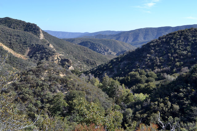
As I drop into the next canyon, which is really just another fork of Chorro Grande, I can see the road still looking clear on the other side, but I fret about what it will be like in the middle. The middle of canyons have a way of collecting water and water has a way of making things grow. It does get a little more brushy as I go down. Something seems to be reflecting in the bottom of the canyon. I pass by another gypsum deposit, but there seems to have been no interest in this one.
There is a bit more to push through as I get to the more sheltered east slope, but it is fairly open at the bottom. The shiny thing is a fiberglass water catch for wildlife that has filled with silt from the creek. Irrigation hose crosses my path coming from somewhere further up the canyon. There is a really good path along it as it climbs. It looks in good order. Should I turn back? It is probably going somewhere lower and not where I am going, I reason. Or, more accurately, hope.
The hose defies my hope by following along the road with me. It has been cut several times with a knife, so is not in good order after all. It stays with me as I climb around to a second branch of this fork and finally stops in a pit dug in the side of the road. Cut wood pieces on the side are the right size to roof the hole and a tarp too small to line it sits in the bottom. More hose drops down the hill from the hole.

I am glad to leave the hose behind and get back to wondering more important things like what is that clear road cut coming up the side of the canyon ahead? I am sure it is not part of my path, which should be popping over the side of the canyon. Maybe it is another way out? (Searching the satellite photos later will suggest it is a long spur to another gypsum prospect or mine.) It looks a little more brushy, but still usable for hiking.
The next canyon is Burro Creek and again, I can see the road cut looking clear as it climbs up the other side. More immediately, I can see the road vanish for about 20 feet. The last traveler through here was a hunter coming up the other direction. Well, it is getting near deer season, but I am being presumptuous. It could well be another fool hiker or a pot farmer. Whatever, a single set of deep footprints crosses the soft sand where there should be road and traveled in the opposite direction. I move slowly and carefully as I progress. It is not the soft sand that is difficult, but the hard packed edges that must be navigated to get to the sand. The steep sand slide of at least 60 feet is not a lot of help. My heart is pounding and my limbs beginning to shake as I navigate the hard packed edge on the other side. Adrenaline is not helping either.
Past that, there is more soft sandy bits on the road, but they are all kindly not going anywhere. A beautiful seed pod catches my eye and I realize it is a Matilija poppy. There was a prickly poppy down by the trail, a thing so full of spines that it looked to be in competition with the wild roses except it was nowhere near them. As I look around, I see them everywhere, all perfectly devoid of spines and holding aloft beautiful seed pods.

The brush gets thicker in the sheltered eastern slopes again, but the road is solid. As I push through one bit of brush, there is a nasty stab to the back of my shoulder. The next few steps, there seems to be a suspicious airiness near my shoulder blade. I put my hand back and yes, I have just ripped a large hole in my favorite tech shirt. Why would I be wearing my favorite? Because it is also my oldest and has proven itself to be a tough thing. I am not regretful that I wore it, but a bit annoyed I forgot the long sleeves I was going to pull on over it for the possible brush. My arms would have liked that, too.

At least the road stays solid except for a little erosion as it crosses the dry creek. The road up comes quickly, except it is not the right road. There is a spur that climbs a bit and then loses itself in the creek bed. The map does show a much longer section following the creek. I head down again. The road gets into the creek and out again, but does not seem all that hard to follow as it does so. I almost miss it as it turns to climb a side canyon, but the general suspicion that now is the right time to be looking for a turn saves me.

As I climb, I notice that the last traveler on this section was bear. The big paws have worn a smooth line along the road bed and where the dirt is soft, there are prints. They do not look all that big. Somehow it gives me confidence that I will get to the spring area. Mister Bear will surely take me there. There is a fuel break at the top that looks more traveled than the road and this dampens my spirits again. I push through thicker vegetation and even have to break up a long dead branch that has fallen across the trail. Still, there was a bear sized hole in the brittle twigs before I got to work at it. There is still hope. Remember mister bear.

The road works out onto a shoulder of ridge and the exposed section is nice and open again. As I round a nice viewpoint, there is irrigation hose again. It drops off the side there and follows the road as I go down. As I get to the bottom, the hose continues upward. As far as the map is concerned, this is where the road ends. There is a break from erosion, but there is more road on the other side and it is easy to get to. Above, it looked like there was a bit climbing again, but that does not interest me. I follow it down toward the point marked "spring" on the GPS which was taken from the map.
Then there it is. Or at least something. A dark bit of dirt that shines in the sunlight. Mud! It is all I was expecting if there was actually a running spring here. Chorro Grande Spring, considered so reliable and a short distance away, has been dry recently.

Success! But is there more? Below, there are a few cottonwoods covered in vines. Signs of a bit of water. Around the brush hanging over the mud, there is a bit of a path, so I follow it. To my left is a small, but beautiful stream.

It looks like I may be able to work my way upward on the other side, so I cross and give it a try. It does not work out all that well. Still, the spring is clearly further up. I can catch glimpses of more flow and hear it here and there. The fight is too much. Crossing back over, I try to move uphill a little but there is even more to prevent it here. There is water flowing on both sides of me. I follow a little path on the other side to find a pool surrounded by grass.

The pond is not that wide, but it is clear. I can see blue reflecting off a few spots a couple feet down on the bottom. Look at all that glorious water! After a while looking, I go looking around again. Below the pool, there is some particularly fat irrigation hose. Of course. A trail leads downward, but it is not all that well established and there are plenty of roses. It would be shorter to try to go down the canyon and return to the car along the road, but it is not something I want to try today. Instead I take note of the oddities of the rocks around the spring and start back the way I came.

I keep on climbing. It does not seem as long now that I know how it goes. The brush does not seem to pull as hard at me now that I have pushed through it once. As I get to the bottom of Burro Creek, I decide to investigate why I was able to almost miss the turn. As suspected, there is road continuing down. This I might try going down. Without all the water from the spring, the plants are not so thick and this road, or at least bulldozer track, hints at another mildly clear route. It certainly starts out that way. I could avoid that bit where the road is gone, too. It should come out near the Burro benchmark which is just a mile away according to my GPS. I head down, quickly coming to (you guessed it, I bet) more irrigation hose. We would not want Burro to feel left out.

Trail goes out into the creek bed, but I keep to the road which becomes impassible. Right. Backtrack and follow the trail. Across the creek, there is a little spot of pooling water which has a bit of a stink to it. I step over and continue on the trail downward as it crosses back over to rejoin the road. It looks to me like bear and humans use this trail, but where they use different routes the bear trail is a lot clearer. Still, there are footprints on it. This must go through to somewhere, otherwise how would there be footsteps above leading only one direction? I stall a moment as the road might split. It looks like bear continues down along the creek, but humans go... up a very short but steep rise. I give the little climb a try to be rewarded by a very clear route in the sun.

The road turns downward again and then everything is blocked by yucca. This is not the first yucca, but all that previously was small and looks like it stays that way until it matures, seeds, and dies. There was space between the spines. This is reaching all the way into other yucca and threatening me with its bayonets. I can see where the deer go through, stepping through the yucca, but not where people go through. I try various advances, but nothing works out. I decide it is probably best to head back. There is actually another route going down more steeply, still on some sort of track. I could try this. Heading down it, there are footprints, or at least fragments, here and there. Unfortunately, there is quite a bit more growth down there, too. There seem to be multiple trails, but none are very promising. It is starting to look hard to travel and the GPS still says 0.7 miles to the Burro benchmark.

Footprints or no footprints, this is starting to look like too much. It may be long, but I should go with what I know. The footprints probably knew the way since they were able to put together a loop. At some point, it will be late enough that turning back will be difficult too. I especially want to be across the slide before dark. I turn back and this time stick to it.

Recrossing the lost piece of road is not so bad. I try to keep myself calm on the way and it mostly works until the very end when a manzanita on the edge tries to push me back. I usually point to the land and sun as the things most trying to kill me in the wilderness, but maybe I should add plants to that. The rest is straightforward enough.

The sky puts on a nice show for me as I go. By the time I am back to the large flattened area, the horizon seems to be a thick, blood red color while above has turned yellow. As I work my way down the last quarter mile, it is dark enough to get out a light. I turn it on and instantly everything seems more confusing instead of less. I keep having to backtrack a little and try again. Eventually something works, and I am back to the trail somehow missing the two bear tunnels.
It is much easier once on trail. I can actually turn off my light again until the trees close in around me near the camp. Past the camp, the ditches are no trouble to navigate except when there is a spot that water actually manages to get out of them, or perhaps the trail finally steps out of the creek. Those spots could be easy to miss and I almost do once. Out in the burn, there is a bird calling and getting answered by something that is definitely not the same sort of bird. The answer actually sounds like a variation of the squeaks mountain lions will make to communicate.
I start rolling down the hill a little more determinedly. I remind myself to remember that there is poodledog invading the trail. It seems longer now that it is dark. I am practically down by the time the first car zooms past to show where the road is. Finally there is a reflection from my car in the light as I am 30 feet from it. Oh, right, the poodledog. I never even saw it on the way down. I sure hope I avoided it. The truth is, I have no idea. That might take away from the high of success. I actually got to the spring! And there was a spring! With actual flowing water! Oh, such lovely water.
©2017 Valerie Norton
Posted 12 October 2017
Liked this? Interesting? Click the three bars at the top left for the menu to read more or subscribe!


Comments