San Jacinto Peak
San Bernardino National Forest
Mount San Jacinto State Park
August 1992
 Camp Mountain Meadows, up near Isabella Lake, had a wonderful backpacking program, but I had already gone there for two of their backpacking units. Probably as a change of pace, I decided to try out a new camp. Camp Tautona should have a good program as it was one of the many organizational camps on the north side of San Gorgonio with access to the wilderness in a drive of approximately 5 minutes. There were only four of is at first and we were collected in with the CIT unit for general stuff since they were our age. There were an even dozen of them. They were given an option to join up with us and we got two or three more from that.
The camp was different from the others I had been to. We had concrete platforms with roofs that we could put the metal cots on in bad weather, but would usually had them out under the stars. At Mountain Meadows we only had our backpacking equipment and at Tecuya we were told to bring tarps to throw over ourselves if it rained, so that was fancy. We had bears in camp because the trash was not well kept. (They were working on it.) Dinning was outside and we were to be careful not to drop anything down through the deck because bears would come. (See, they really were working on it.) Dining was a bit more like the boys camp we stopped at at the end of the hike out of Forks of the Kern, except we had a leisurely hour. After eating, the dishes all got washed and slid into a drying bin that was dipped in rinse water and then in bleach and then set into a wooden bin along the back of the kitchen to dry. And then they got locked up because bears. At the other camps, we brought out clean dishes and sent back dirty ones, so that was less fancy.
We probably learned some map reading and compass work. We definitely hiked around a bit with our packs weighed down with kitchen supplies. I more remember learning a working rain song on the wide steps up to the deck where we would sit and sing camp songs until the kitchen was ready. That had real consequences whereas I had already learned my way around a map and compass. It definitely worked. At least the whole camp singing it with glee was answered by a bright blue sky collecting a few clouds right at the end. Consequences. Singing later was answered with a few puffy clouds turning dark and starting to look threatening and it kept building to rain. We moved our beds in under the roofs that night. I already knew that I could, once in a while, snore sufficiently to wake the dead, but that next morning when my throat felt rather like I should believe the accusations being leveled at me, I learned that it can be very difficult to wake me. With the close quarters, quite a nasty consequence for my neighbors.
The next night was the night before leaving. We slept in the smaller indoor dining space for some reason. We might have been getting up early to leave and did not want to disturb the CIT girls when we got up or we might have just wanted to make sure our gear stayed dry before heading out into the wilds. Oh, and I tried sleeping on my stomach to try to prevent my snotty nose from becoming a disturbance to all again because someone had said they had heard side sleeping and especially stomach sleeping prevents snoring. It worked, beginning a campaign to learn to sleep on anything but my back.
In the morning, we packed into a big van and headed out not to San Gorgonio next door but over to San Jacinto. Specifically, we headed for Fuller Ridge, the north side of the Pacific Crest Trail (PCT) as it passes by the mountain.

Click for general location.
As best as I can recall, this was a four day trip. I figure that because I distinctly remember three camp sites although where exactly the second one was I am not certain. Unfortunately, the photographs are at least a little out of order and someone tossed out the film so I cannot use that to sort them. (The last one was in the middle of a bunch of big water from an entirely different trip after going to Monterey. I suspect those are from the following spring break when we had exchange students, so the film had plenty of time sitting exposed in the camera. There is no Instagram filter being used here, this is all the natural patina of abused film shot with a Vivitar point and shoot.)
Day 1
The plan was to hike Fuller Ridge to Little Round Valley. We arrived with no fuss at the trailhead to start down the PCT. While I had known the John Muir Trail (JMT) as a ~3 week extravaganza by this time, this may well have been the point when I noticed the PCT existed outside of the Sierra and was actually a rather long trail stretching from Mexico to Canada. It was some time in high school that I realized this and that there were a few people each year who hiked the entire length in one go. There were 33 people who completed it in 1992 and recorded their effort with the PCTA. I wanted to do all of the JMT at this time. Perhaps it was Fuller Ridge that helped snuff out any spark of desire to do the PCT from end to end.
We climbed for a bit and then we dropped for a bit and then climbed and then dropped. Mostly what I remember of Fuller Ridge is that it would not let us settle into a climbing gear or a downhill gear. The map suggests my memory may be exaggerating the changes, but I remember a lot of changes. I especially remember it seemed to anticipate when we were getting into an uphill rhythm and that was when it would turn down again. I also remember that the camp was not entirely clear on the idea of "vegetarian" and I was supplied beef jerky for lunching, so Fuller Ridge was my first and only time having a bit of that. It was tough to eat, but palatable enough. (I also had a hamburger at camp which was awful. One of the other girls heard that I did not eat meat and came up with this gem: "Isn't that tasteless?" I guess she did not know where spices came from.) You would think the beef jerky would be the largest memory of the day, but it is more of an "oh, yeah" as I poke through the memories. The lasting memory of the day was that Fuller Ridge is a hard hike.

As tough as it was for the rest of us, there was one girl who was having a really hard time. As we climbed, her stomach was rebelling. Food definitely would not stay down and then neither did water. This being a classic sign of altitude sickness and altitude sickness being surprisingly dangerous and the only cure for it being going down, our trip probably should have stopped there. As it was, she was determined she could go on and the counselors were willing to let her, so we continued. She kept on trying to keep hydrated, which took a lot more water than predicted, but we found a couple streams on the way up to refill from. That first one, probably the one coming from Little Round Valley, was very good in its timing.

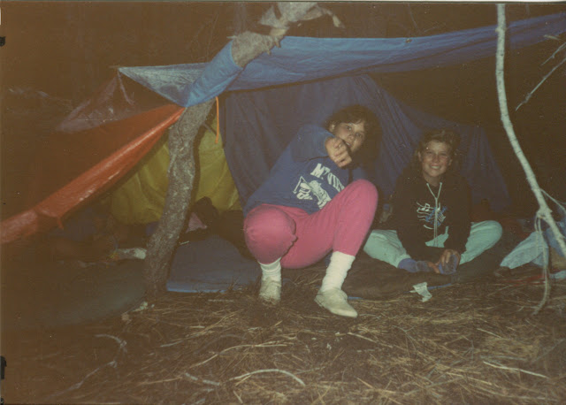
We got to the junction with Deer Springs Trail quite late. It was clear it would be dark before we got up to camp. I think there was some discussion of stopping early but there was some reason we should not. (State Park rules of camping only in designated camp sites could be it.) Anyway, we continued up with darkness falling on the way. We were exhausted when we got there. Still, we found the biffy and the water and had some supper. This may have been a Mountain House experience, another thing that is not common to my hiking. It was neither horrible or good enough to feature in memory, if it was. Oh, and the one girl was feeling better. We set our sleeping bags out under the stars and got the food hung in a couple of the stuff sacks and tucked in under. The stars were amazing and the dark sky was ever so slightly deep purple around those bright spots. Although my memory is horrible for color, this is one I always remember.
Day 2
We all slept amazingly well. Right through the bit of rain, as it turned out. I woke up with it misting. There was a circle of ice where water had pooled on my sleeping bag over my chest. (Training myself to never sleep on my back took a lot of years.) I was surprised the old sleeping bag I was in was still capable of keeping me warm in that much chill. I did not take long to be surprised, though. Getting ourselves into rain gear and everything packed up before it could get any wetter was a priority. We got packed up really quickly. We expected that rain song got sung again. Our fellow campers could be so heartless!

We were still able to have a bit of breakfast and then got moving up the mountain. This slog was not so bad. It just wiggles upward in the trees. Then we heard thunder. Truth be told, it was probably quite close thunder. Hiking stopped as those wiggles upward are to the peak. We took careful note of the trees around us. We could see scars on many of them from lightning. Our external frame packs, big aluminum lightning rods, were placed in a pile to the side and covered with tarps to keep them dry and then we found a nice spot near, but not too near, trees without so much lightning scar to wait out the storm huddled under another tarp or poncho.

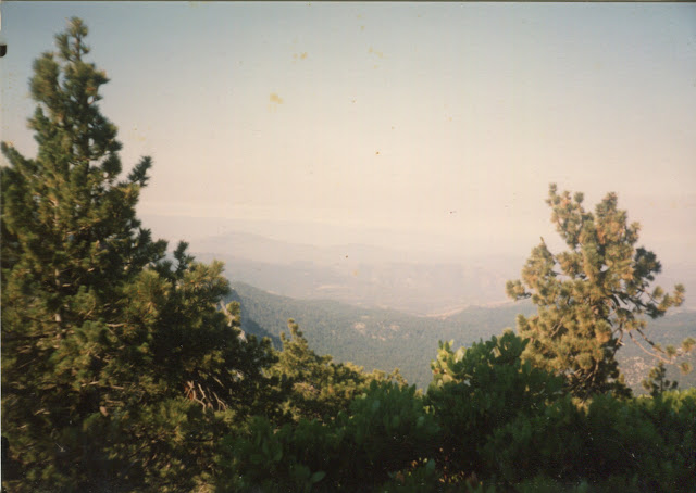
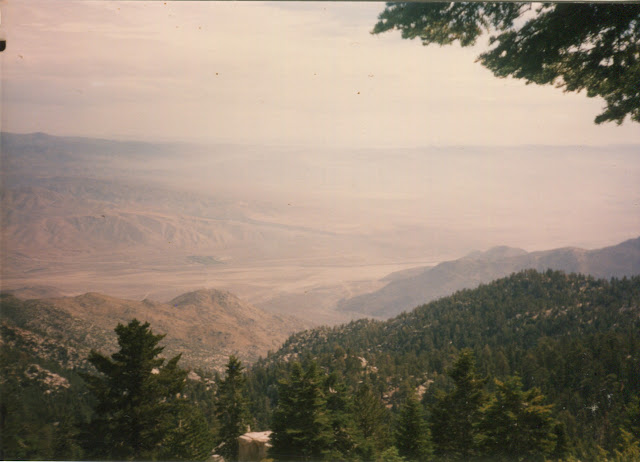
We talked, told stories, learned a song about Minnie the Mermaid (it is bawdy), and a couple of us watched the lightning. I certainly did and thought it was amazing. A few others did not even want to hear about it. Not the long strikes as it stretched all the way down to the valley far below us and not even the much shorter strikes as it moved onto the next mountain. Even as it was over there, we still did not move. Even as the strikes were all behind it, we had to sit and wait. Eventually there had not been any thunder for a good long time and we could start again for the top. When we got there, the counselors said that if they had known we were so close, they probably would have taken us down before waiting it out. We had been about 2/3 of the way up the trail from camp to the peak.

Still cloudy and drizzly, but audibly calm, we headed up to the junction and then to the peak. Most the climbing is done by the junction. I think we checked out the cabin, but it may have been closed. I am fairly certain we had the mountain to ourselves.


Then again, there may have been someone to ask if we came by the tram. We would have asked what they were talking about because we had no idea about any tram. We came by trail, that is how these things work.

We headed down to camp. I remember one reason we were not worried about waiting a while was that we were having a short day and most of it would be downhill. In this case, short was about 4.5 miles. Maybe we headed out extra miles from the loop to where there are campgrounds, maybe we did not. Our actual camp site was a somewhat round clearing maybe 100 feet in diameter and surrounded by big trees. There was no biffy there. Instead we designated a particularly large tree at the edge for use with solid waste requiring a much longer walk in another direction followed by a bit of digging.
Day 3
I am pretty sure things were dry again for the third day. In fact, it was a bit too dry. We must have had water near camp, because water was not a worry at the start of the day. As we hiked out toward our last camp, we found no more. Maybe all that rain had not hit that side of the mountain. We got around to Strawberry Junction, which is a short hike from anywhere we might have camped the night before, and started plotting. We did not want to continue on without getting more water. Our counselors were carrying extra jugs of the stuff, so we had some to camp with, but barely enough. It was decided we would bail out on Deer Springs Trail, which comes up at the junction, in the morning instead of continuing on to wherever we were originally planned to go out. I am fairly certain that was something other than Fuller Ridge again, but can not remember. Marion Mountain looks like the most likely trail out other than Deer Springs and that is not much longer than the bail route.

So we lounged about on the rocks all afternoon and sipped very little water. Someone had a the setup to turn their Thermorest into a chair. At some point I tried the chicken noodle soup mix and someone accused me of making fun of them when I actually tried to chew the rubbery chicken substance in the Cup-a-Soup. I am not certain how that would work. Anyway, the chicken is as indestructible as chewing gum, it must be said.
Day 4
We headed down the 4 miles or so to the road and got our ride informed of the new pickup point and headed on back to camp. We probably hurried a bit to try to get them informed before they left to pick us up. Things worked out.

August 1998
Or maybe it was 1999? It could have been September too. Or July. There is surprisingly little memory of this one. Honestly, I might have dismissed my second trip up the mountain as a figment of my imagination except that I confirmed something on the third trip that I could not have learned on the first. (Of course, my memory of the first is not the best either, but why would we have bailed for lack of water if we found water?) It was probably with my little sister and probably when we were both undergraduates. The fact that I was in charge should have left more memory, but apparently not. I remember going to the ranger station in Idyllwild for a permit. Er, it was across the street from that restaurant, you know the one? We learned there was "no water" up there. None at all. We would have to bring it all.I am fairly certain there was a couple mile drive down the highway to get to our entry/exit. We probably used Marion Mountain, which is the short way up. On the first day, there was definitely no water. On the second day, there was water. The first was around the edge of the mountain as the trail came down. The first is around Wellmens Cienega, but it is really just a muddy patch along the trail. Gathering water would be very hard. The second is about a quarter mile past Strawberry Junction where the thinnest stream trickles down the rocks. Strawberry Cienega was dry, at least near the trail.
And past that, I have not even the clue of a recollection of what happened on the trip. Four figments of stopping in the ranger station, a short drive, and two places to find water. Maybe it is all my imagination.
Ju** 2003
I was going to say August again just to keep it going, but it was probably earlier than that. Hortie (whose name probably is not spelled like that) had a plan to hike the mountain as was inviting Shachi's friends along. Aamod went. Sony probably did, he was always up for a big hike. Mandar, Kaushik, Sundeep, Ravi? Shachi sure would not go today, but might have been on it. We were about six strong, so a few of those definitely did not go.Anyway, Hortie had a plan. We would hike up to the loop trail that goes over the mountain and camp out there. We would do this along the shortest route possible, namely Deer Springs to Strawberry Junction. (This is not the shortest possible, but State Park camping rules might have come into the equation, in which case it was the shortest route to an allowed camp.) The following day, we would do the whole loop as a day hike. The day after, we would hike out and head on home. There was difficulty, though. It was the same story as before, there is no water on the mountain. We would have to hump up the trail with all the water we needed to camp two nights and hike one long and somewhat warm day hike. Also, the 11 (or was it 13) mile loop sounded like an awful long day hike to me. Still, I was game.
Day 1
Just a matter of getting there and climbing up to camp. Easy! Well, we probably inched along with all our water. It was probably somewhat familiar. It was very familiar when we got to camp. I declared I had camped there before and the biffy was right over there. It was. It might not have been the same one, but it was right where I remembered it. I said there also might actually be water a quarter mile down the trail to the left, but we were set with water and did not explore that. Anyway, we would be there tomorrow.
Day 2
A bit of breakfast and a bit of packing up was all that was needed to get started. In 2002, I had entered the modern era of backpacking, if that is determined by the purchase of an internal frame pack. It was a massive pack that I have never been able to fill, but it lacked all the pockets that I had no idea what I would do with anyway. This made it come in almost two pounds lighter than the rest in the store, at a little over five pounds. It was tough as nails and would probably put up with five years straight in the backcountry. It had a removable top that could be used as a fanny pack that I would finally test out for our day hike. I packed in a little food and two Platypus bags and maybe a windbreaker. You know, the real essentials. It was really heavy for a hip belt, but the 4 inch wide strap, even unpadded, made it okay. The water bags sort of do their own padding by conforming, too.
We headed out clockwise. Shachi told me much more recently that this is the lucky direction and you should always go clockwise. It is an Indian thing. Undoubtedly, this is why we did. It does not explain the other two clockwise preambles, so maybe there are other reasons too. In about a quarter of a mile, there was the thinnest stream of water falling over the rocks beside the trail.
San Jacinto is full of new things. Somewhere short of Little Round Valley, someone let me have half a Clif bar for the first time. It was probably Hortie. He had been bragging, if that is the right word, that he could live on about three Clif bars a day and little else for a week. Aamod probably had a few too, but he would have been far ahead of me. I was actually given a whole one, but the thing was so disgustingly sweet (not to mention generally disgusting) that I could not go on after the first half.
It was about then that I was noticing some rather nasty back pain. This probably marks my first use of "vitamin I" for hiking as well. I might have had it in my bag or gotten some. One way or another, I got an ibuprofen to calm the back pain and it worked well.
And then there was the first at the mountain. Those last few feet gave me some slight altitude sickness. I got sick to my stomach as I hit those rocks just past the junction for the summit trail. It was not something I was going to let change my route, but I did take the rocks very slowly. It would not be a happy day to fall off of any of those boulders you have to climb through to get to the top and I was feeling like I just might.
I still had a good look around. It was over a much greater area than the first look around, but similar to the second. We probably checked out the cabin at the top. Eventually, I carefully moved back down to the junction, which made me feel better again. I had finished off one bag of water about the time I got to the top of the mountain, so the fanny pack was not feeling quite so overweight as I headed down. That back pain probably still needed anther dose of pain killer. And so we slid back down the mountain to camp.
Day 3
We had prepared sufficiently as far as water goes and no one needed to hustle over to the trickle to get more, so another day where we just need to eat and pack up and head out. Which we did. Quite successfully. My back did not hurt at all with the pack. Since then, I have found that any hiking without a stiff backpack leads to back pain in just a few miles, but a pack with a stay keeps me nearly pain free.
©2017 Valerie Norton
Posted 8 October 2017
Liked this? Interesting? Click the three bars at the top left for the menu to read more or subscribe!


Comments