Rubio Canyon
Angeles National Forest
Locate the trailhead.Rubio canyon is a particularly short hike heading out from a street corner on a right-of-way between houses. Just up Lake, then onto Palm Ln. to Maiden Ln. (which sort of merges in), then through a slew of roads all named Rubio to find a trail up a tiny canyon with many, many waterfalls. It used to have a few more, but the water company dropped a few tons of rocks on most of them a couple decades ago. A few years ago, Mother Nature dropped 11 inches of rain on the mess in less than a day which the rocks couldn't hold. The large falls were uncovered, but the lower small falls are still invisible.
 |
|---|
| The trail heads out from a neighborhood corner. Decorated with a warning sign thanks to the local water company. A great little hike if you can ever get the boy off the phone. |
Once we got the boy off the phone, we got started down a rather warm trail along a rather south facing slope. The first half of the trail continued along this slope with one tough spot.
 |
|---|
| Fairly flat trail heading up the left side of the northeast heading canyon. The first half of the trail was mostly like this. |
Artifacts can be seen along the way, but there is really very little left of the old resort that stood here around 100 years ago. There are more going up the hill, but they are hard to see from this point. They can be seen from further up the canyon.
 |
|---|
| The base support for the lodge that once stood here as a resort for the rich and idle. There seems to be quite a lot of this stuff in the nearby mountains. |
After this, the trail ducked around the iron pipes which are themselves about 100 years old, but still in use, and dropped into the canyon floor. This is where the loose rock that didn't end up in the flood control dam at the end has stopped. Somewhere here there was a lake used to generate electricity and a few little falls. A fairly passable path through the rubble can be found since many have been passing this way, but one must still be careful of ankle twists. Hsin-Yi managed to hurt hers a bit.
 |
|---|
| The character of the second half of the trail is a bit different. Small, loose rocks cover the bottom of the canyon now. Broken pipes have simply been left in many places. Other pipes are still in use and repaired with PVC. |
The strewn rocks bring us to our apparent destination, the first waterfall along the canyon. The paper we picked up at the trailhead noted there were more waterfalls along the way, or would have if I hadn't misplaced it somewhere along the way. There is just a dribble of water coming down the rocks.
 |
|---|
| Moss Grotto (top) and Ribbon Rock (bottom) falls: The first waterfall is a meager dribble and the first water we've seen along the way. Some of our fellow travelers along the trail chose to climb up the first half, which was quite an easy climb. |
We proceeded up the canyon to the right because we remembered that there was a suggestion on the paper map that that was the right way to see more waterfalls. The trail kept going up the bottom of the sharp little canyon and forked. We took the side instead of going up further. One short segment of this trail was quite frightening, but we made it past and found ourselves at the top of the falls, which we couldn't have climbed to.
 |
|---|
| Moss Grotto (center) and Ribbon Rock (upper left) falls: The top of the falls in the picture above. Just below is the place the other people were climbing to and far below that is the current bottom of this waterfall that is still somewhat buried in the loose rocks dropped off the mountain by the water company. Such a very small bit of water going over the side. |
 |
|---|
| Above, there are more falls. Here, a cascade isn't particularly cascaded over, with a second cascade and pool beyond it. Hidden but close enough to be heard is another waterfall. |
 |
|---|
| What little water there was did its best to fill in all the areas of the narrow channel. It flows thinly over the rocks here. |
We climbed up the little cascades in search of the dribbling sound behind them. We came to a rounded chamber in the canyon along one side of which was a very dribbly waterfall whose drops falling loudly due to the amplification of the chamber. We had lunch among the "thundering" dribbles.
 |
|---|
| Lower section of Grand Chasm falls: A very dribbly waterfall about 20 feet high spilling into an echo chamber along the narrow canyon. The pools are always lovely. |
 |
|---|
| Lower section of Grand Chasm falls: A little disorienting, but you can see how much the canyon hugs in around this waterfall a little, as well as an idea of the depth and steepness of this narrow cut canyon. |
Looking back, there's a smoggy day to behold.
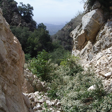 |
|---|
| There's a smoggy city out there somewhere at the end of the canyon. Although the walls twist and turn, we quickly climb enough to look over the short walls. This is the view from the cascades. |
There appears to be a route to the top of the falls, and therefore to perhaps more falls, via the loose rocks to the right while looking out like above. There's even a little ditch that looks like it's the commonly traveled area. No one felt they wanted to take on that hike, though. We turned back and braved the scary bit again.
 |
|---|
| Ribbon Rock falls: Back to the first waterfall. Now that it's abandoned by other people, we take a closer look. The rocks are lovely with their dark lines on otherwise light grey stone. |
Then there's nothing to do but to hike back out.
 |
|---|
| And then we're back. I can see all the way to Glendale! |
 |
|---|
| And now you know where you are. |
Your hapless hikers are:
 |
 |
 |
 |
|---|---|---|---|
| Abbie | Mingshr | Valerie | Hsin-Yi |
There are two main pages I am using to identify the waterfalls. Mainly a page by a guy who knows the falls in their former glory, post debris dump, and post big debris movement. He's put together a nice page kept up to date. Secondarily, a page by a guy who gives a post debris drop, pre massive debris movement, post smaller debris movement account that's rather hard to follow and links to other pages that don't exest anymore for pictures. This one, however, adds a cheat sheet listing the falls and describes how to get to the top of the largest falls instead of the bottom for the hearty rapeller coming from Echo Mountain. The missing page is nice for its account of hiking when the dammage was the worst.
© 2007,2008 Valerie Norton
Posted 13 April 2008
Updated 26 April 2008
Liked this? Interesting? Click the three bars at the top left for the menu to read more or subscribe!


Comments