Echo Mountain and Inspiration Point
Angeles National Forest
Locate the trailhead.Echo Mountain is the most popular local trek. Easy to find at the top of Lake, the other main street after Colorado in Pasadena. Even on weekdays, it can be a little bit crowded so on this gorgeous and warm, but not too warm, winter Sunday saw a veritable highway of people going up and down. The trail heads up 2.7 miles to the mountain and then three trails split off from there to go further up. I took the third one that you come to in the space of 50 yards just before getting to the location of the ruins of the old hotel and trains.
The trail itself is mostly out in the open on a southerly slope with some amount of westerly slope visits. It can be quite hot in the summer, especially in the afternoon. Of course, on a clear day this affords rather grand views of the city. On a very clear day, there's even ocean out there to be seen. This was a very very clear day.
 |
|---|
| A clear day in Los Angeles. The shinny thing is the Pacific Ocean, of course. Past the point on the left is Catalina Island, a scant 75 miles away. Altadena and Pasadena in the foreground. A little Eagle Rock and the Hollywood hills further on. Downtown LA in the center sticking out of the flat sprawl all around it as usual. A little of Glendale can be picked out. All sorts of other cities, some of which are really just LA by another name, can also be seen. |
The trail climbs steadily up the edge of Los Flores Canyon wrapping around to Rubio Canyon, the peak being between these two. It's well maintained and, like I said, well traveled. The wide, fairly smooth trail bed has no tough spots to get through except if it's too hot to be hiking in which case the lack of shade can be quite tough.
 |
|---|
| Los Flores Canyon on the way up to Echo Mountain from Lake Ave. The surrounding country is a bit green although water hasn't been plentiful yet. |
There have been a couple good rains this year. Though not enough to make the waterfalls impressive they do seem to have been enough to green up the surrounding hillsides nicely.
 |
|---|
| The view off to the west and a little north in the early afternoon. Really the view along the edge of the mountain range. The 210 can be seen in the distance cresting a low point as it heads to Castaic. |
The top of Echo Mountain seems to get closer each time I hike up it.
 |
|---|
| At the top of the ridge seen from Echo Mountain, there is a structure I have wondered what was each time I was there. It turns out this is my destination today, Inspiration Point. 'Point' as in 'point of interest' rather than a pointy bit of land. |
The top of Echo Mountain, which is really only a little peak along the way but apparently my understanding of the use of the words 'peak' and 'mountain' are backwards, was the site of 'White City', a hotel, observatory, small zoo, and novelty trains. One came up the steep incline from Rubio Canyon to provide access to the resort and another wound around up here for sight-seeing. The foundation and the abandoned iron remain today.
 |
|---|
| Some wheels now locked down to the narrow gauge track they used to travel along. The track is getting a little buried in the dust. They've got a cute little lizard on them. |
 |
|---|
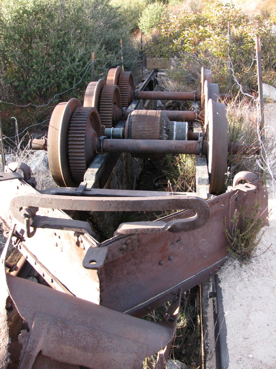
| The huge gears and wheels that were involved in bringing people up from the canyon below. The wheel in front grips the cable to pull it along. |
 |
|---|
| The first artifact one sees is actually this engine set over a space that would allow working under it. It would need a lot of work now to get it to run. |
I had never actually proceeded further along after getting to Echo Mountain and was determined to do so this time. From here, two trails continue up and one goes to another piece of city but looks at this point to also be going up. The first two coming up to Echo Mountain roughly follow the old sight seeing route around the nearby peaks. I took the one closest to the mountain instead, since that one promised the shortest route.
 |
|---|
| This lesser used trail curving away under a tree. Having trees is a nice improvement over the lower section of this trail. |
The trail was much narrower but still well traveled and well maintained. There are a few tough spots near the top, but otherwise a very fine trail. It takes a route along the upper edge of Rubio Canyon starting off flat then climbing a fair bit. Parts of it were well shaded and it looked like it would be much better protected from heat on any given day. Of course, my day was starting to cool off by the time I started up it anyway.
 |
|---|
| The top of one of the water falls in Rubio Canyon. Not much of the many huge waterfalls of the canyon can be seen as this was all I spotted. Marred slightly by the pipe stealing water from further up before it can ever be tossed over these high falls. |
 |
|---|
| Another waterfall along the trail, this one quite dry, found high up another canyon. |
The trail finds some small tributary canyon to wind its way up. When it gets to the water, the area is especially cool and wooded and probably nice even on a somewhat hot day.
 |
|---|
| A small creek with just a little bit of water in it. |
Along the way, there are some good views of Echo Mountain and the ruins and the flow of humanity that comes to it.
 |
|---|
| Echo Mountain with a group of people clustered around the 'echo phone' and another at the top of the steps to the hotel checking out the city views. The late afternoon is making the visibility not look so great. |
As the sun was setting as I finished my climb. It actually set when I was about 1/4 mile from the top, but that last bit of the climb was quite easy. The moment the sun set, the winds kicked up. Guess there's a reason they're called 'sundowners', among other things. The valley stretched below me in tones of orange.
 |
|---|
| Some sunset colors with the sun peaking through some trees along the side of the trail. |
 |
|---|
| Near the top, trees and rocks colored by the sun setting. These trees make it look like it might not usually get too terribly hot up here during the year. |
 |
|---|
| Sunset over Catalina as the lights come on in the inland valley. |
Without too much trouble in the stiff wind, I made it to the pavilion that was constructed at the top of the ridge. It just took a little fleece to keep me warm enough. The pavilion has picnic tables and tubes for siting various landmarks like the Hollywood hills, the islands, and various cities.
 |
|---|
| The pavilion, built almost 100 years ago but mostly rebuilt to stand today. |
Here (as well as at Echo Mountain), I took a moment to draw. I ducked out of the wind by the wall to look out over the city. In the failing light, it got quite hard to see what I was doing.
Since this was a destination for the railway so long ago, more of the old narrow gauge rail cars have been put here for people to see the history. From here, another railroad went along the ridge pulled by a mule and called the 'One Man One Mule', or OMOM, railroad. I'm not really certain why this is a fascinating fact, but everyone seems to point it out.
 |
|---|
| The wheels and track near the pavilion. I doubt this is in its original location so is more illustrative than fact. |
 |
|---|
| This may be tucked away on a ridge at the back of some canyon, but there really is a large view of the valley below. Here is the view, the pavilion, and the somewhat silly sign they've got stuck on it. The sign is probably historic although this one is unlikely to be the original. |
 |
|---|
| Cue voice over: "This is the city...". I give you a few 1000 square miles of city sprawl. It may look like all one city, but that's not even all one county. In the dark at the bottom are the sighting tubes. |
Done drawing until it was way to dark to look at the lighted cityscape and still be able to see my paper and done using up the batteries of the camera on a couple last flash photographs, I headed down remembering to fish out my lamp a few steps on my way. Annoyingly, the lamp decided it didn't really want to work and the process of getting my pack back on my back managed to knock the bite valve off my hydration tube, a thing I didn't notice until 3/4 mile along because my pack wasn't packed so tightly as to squeeze the bottle. Navigation by the residual twilight and the city glow of all that sprawl proved to be rather simple even on the one spot I'd thought would be a little difficult without a light. I did still have my camera and phone, both low on battery, to shine a light if one was particularly needed.
Coming back in the dark, I still occasionally heard the voices of people screaming into the echo phone to eventually hear a low echo. The echo comes from rather far back in the canyon so it's a few seconds before you hear anything of it by which time there's usually someone talking saying it doesn't work. When I got down to the mountain again, I found a great crowd of people having snacks and waiting for the full moon to rise. It rose in just a few minutes.
 |
|---|
| The full moon rising as seen from Echo Mountain. None of these pictures really turned out as far as the moon is concerned, but at least you can see a couple stars and the hill silhouette. |
The rest of the hike was even easier, although my feet did start to get sore with all the downhill. The total hike was probably nearly 10 miles long. It all worked out rather well since I keep feeling tempted to try one of the Y's full moon hikes which do just what the group I met were doing, but on a smaller scale of about eight people rather than dozens.
©2009 Valerie Norton
Posted 17 January 2009
Liked this? Interesting? Click the three bars at the top left for the menu to read more or subscribe!


Comments