Angeles National Forest
Locate the trailhead.
The desire to see how Arroyo Seco has fared after the fire got the better of me and I had to go see. I think this is the first time back since that first hike with sketchbook in hand. Most of the trail is not, strictly speaking, open to the public. Much earlier along than the actual closure, the city had put up a road block to be annoying. Perhaps the city has closed the park between the city and the forest as well, but they didn't actually put up any informative signs about that. Usually they remember to try reason with you about how it's such a bad idea and threaten fines. These signs were just shouting "No! Not allowed!" which doesn't convince anyone who's already decided to go into the forbidden zone.
Many other people were also ignoring the signs. Maybe not as many as would usually be found there without the signs, but plenty of people. Dog walkers and joggers as well as hikers. I even saw a few runners up past the first water crossing. They were wearing no socks in their soaked but not water retaining shoes. Not that you can really tell if a runner is wearing no socks. Anyway, I took off up the paved road that starts off the trail, noticed that it was sloping downward more than I expected, took a more careful look around and realized it was the road to JPL, and backtracked back up the hill to the correct road that starts off the trail.
 |
| The fire ravaged hillsides and saved homes behind La Canada-Flintridge. The hlls and fire breaks are showing a little bit of green as the annuals come up in the spring. |
The first tributary along, a somewhat large one, marked a sudden change in the quality of the roadway. Much debris had come down it in the couple of heavy rains we've had. It was deposited all over the road above the bridge but had been cleared a bit to allow cars to pass. Along the other side of the road, the main creek had undermined the bed significantly. Soon a debris strewn bridge over the main creek brought the road to the other side.
 |
| A look at the somewhat swollen creek in an area where it has been somewhat tamed. |
Most the bridges were intact. I think the bridge that was lost a few years ago to high water and was supposed to be rebuilt last year still was out but at least they'd stopped claiming the trail was closed due to that. Perhaps they just haven't replaced those signs after closing the trail more decidedly.
 |
| A concrete barrier washed up in the flood plane. It's just another big stone to the river. Also quite a stacking of logs behind the trees. |
 |
| There seems to be a new layer of grit flattening out the banks of the creek within the canyon. The trees no longer bulge a bit near the ground and there are few rocks in sight. |
The road becomes dirt and splits and the lower side passes some Forest Service housing about the time it enters the forest. Past that, it ends. Before the bridge went out, it was passable with a trailer all the way up to a campground about two miles up, where the host had a trailer. Now it comes to a dropoff of about four feet where the erosion during flood stopped, for now. There's no bridge, but I can't now remember if there was or if it was a ford. Before, there were always rocks or trunks to cross where there was no bridge. Sometimes it was a challenge, but you could go the entire trail without getting your shoes wet, although that metric probably applies to somewhat lower water levels. At this level, you should still be able to go without getting your feet wet in waterproof boots. I had waterproof boots but could only see the lack of any big rocks on the bank and the gritty water. I just had to step in and hope. Something about all that smooth outside the water made me think there was just smooth inside the water too. This worked, but it was higher than my boots and a little water came in the top, slowed only by my nylon hiking pants.
 |
| Lots of nothing to cross on but very little to trip over either at the end of the road that once passed quite clearly through here and further up. |
|
From there, I just picked my way along the river bed. It used to be choked with growth, so this would have been difficult but now all the little things had been removed by the flooding and debris. Sometimes I saw the road, but would have had to cross the water to get to it so continued on as before. Sometimes I found the road on my side and so had an easy time of it. The tributaries had cut in deeply here and there so that not all of the road was easy to pass.
 |
| A bridge that is standing just fine in spite of clearly being down in the flow at one point. The road is nearly out going to it, though. |
 |
| The tributary through this cleft had cut deeply into the road making a challenging, though dry, crossing. The hills are a nice ash color and the tallest bushes are dark, burned twigs, but much is growing and blooming. |
New growth was everywhere, though. The hillsides are still ash colored, but popping out with purple and yellow. Although the yellow is actually a parasitic thing and not a sign of hope. Little raspberries were coming up in the higher places where they weren't completely destroyed. Eventually I did come to places where the fire came down to the water, though.
 |
| A few burned trees. They still stand even through the torrents that must have been difficult to stand against, particularly in their condition. The center one looks a bit more than charred. |
 |
| What's left of the old hunt club, but this was a casualty long ago. |
Up at the campground, everything was still looking untouched. It had been closed since the first bridge went out leaving only one way out for the campground host with his trailer. That was nice, since his trailer smelled worse than the biffys used by the campers. Next to the campground is one of these water level gauges.
 |
| The creek flowing over the well worn concrete steps that help indicate how high it is. |
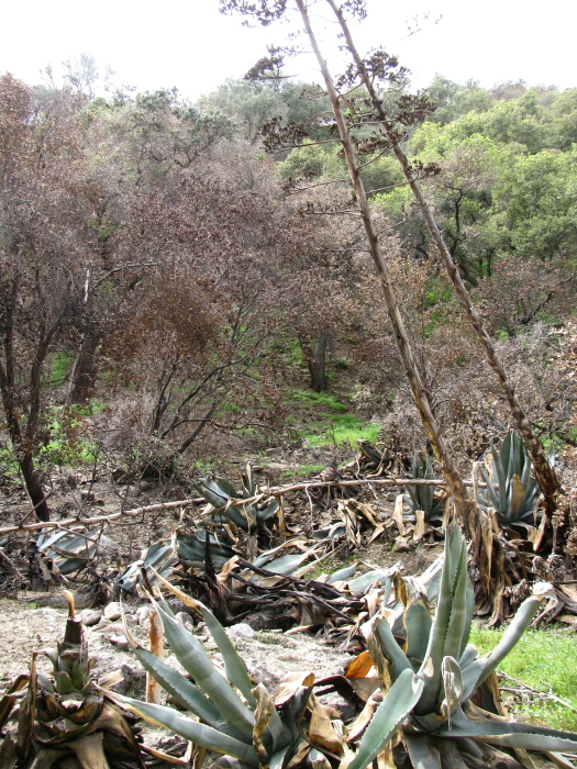 |
| The stand of century plants near the campground and the trees behind got some spot singing, but not much harm came to them. |
This section was doing a good job of following the most recent road. I won't say old road because there are places where you can find a bit of older road that the current one doesn't touch. The hillsides are singed at the top, but otherwise even the creekbed is looking alright until what was once a thick and solid wooden bridge that is now space.
 |
| Just a little off the top. |
 |
| Some of that curiously flattened stream bed. |
 |
| It's rather amazing how well this one has been removed by the flames. Maybe it was treated wood. Someone's put a fence up to keep the hikers from using the girders as a bridge. |
 |
| The footbridge that marks the last bridge and the last recently driveable section was licked by the tongues of flame, but they don't seem to have taken hold. Both sides had a few blackened boards from the unimportant sections of the bridge. This spot would be quite difficult to navigate without some sort of bridge. |
The trail continued on with these random spots of destruction, but still as a trail. A section of it goes high and away from the creek for a short stretch leaving a hill between the track and the water.
 |
| A little stand of pineapples... er, yucca. Singed at the bottom and back to the growing thing like nothing happened. |
 |
| Some of the trees look to have had the dirt yanked from them and some look just a little bit more buried. |
Finally, I got up to Paul Little picnic area. The fire had been there. The trail used to go mainly up from there, but was hard to find except for going into the picnic area. As I looked up the hill, I found some of it. It will need some repair work. It doesn't look like anyone has been that way, maybe they all think they'll be too saddened to go as well. The camp site at the top was a lovely little spot. For now the trail and the evidence of recent passage all goes into the picnic area.
 |
| The pit was gutted. Someone seems to have decided to store a ladder in there later. It's wooden and unsinged, so it couldn't have been there while the rest burned. |
From the picnic area, the dam is not so far along the creek. The (once) main trail climbs up the side of the canyon to get above this. It's the end of the road otherwise. A very tall, sheer wall. Perhaps it has a little more curve to it than I claimed before. It didn't stink this time either. It gets called a debris dam and is more full of rock than of water on the other side. Trees are growing out of the stuff behind it.
 |
| The dirty water cascading over the edge of the dam just above Paul Little picnic area. Oozing and leaking and spilling with large trees hanging over the side. |
 |
| A taste of the forest that grows out of the debris. |
 |
| Some kids I bumped into just before Paul Little was visible and who wondered how far it might be. They pulled out a huge cigar to smoke by the dam because that's what you do when you're surrounded by fire devastation, I guess. Actually, they were getting misted by the falls where they are and there's not a lot to try to catch fire. They provide a little scale for the thing. |
 |
| Way up high just under the spillway, the year (1942) is stamped into the dam. |
 |
| Climbing around of course gives new viewpoints to the falling water. |
Of course, eventually it's time to go back.
 |
| Some more burned bushes and new growth coming up among them. |
 |
| An example of how well we can do erosion out here, sometimes. A crack high up the hillside shows the mountain side has slid down a few feet. |
 |
| Some new growth in the form of some wildflowers. |
Coming down, I tried even harder not to end up crossing the creek. I'm not sure I succeeded, but I did find myself on the other side of the creek from the one I'd come up on from time to time. There's a few old gardens from long gone cabins along the way.
 |
| A couple palms standing in what was likely once someone's yard, just a bit singed. |
 |
| A tree along the way with it's roots plunging down a crack in the cliff side to help it perch on the edge. |
 |
| A little bit of leftover equipment. A bit of firefighting hose that became cut and lost at some point, now wrapped around a tree trunk by the flooding. |
 |
| Although these are singed, I don't thing they're the result of the fire. They're just funny. Some downed wired left down show this is no longer in any use. |
 |
| Now back to that first crossing, looking at it from the other side. This is just past the ranger housing and it looks like they've abandoned an old building close to the cliff. |
 |
| Not too far up the way, I sat in some grass to sketch the foundation of a ruined cabin, itself not in very great shape. |
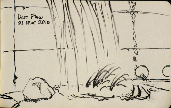 |
| Up at the dam, I sketched a bit of the water coming into the pool from high above. |
©2010 Valerie Norton
Posted 16 May 2010
Comments