Cave of Munits and Castle Peak
Upper Las Virgenes Canyon Open Space Preserve
El Escorpion Park
Click for map.
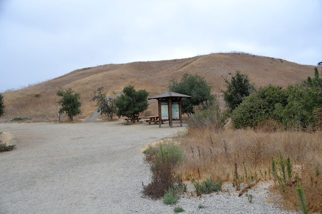
I expected it to be a little warm today, but there is a thick, grey blanket overhead keeping things cool. Victory Trailhead is not the closest to the cave and is the only one with a parking fee, but it comes with some signs and picnic tables and a truly disgusting bathroom. It claims to be open sunrise to sunset and has sufficient gating to make it difficult to pass should those get closed. I was able to save the $3 by parking along the nearby street which probably added a quarter mile to the start. Most seem to do this while some go ahead and pay the minor fee.
Starting off, there are a lot of trails to choose from, but only one heading north toward the cave. I turn right to follow it up a short way and then down a long and gentle path. There are many small use trails off to the side going up canyons or ridges. The cave comes into view quickly as the largest of numerous vertical dark spaces in the rocks further north.


Continuing in a northerly direction, there is another junction of trails. It is not hard to pick the one going toward the cave. Somehow, while there was hardly anyone on the trails before, there is suddenly a crowd all going my way now. A couple small groups are already there and a large family outing seems to be coming up behind me. The overhanging clouds are managing a very light mist.


I wait a while for the numerous kids to pass, figuring that it will be a more pleasant experience if I give them the time to climb through first. There is another little group behind them. It really is a climb up into the cave and through it, requiring handholds and footholds along the way. My long abused camera gets a couple more hard knocks on the way up. There is plenty of room to move even with a pack on.


The cave is carved out of a conglomerate rock and quite large for the area. It offers many handholds that rip ever so slightly at the skin. It closes in a little then opens up into a large chimney area. Behind that is another large room that narrows down to nothing. A small chimney may be developing in it, too, but for now it is just a higher spot in the ceiling. There is a clear and well used path continuing upward out the chimney. I poke around a bit and then follow it to the top.


Trail continues steeply up to the ridge above and I follow it. At the top, it continues along to the right to the highest rock outcrop above the cave. Except for the outcrop itself, the ridge like track is easy to walk.

Trails lead down to Castle Peak further down the ridge. These follow a little smarter route avoiding little outcrops and bumps along the way. Again, it is a piece of conglomerate, so handholds to climb up it are plentiful but painful.


I head back the way I came, then continue westward into the less touched hills of the old movie ranch. Somewhere out there, "Gone with the Wind" was filmed along with many others. There are a couple trails along the north side of the ridge line. I just take one that will go out that way (west) a bit before turning south ending up on the one closer to the ridge.


My trail starts to turn east, so I take a lesser trail along an old bit of road west instead. It turns out to be lesser because the old road is completely eroded away toward the end and difficult to get down the last few feet.

With a little work, I connect up with a main east-west trail and head west again. This comes to another hill and splits up, so I choose the south route along a canyon. This trail looks official enough at first, but then it starts to seem unmaintained. After that, there are a couple spots that seem unbuilt as it hops steeply up the side to avoid growth down the center. Following that, the trail seems to just give up on the canyon altogether and climb steeply up the west side. I really seem to be choosing these trails badly.

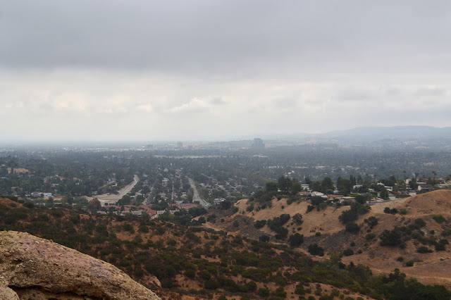
Up at the top, there is definitely an official trail. It even has a bicyclist and a few walkers on it. The hills stretch for miles to the south and west under a clearing sky.

Up here, navigation is easy south and then east back to the original trailhead. There are a couple different ways and I do manage to take the one that is less direct and maybe less interesting. I still get there.

©2017 Valerie Norton
Posted 23 September 2017
Liked this? Interesting? Click the three bars at the top left for the menu to read more or subscribe!


Comments