Will Thrall Peak and Pleasant View Ridge
Angeles National Forest
San Gabriel Mountains National Monument
Click for map.
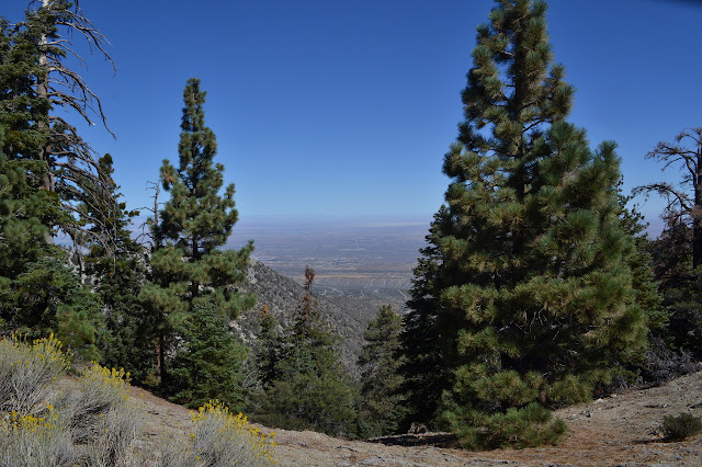
A new day and new peaks to bag, but this time I will join a planned outing of the Hundred Peaks Section for some company. I have been really wanting to do the traverse of Pleasant View Ridge from Burkhart Saddle to the other side of the closed bit of the Pacific Crest Trail, especially if there is going to be a car shuttle. Unfortunately, this is not that. This is heading up to the saddle and then turning the other way to grab a couple nearby peaks. Still, it gets me into an area I have enjoyed visiting before, then out to some new spots. First, it is a little over a mile downhill on well used trail to Cooper Canyon, past various falls and with the sun thinking about getting down into the depths of the canyon.

Past the Cooper Canyon waterfall that marks the end of previous exhibitions in this direction, the trail just drifts downward above the creek. Eventually it gets down and crosses water is flowing the wrong way. We were following down the creek, but suddenly we have been going up the creek. It is just Little Rock Creek after Cooper Canyon joined it not too long before. On the far side, a slapstick with a PCT crest points up the creek along a deteriorated trail. It follows Rattlesnake Trail past Rattlesnake Spring, which has been temporarily closed for since Dec. 2005 to protect mountain yellow-legged frogs. The Forest Service teases us with plans of this opening again, but the current Williamson Rock Area Closure Order goes until Dec. 31, 2018. The rock climbers seem to be the most disappointed by the ongoing closure as Williamson Rock is apparently an absolutely lovely piece of granite with all levels of exciting routes up it. It is probably a rather low point in the PCT hiker experience as well. We have hit our lowest point in a more literal way and start to climb continuing on Burkhart Trail. There is something a bit nuts about the canyon we slowly pass by.

We hike deep into the folds of the mountain as we climb, sometimes in the wrong direction. At one ridge, some discuss the route up to Goodykoontz Peak. It is a steep and crumbling mess. I wonder why they would want to go up that and get told that it is better than coming down it. I have to give them that. That is for next week. One crease looks like it was once a good place for cedar trees, but the large shapes stand dead now. A change in water or passing of fire? I am suspicious it is the first although the second would not have helped. We keep on climbing to the saddle and new views.
Burkhart Saddle was an innocent player in it all, but it cannot help but remind me of my most egregious navigational error ever. I will be quite happy if it stays my worst moment in navigation. From here, the easy hiking is finished. It is time to head off trail and get on with the climbing. No navigation challenges are involved here as today is a day of following. Besides that, there is a very well established use trail going our way.
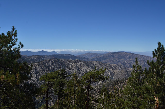

After a steep climb, our track levels off for a much easier walk up the last few feet to the top of Will Thrall Peak. It has a plaque telling about Will Thrall and a beaten up register box. Judging by the reactions of my companions, the beating on the register was recent. Around us, the view just keeps on getting better.

Not yet satisfied, we continue down the other side of the peak to head up to a slightly taller one. The use trail we were following keeps on going too. It seems obvious that it must be going to the higher peak, too, until we find ourselves wrapping around to the far side of it. We leave it to whatever it is going after and strike out for the top which is not too much further.


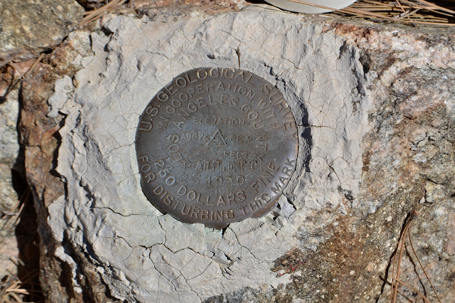
This peak is marked by a benchmark named for Pallett Mountain, just on the other side of Burkhart Saddle. The HPS folks call it Pleasant View Ridge. I think it is the highest point on the ridge that is not already named. Mount Williamson at the southeast end is higher.


One hiker heads off for one more bump further down the ridge while the rest of us turn back to climb back over Will Thrall and down to the trail. Once on trail, we take the time to admire the rather large acorns developing on some of the trees, but mostly just truck on back to the water.


After a little stop at Little Rock Creek, we get a report on the extra peak. It seems the use trail went right out to that one where there was some evidence of an established camp. Specifically, there were pieces of an old stove. Perhaps the rest of us missed out not going on the excursion further down the ridge. Too late now, so we get on with the climb out of the canyon and back to Buckhorn Campground.
©2017 Valerie Norton
Posted 28 September 2017
Liked this? Interesting? Click the three bars at the top left for the menu to read more or subscribe!


Comments