Munch Canyon to Figueroa Mountain returning via Willow Spring
Los Padres National Forest
Click for map.
I seem to be out to "clean up" my climbed peaks on the Hundred Peaks List by making sure any drive ups actually have a climb. To that end, I plotted a climb up Figueroa Mountain. Sure, I will notice a curious lack of climbers on Peakbagger for the peak as I log it because it is not, in fact, on the list, but let us not get confused by the facts. (This seems to be a lesson I am constantly relearning for nearby Zaca Peak, too. These two peaks that sit so prominently in my mind as a Santa Barbara based person just are not that important to those based in Los Angeles. Besides, they are both too short.) Since I just did Davy Brown Trail, I looked to nearby Munch Canyon. Just have to find it. I know there is an old gate at the start and probably nothing else to mark it.

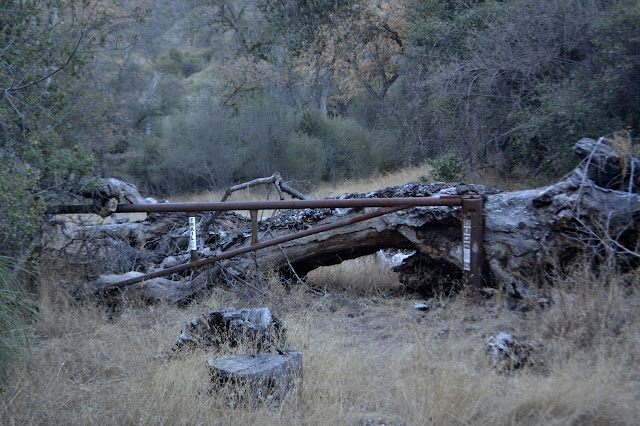
Everything starts off wide and flat, not a canyon at all. Grasses scattered with oak trees and one has dropped a large branch on the trail soon along the way. Some walk around it tightly and some wander all the way to the Sunset Valley Trail as it continues on its gentle path to the left. Another gate, marked with a few trail stickers, blocks the old road. A trail wanders off to the right going who knows where while the one I want heads off along the road some more. It comes to yet another gate set just behind an older gate and now strengthened by a fallen tree. I have never seen so many gates in such a short length. Another unmarked trail heads off to the right through the thick chaparral.
Past the gate, it starts to look a lot more like a canyon. The tree behind the gate is not the only one along the trail. There is a nice, big one shortly after it right along the trail and decaying quite a bit. I would say it has been there a while, but the walk around trail in the soft dirt does not seem all that well established. The recent trail work has me thinking about what the state of the trail is, and so noting the huge, decaying tree trunk instead of just walking along the side of it. Past it, I cross a dry stream bed, but soon after, I can hear the music of water in the canyon below. Water is getting to be an elusive critter even in the winter. One bit flowing, the next bit dry and not even showing underground water by the plants that grow.

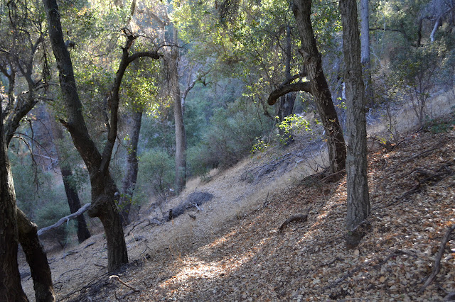
After a little listening to the music, the trail turns and starts to climb. Withing the canyon, it has very little memory of once being a road, but as it climbs, it becomes obvious again. Although a road, it is still quite steep. Erosion cuts across it at one spot leaving only the smallest dirt bridge to cross. It turns back and there is a bit of a view.

There is a spot of rocky meadow and although the trail is not hard to follow, there are slapsticks to show where it goes. It stops looking like old road as it gets up into the upper canyon and Hurricane Deck begins to peek out over the tops of the northern peaks.


There is still the sound of water below, but the canyon side is far too steep to want to explore. There is too much vegetation to see anything down in the shadows until there is not, at which point the canyon bottom is dry and silent. The top is a junction marked by the splintered remains of a wooden sign post. I find myself uncertain of where exactly I am. I should have paid a little more attention to the map. I seem to have only looked at the trail I wanted and skipped noting little things like junctions. Whatever it is, I want to turn right except at the junctions I know, but I think I may have missed one. Spotting an extra trail, I decide to just head out on the fire break. It looks slightly traveled and will give the best view north so far. It is also the only thing I am certain about. It is certainly wrong.


And then it is back to the junction and heading down, wherever that may take me. It is shorter than expected before I am down in Fir Canyon on Davy Brown Trail. I definitely missed a junction. It was probably where the trail was marked when it did not seem to need it. There might have been another trail there, perhaps with a touch of brush stretching over it to help me take it for a game trail rather than what it was. This junction has some signs to help determine where I am, were I not familiar with it already. I do not seem to remember signs here before. One marks the Munch connector I just came down and one marks Willow Spur I was thinking of going up for a figure eight. The moment of feeling mildly lost above makes me decide to head up Davy Brown instead, sticking to what I know.


At the top, I have to grab a moment with the view out to the west to check out the ocean wrapping around the point. Then I turn back to climb up to the road above. This time I really can just turn and climb up until there is no more up.

The initial hill beside the trail turns out to be ridiculously steep. It may look like it has mildly established trails going up it, but that is only because the dirt is so soft that a single passage marks it. Happily, it is a short distance up even if it takes a long time. It flattens out abruptly where there is an old fuel break with trail along it that makes the rest of the travel quite easy all the way to the road. The couple of guys lounging by the road seem to think my appearance via the ridge is remarkable, in that they remark upon it "out of earshot", but not the most unusual sudden human appearance they have witnessed.

They follow me quite slowly up the road because that is where they are going too. I poke around near the interpretive trail and stop for photos of the deck and my trail up, but they never quite catch up. I wander around finding the benchmark and checking out the old lookout a little once there, then find a spot to enjoy the view. There is no good view out toward Zaca Peak from the top although there were a few good spots on the way. I had thought to maybe grab it in a spur, but it just looks like too much road walking once I am there.


I am shortly off again to find my way back down. I expect the north ridge to offer a good route and clearly I am not the only one. The fuel break here has also been maintained as trail by hikers. The brush here would be difficult to push through if it was not. It is steep and hard with loose rocks over the top so requires careful stepping, but does not seem nearly as absurd a route as the start of my route up.


I continue on to the next bump where there is grass all the way from the ridge to the road and even a game trail to follow. Somehow, I really do not see the point in going down there, though. Thinner trail continues along the ridge, so I follow it. Hopefully I will recognize it if my trail crosses in front of me, but I expect it will not.

There are no more trivial bail points to get off the road to the ridge until the road comes around to meet it in a saddle. On the far side of the curve is a little sign marking my trail down. That certainly was easy.

The trail is across a soft hillside, so wanders up and down depending on how it has slumped over the years. It settles down as it tucks in under oaks.
The junction with the spur trail is obvious as I drop into the bottom of the canyon, although marked only by slapsticks. Somewhere around here, there should be a spring. All I can see is an old trough below the junction. It was piped from somewhere else. The area around it looks no wetter than anything else. Lower, there are some raspberries. Above does not quite ring of spring either. I am looking for easier, so continue downhill on the trail instead of taking the spur.


As I continue down the trail, I find I believe in it less and less. The crossings of the dry stream bed are all deep dips. The brush comes in on all sides. The trail itself seems to have altogether too much following the bed directly down the hill. It seems to have its development in people pushing through enough times and not in someone building it. There are some spots that look like they have lost their switchbacks. Maybe there was something built once.

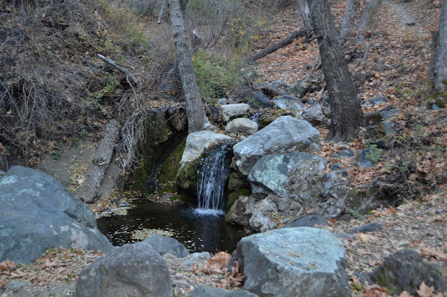
I finally spot some water when almost back down to Davy Brown. The other ones do not say "spring" on them, but they are flowing. Why not this one? Once it does get water, that water is on the trail.

Down at the end of a trail is a nice, big sign I know I did not see before. The rusted patina does not fool me. I know Mike likes to make sure they are rusty before putting them up so they fit in with the old ones better. Besides, I was wondering if both the tracks were actually trails when I was here before, although only one had a marker. The other marker was behind a fallen branch. With the sign, there is no question. I head down the rest of the way to the campground, where there is another sign for the trailhead.

From Davy Brown Campground, Sunset Valley Trail offers a nice, non-road route back to Munch Canyon. It starts at the other end of the campground and does not have a nice, new iron sign to mark it. It is marked, and then crosses the creek to a thin shelf that looks like it is about to fail. After a short follow of the creek, there is a steep climb up to the ridge above and no more creek all the way back.

The trail is the unknown trail heading right at the third gate along Munch Canyon. That solves one mystery. Since there was an unknown trail off it a ways back, there is still mystery. Something to explore next time. I probably said that when I hiked past it last time.
©2017, 2018 Valerie Norton
Posted 7 Jan 2018
Liked this? Interesting? Click the three bars at the top left for the menu to read more or subscribe!


Comments