Agua Tibia: Wild Horse Peak
Cleveland National Forest
Click for map.
DAY 1 | DAY 2 | DAY 3
Researching the Agua Tibia Wilderness, I found it may be a rather tough backpack. Its namesake looks to be very difficult to obtain from anywhere. It looks like my most likely chance is a stream that I will come to while technically outside of the wilderness. There are a couple springs on the map, but they seem rather close to some black squares of buildings. Looking on satellite, there do seem to be a couple of homes next to these possible sources. As if to drive the point home, my permit specifically calls out for the respect of private property in the "special notes" section. That eliminates the best bet. I will have to carry all my water for three days. I have found and filled a total of five Platypus bags to take. One to hike, one to camp, one to hike, one to camp, and one to hike. Camping actually takes less than one and hiking down will not need so much either, but the other two hiking days may require more. The one to hike today goes in the sleeve and the rest fill in all the space around it making a single thick band of water in my pack. With my sleeping bag below, food and a few other camping and warming items above, I have a pack that is a little more than 40 pounds, but 3/4 of it is consumable.
The pack feels like a torrential weight upon my back as I lift it and start, but the slowly rising walk through the campground to the trailhead allows my legs to slowly accept the burden. With the obstacle of water solved (I sure hope), there is still the obstacle of the trails. The two trails up to the ridge above are supposed to be fine for travel, but the connecting route along an old road may be a bit of trouble. Some trail runners through just a couple weeks ago are certain that no one could get through there with a full backpack. Now, I have heard stories of backpackers tying their pack to their ankle with a bit of rope to crawl through a quarter mile of bear tunnel and worse. "Where there is a will, there is a way." I am not quite certain that I am that sort of backpacker. Still, trail runners probably have no real idea what a backpacker can do. (I sure hope.) Someone before them was claiming to have needed to "army crawl" to get through.

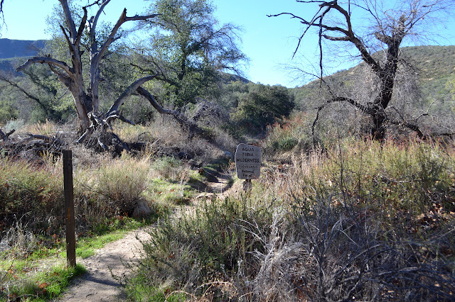
Sorting my gear took longer than I had hoped it would and it is later than I expected to start and already getting warm. There seem to be quite a lot of people also on the trail. As the trail splits and I take the left up Wild Horse Trail, most of them go the other way up Dripping Springs. I see switchbacks for it going up an east facing slope with very short vegetation and suspect it must already be baking up there. My climb seems to be among somewhat taller stuff and soon turns out onto some nice, shady, north facing slope. Whyever would they want the other trail? Well, eventually this one will turn around to the south, but I bet the guy alternately carrying or walking with a toddler is not going all that far. I pass rock gullies and the air coming down each is like air conditioning. Then there are some short exposed bits in the sun, but the trail mostly finds shade. Below is a rocky wash that should be Arroyo Seco Creek in this season. There just has not been enough rain this year although I do see a little wet in the dirt as I climb.


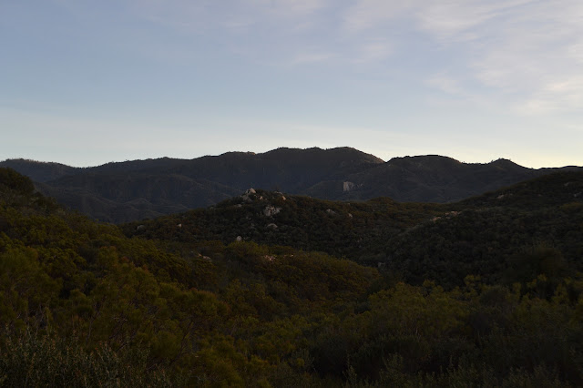
As I climb higher up and around the side of Wild Horse Peak, civilization seems to get a bit closer. Not too distant hills, probably just the other side of SR-79, are covered with a dense network of dirt roads and cities are becoming visible behind it. Just down the hill I stand on, there is first the glimpse, then an overlook of grapes stretching out in neat lines. Thomas Mountain is easy to recognize as it drifts out from behind the near hills because smoke still rises from the controlled burn near its top. It adds its little bit to the murk in the air coming down from the Thomas Fire burn scar.


Gradually, I do have to face the sun in long stretches. There is first a shorter section to help me get used to it, then after a brief bit more with shade available, the trail commits to being in the glaring sun. I am planning to climb Wild Horse Peak. I expect to see a thin marked trail, but have only seen trip reports from people who went up from whatever spot felt doable. The trail wraps around a finger ridge and briefly heads north to a very small saddle and there is a cairn marking a small trail that became a slight mud flow in the last rain leaving a small delta around the cairn. It is cute, but the peak still seems far away. (It does not help that I am focusing on the wrong bump.)
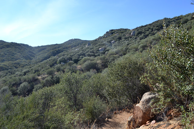
I head up a little more before I decide it is a good time to head upward. After a short climb, I ditch 20 pounds of water and a few other things to make travel easier. I might have dropped it near the trail, but there could always be someone along to help themselves to it and it is MINE, I am WORKING hard for that water. Besides, the trail is a bit thin with no place to stash items. Then I work my way upward. Somewhere in my pack is a tough shirt that is not too uncomfortable in the sun for pushing through the brush on Palomar Magee Trail above and I should take it out to protect my arms except... well, not except. There is no excuse as I deliver quite a few scratches to my arms. The route I work along is not all that bad, really. I drift off to the left, sometimes even losing a little elevation, when there is bad growth above, and then climb again where there is room. Near the top, there seems to be a trail along the ridge. After a saddle, there definitely is with cairns and everything. It takes me directly to the top and a peak register.


And so I take a moment to look around a snack and generally enjoy, well, being there. Even if there does not have much prominence before things start climbing up quite a bit higher.


I think I will follow the trail back down, but seem to not find it after the saddle where I picked it up. I think I have it, but it turns into a wall of brush, so it is a very short attempt. My route was open enough. I just follow my footprints, memory, and a little of the GPS right back down the way I came to pick up my water and gear and continue up the trail a short way to a break off point for the Agua benchmark. Shortly before getting to my gear, a noisy group passes by on the trail. This surprises me because footprints did not seem to be very fresh. I cannot see them at all from where I am. When back down on the trail, their footprints are obvious enough now. Were they doing the whole loop?

The trail up Agua benchmark is well marked by a cairn, but proves a little difficult to discover the initial continuation of. It is rather useful to have because the first part is rather thick brush. I drop my stuff off at a widening along what I initially take for the trail, but cannot quite see how it continues from there. I head down one trail to the side, but it fizzles into thick brush. I look to see if maybe this is not the end of the curve I think should have a trail, but it most certainly is. My wanderings come back to the dropped stuff where making a little more effort to push through some thin brush puts me on an obvious trail marked by cairns and cuts and quite a few recently broken branches. It looks like someone was determined to reopen the trail by hand for a couple hundred feet, then the breakage slows down. This trail is even more harsh on my arms than the bushwhacking I just did, but to stop and get out my protective shirt like a sensible person would slow me down and I am powering forward. Also, it has gotten late and I suspect sunset will not be long after I return to the trail.

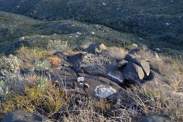
The trail I am on tops out with one minor class 2 scramble to get to a rock with an unmarked post sticking out of it from some surveyor. It is a rather disappointing surveyor mark, but then I look off down the side to a slab of rock with the real mark. Scrambling down to it, it is an Army Corp of Engineers station. A second one with an arrow punched into the triangle was set as a reference mark. That is a little better.
After a fruitless search for the other reference, it is right back down again. I follow trail down from the slab rather than go back over the top. The trail I followed up was not that good after all. I do aim at joining back to it towards the bottom where it was good and end up joining a little too soon. It probably does not matter any anyway. Then it is picking up the gear and 20 pounds of water and continuing up the trail to Crosley Saddle at the top. Considering it really is almost sunset, I am distressingly far from the finish for the day. Actually, I may still have half the trail walking to go. And the hiking water for the day is already getting low.
Nothing for it but to walk. So I do. The brush around the trail reaches out into it more here past the turnoff points for the peaks. None of this makes the trail hard to follow. A post marks the direction I should go as it runs into and starts to follow an old road. It is probably more for people going the other way so they do not miss leaving the road. It looks rather clear heading the other way.


My water runs dry as the old road drops down the side of a small canyon and into some trees. Convenient since I need to dig out my light, too. The good news is, now I only have 20 pounds of water and the bad news is I will be using a bit more than allocated for this part of the trip. I remind myself about the extra for camping and going down again. It will be fine. (I sure hope.) From my brief stopping point, the road continues eastward where it is choked with brush and the trail carves a switchback further down the little canyon. This is the start of a rolling bit as briefly out of the wilderness. The creek bed at the bottom is dry. I stand still for a moment, hoping to hear a little water, but there is nothing. If there was a pool, there might not be anything to hear anyway. As I climb again, I can see a single lone light from the area marked Crosley Homestead on the map. Dropping again, I pass a second dry creek bed. This is the one I most thought might have some water. I stand and listen again, but nothing hints to its presence. Climbing again, the trail is well marked as it crosses the road to the last home in this area. There is a wood block on the far side preventing anyone from driving up the trail as it turns to old road again.

The decaying road makes it easy to continue in the deepening dark as I gulp down the water from the second Platypus bag. As I climb, there are more and more lights. The controlled burn is a distant orange glow and the Anza valley is full of lights spread out all over the place. I am thinking that since it is such a wide road, there are actually quite a lot of places to settle down and camp, should I want to, it shrinks down to trail. This turns out to be a brief situation as it scrambles through a moist saddle. It opens up again soon after.

The moon comes up big in its time. As I continue, I am surrounded by some very tall trees. The land drops steeply down to another creek that could be gurgling with unreachable water this time of year, but not this year. The trees stretch out from far below to far above. I seem to be disturbing roosting birds as I go and one hits up against a distressing number of branches as it takes off in a panic from my light. Maybe I should just set down a camp, but the end is getting quite close. I gulp down more water wishing I could try to represent these trees in a photograph and figuring I am drinking down so much that I probably will get a chance. I must have drunk down at least an extra liter.

There are trees down across the wide trail and they become frequent as I enter burn area. They are all pretty easy to get over or around. I can see dead trees standing above most the route as I continue upwards. This is no longer a usable place to camp. I am a little worried about the saddle as I hear it is "choked with poodledog", but it seems to be a common camping area still. The trees thin toward the top leaving a few safe places to stop. I go the last little bit to the sign marking the end of Wild Horse Trail. I was told there was a site "underneath those two trees, you know?" but it is clear there are no two trees to be underneath up here. There is a flat site directly behind the sign and some less flat ones a little further back. Those might actually be common spots to check out the view beyond where distant city lights are visible. I see no indication of poodledog at all. I go for the flat spot far too close to the trail. No one will be up here for a while come morning and it is a bit more sheltered from errant breezes and, like I said, flatter. Supper! Sleep! It is certainly time. Checking my water, I have definitely gone through every drop that was in some way extra.
Continue to the next day ⇒
©2018 Valerie Norton
Posted 14 Feb 2018
Liked this? Interesting? Click the three bars at the top left for the menu to read more or subscribe!


Comments