Posts

Showing posts with the label HPS+Santa Barbara County

Cuyama Peak

Image
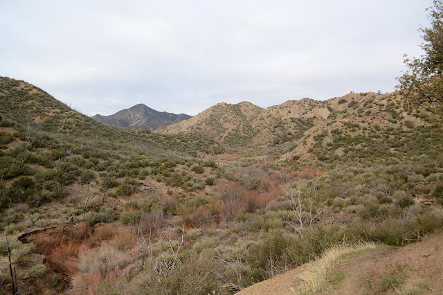
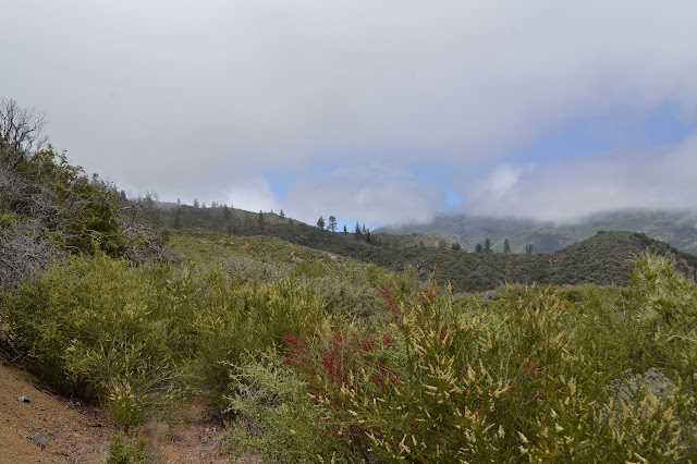
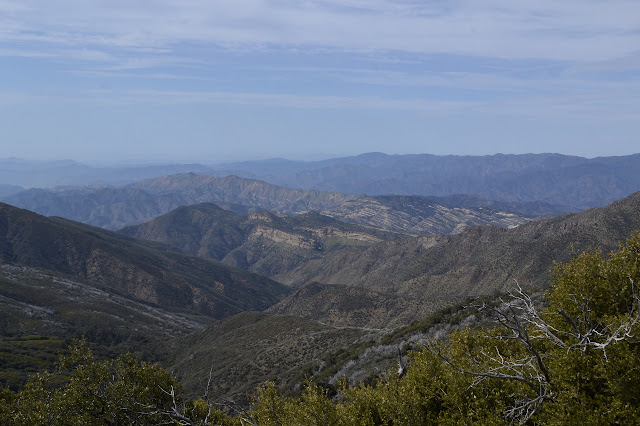
Los Padres National Forest Click for map. The automated weather says today is the brief sunny moment between a couple small storms, or did when I could get a weather report. There are some clouds, but they are clearing. Getting up to the peak is going to be a 12 mile hike if I take trails. I plan to go up using a ridge for a shortcut and come back on the trails, but it will still be a 20+ mile day. If the gate weren't locked, it could be shortened by three miles, but I'm pretty sure my car wouldn't make it across the river so it doesn't really matter that the gate is locked. My arms still hurt from shifting trees on Deal Trail, so I really hope Tinta is not in a similar shape. Starting the same place as for the loop with Deal Trail, but a bit earlier. There's a bit more ice on the unstable log that crosses most of the Cuyama River, but I'm not keen for another spill into the water. It was 24°F earlier and probably hasn't got much warmer yet. ...

McPherson Peak and Peak Mountain

Image
Los Padres National Forest Click for map. Here I am at Aliso Park again staring at McPherson Peak, or into the trees in its direction at least. My undoing! For seven miserable hours. That was a week short of two years ago now. It somehow feels both longer and shorter. I'm going to reverse my path this time. That way the battle that is finding the peak trail will be done in plenty of light. I've already done the initial part and found where the trail starts from the campground. Just past where the trail starts up the hill heading north, you can find the remnant of the old and official route of the road as it goes south up the canyon. It is easier to see as it rejoins the current road than as it passes through the campground. More importantly, where it once crossed the creek, there is a thin line that does not and instead continues north, climbing, along the hill quickly becoming very distinct trail. The trail starts in the southwest corner of the campground. There...

Santa Cruz: Santa Cruz Peak

Image
Los Padres National Forest DAY 1  |  DAY 2  |  DAY 3 Click for map. The morning is thick and grey, but I expect that will be gone by 10AM. It is higher up this today, so I can see actually the land around me. I get to see the outside of the barn now. It is a simple building and not very barn-like. Poking around the rest of the camp areas is nice, but it sets off one volunteer's dog. I like a spot a couple down from the station where a big oak has fallen and now it is nice and open over the table and camping area. Even next to nice big creeks like this one, I am starting to get wary about large oak limbs. I weigh down my camp gear so it stays where I put it and pack up and take off as the others start to fix breakfast, joining the mowed trail by the register and starting to climb along a tributary out to those meadows I saw in the gathering gloom yesterday. On the other side of the canyon, I pick out the trail going the other way, climbing in easy switch...

Big Four finish: Samon Peak

Image
Los Padres National Forest DAY 1  |  DAY 2  |  DAY 3  |  DAY 4 Click for map. Clouds rush in at the first light of the day again, but this time it is happening down below me in the valley and not threatening to encase me as well. The picnic tables got soggy in the night and I avoid so I do not want to touch them or sit on the benches at all. It feels a little too chilly for getting wet. After breakfast, I put out one finger to find that the water is quite hard. All the dribbles and blobs of clear water is an illusion, it is all frozen. There are no air bubbles within to give it away. When the sun finally hits it after hiding behind the mountain for an hour, it simply transforms from matte to glossy. I am on my way out, so do not get to see the change finish. There are miles to walk and one more peak to bag. The morning view from the toilet, which is probably quite the selling point for Alamar Camp for some. The clouds are rolling in from t...

Big Four finish: Madulce Peak and Big Pine Mountain

Image
Los Padres National Forest DAY 1  |  DAY 2  |  DAY 3  |  DAY 4 Click for map. The bear did not come back in the night, or at least not while I was awake enough to notice. When I woke, it was clear, but first light comes with an inrushing of clouds. It is not a weather pattern I am familiar with. Clouds build at night in my experience. My bag is as dry as it will ever be once the clouds become fog, and I stuff it away quickly. Although unexpected, the clouds do not worry me. I will climb above them or they will burn off by the time I am on the first peak and ready for the view. An absolutely clear crack of dawn quickly fills in with cloud at the Madulce guard station site. The trail is less obvious above the camp, but still easy to follow. After the first creek crossing is another camp site with a pair of stoves and a shovel. Another patch of mules ear on the way through the Zaca Fire burned trees and little meadows in this high v...

San Rafael: West Big Pine Mountain

Image
Los Padres National Forest DAY 1  |  DAY 2  |  DAY 3  |  DAY 4  |  DAY 5  |  DAY 6 Click for map. My quilt got a little moist in the night, but there was a lot of visible moisture in the air yesterday. What did I expect? My sheltered spot is practically dry. There is a spot by the table that is downright soggy. Around behind the oaks beside me, there is a set of three standing dead and very tall pines and I am well inside their topple zone. Arg! Must be more careful with site selection. I get some breakfast and head out in a cloud. I have in mind to go climbing up what peakbagger calls "Peak 6080" , but could sensibl called Mission Pine Mountain on my way out to West Big Pine and then to Upper Bear. This one is going to be a long day and I am not even sure how long. At least the uncertain portion comes early so I can try to make it up. Rocky outcrops are near but almost lost in the cloud. Just down the trail from ...

San Rafael: San Rafael Mountain

Image
Los Padres National Forest DAY 1  |  DAY 2  |  DAY 3  |  DAY 4  |  DAY 5  |  DAY 6 Click for map. It is already nearly 10 AM as I arrive at Cachuma Saddle to start on 6 days of peak bagging and seeing new bits of the San Rafael Wilderness. I checked the Santa Ynez weather and it says it probably will not be too hot out here for those days. Assuming all goes well, I will finally finish off all the Hundred Peaks Section listed peaks for Santa Barbara County and get in an extra along the way. Some of the days are a bit long, but all the camps have good, reliable water. This bit is not new, which does not help when facing a lot of miles on a road. Still, there is good view, and it can be easy enough to think about that and ignore the rather stunningly wide nature of the trail. Sunny, but breezy and chilly, it is not quite time to try out my new sun sleeves and see how they are against the midday sun. The old sign at Cach...

Fox Mountain

Image
Los Padres National Forest Click for map. After the ordeal finishing off Thursday, I tried to sleep in as long as I could and generally recover on Friday. I had a message the sawyer project would be postponed, so that plan was out. My secondary plan was to climb Fox Mountain, but I was not in the mood for a bushwhack, somehow. I lazed, I read, I checked out the soggy roads that were preventing us working. Finally, I decided to do the mountain after all and I packed up to walk into the campsite noted in the Fox Mountain Peak guide . It is just a half mile in, so I figured it did not matter much that I had my car camping gear, not backpacking. I would even go ahead and bring my day pack instead of making due with the bigger one. Then I got to lining up the peak guide with the map and noticed that the gate that might be closed was actually the edge of a marked inholding where there is a broken up cattle guard full of mud, remnants of fence, and no gate at all and the hike was 2.5 ...

Peak Mountain and McPherson Peak

Image
Los Padres National Forest Click for map. With the aim of doing some sawyer work in the north end of the county starting Friday and being able to get away for Thursday, I looked for something to hike in the area. The options do not seem to be plentiful. There are a couple of peaks on the Hundred Peaks Section list out there. One is practically a drive up and the other actually is a drive up the way they are usually done, but it turns out the drive up has not just one but two trails up it. A loop hike sounds great. I might even go after the near drive up, but it does add a little over 6 miles to the trip which might make things a little long for these short days. The plan is to hike from Aliso Park up the canyon and check out Hog Pen Spring on the way, then head over to a nearby benchmark called SIGN on the map. From there, I can trot over and go up Peak Mountain, or skip that and go directly up McPherson Peak before following the ridge route down. After the long drive, I get a...

Mission Pine Basin

Image
Los Padres National Forest Monday I joined up with the "working vacation", the third of the year being put on by Los Padres Forest Association , for Monday through Friday. I had my fun planned for Saturday and more fun planned for next Saturday, so that is what I can fit. We hit Cachuma Saddle a little before sunrise to drive up the road to the trailhead. I jump in one of the more capable cars and watch the road as we go. There are a couple spots that look like they would be tough with the little car, then one that looks highly improbable. John says they brought out a jack hammer to this spot once to make it as passable as it is. He will be coming out on Sunday, but seems to be worried about all the things he has on his plate to do and is thinking about coming out on Friday with me. That would be great, because then I would have a ride out. Otherwise, I have to walk all the way out since right now, no one else is leaving that day. We stop by McKinley Springs ...

Cuyama Peak

Image
Los Padres National Forest After hiking to Lizard Head, we went up to the fire lookout on top of Cuyama Peak. Unfortunately, the lookout collapsed almost four years ago, so it is not as impressive as it once was. We stopped about 250 feet short of the fire lookout, but it is possible to drive all the way up. Wood that was once walls and roof of the fire lookout.

Lizard Head

Image
Los Padres National Forest With the fall and the falling temperatures, the Hundred Peaks Section calendar is really filling up. I decided to go for a day climbing a spot on a map I had noticed once and then driving up to visit the collapsed fire lookout on Cuyama Peak. Since the expected temperature is not quite so low as we would hope, Bill decided we should all get a nice, early start. Our early start got lost a bit with some unforeseen traffic, but we still found our way to the upper end of Tinta Trail with the sun low in the sky and the air a little bit crisp. Starting down the motorcycle trail while the shadows are still a little long. It is a touch cool right at the trailhead, but as we turn the corner and start hiking into the sun in the wide canyon. The lookout base sits high on the peak to our left. There is hardly any slope to the trail. It is an easy stroll until we reach the old Upper Tinta Camp. We stop for a minute in the camp, which is marked only by ...