McPherson Peak and Peak Mountain
Los Padres National Forest
Click for map.
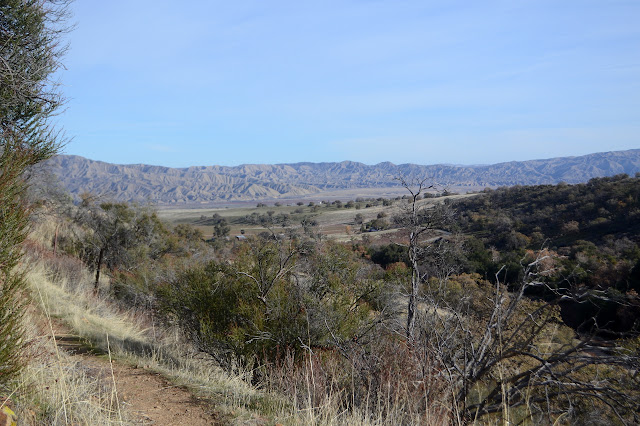
Here I am at Aliso Park again staring at McPherson Peak, or into the trees in its direction at least. My undoing! For seven miserable hours. That was a week short of two years ago now. It somehow feels both longer and shorter. I'm going to reverse my path this time. That way the battle that is finding the peak trail will be done in plenty of light. I've already done the initial part and found where the trail starts from the campground. Just past where the trail starts up the hill heading north, you can find the remnant of the old and official route of the road as it goes south up the canyon. It is easier to see as it rejoins the current road than as it passes through the campground. More importantly, where it once crossed the creek, there is a thin line that does not and instead continues north, climbing, along the hill quickly becoming very distinct trail.

It swings around to the south and climbs as it hits the ridge. The trail is easy to follow. There are actually two. The old one follows the ridge exactly no matter how steep the up or easy to bypass the minor peaks. A newer one makes a much steadier climb upward on a better trail bed. I stick to the new one as I climb. There is no sign whatsoever of the hundreds of ticks that haunted and hunted me when I was here two years ago.


The trail looks a little less used as it gets out of the grasses and into the brush. It's still something that would have been perfectly fine for coming down in the dark of the late evening.


The remains of a sign and post lie on the ground as I come around one little peaklet. Once there was a junction. The map indicates a trail at the forest edge and down, but the ridge within the forest is just an imaginary line between ranger districts now. There's nothing of it now if one was of the mind to try to follow it.

The climb is going great until I round one more peaklet to find the trail vanishes. Here one step, gone the next. I expected it to come with scrub oak up to my waist, but this is a steep, dry slope with almost nothing growing. There are suggestions of trail, each presented by the land with so little confidence that the questioning tone is clear in spite of the lack of speech. A half hearted cairn shows what is already known, that it is going up the ridge. The weird thing is that even with so little vegetation, each line that one might think is trail is interrupted by a long scraggly bush. Things continue in this apparent too dry to keep a trail mode until the expected scrub oak appears. I see multiple paths through here, too. I over the top or around the side correct? I clearly choose differently from most because the yucca in the trail have their bayonets in full working order. I thought I might scramble down the slope a little to try to find the trackables I lost up here, and undo some of the disaster, but one look at a familiar cluster of yucca brings back the memory of so many stabs I was starting to get used to them. Besides, the little bits of metal, now moved by two years of water or buried by two years of leaves, could actually have got lost while I was still on the trail. I just keep pressing upward. I'm not on the track I was on then, either. I don't see the sign post that was up here in a similar shape as the one below.
Once the trail settles back into trail, I'm on it. It took a little bit of just pushing through oaks. No one else has been for a bit. I saw two people hiking the trail yesterday, but I guess they didn't come up this far.

So I make it up the McPherson Peak Trail with a lot less trouble than I had going down it. There is only about 0.6 miles of bad trail along the way and it does fundamentally follow a ridge line. As long as one sticks to that, it should work out eventually.


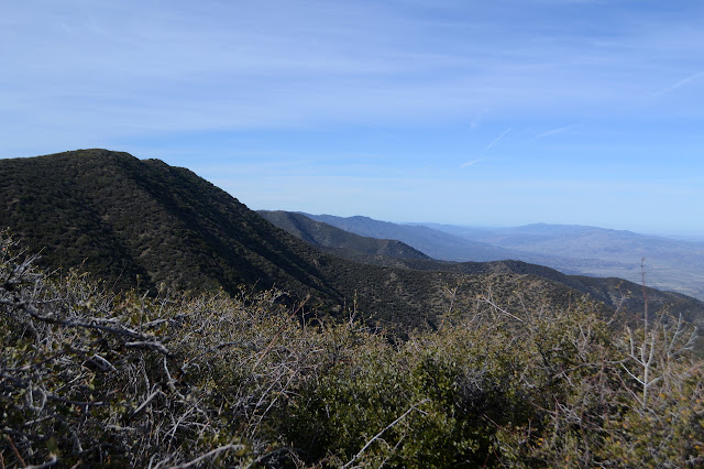
I look about for the loose USGS reference mark pointing not at all toward the Forest Service station mark, then turn my attention to Peak Mountain. I've forgotten how far it is to "just pop over there" and grab it too. It's almost three miles away. They're quicker miles than the last three. I've decided to climb it by the south ridge this time. It's a little longer, but HPS has their ways of encouraging the use of different approaches and I fully support that. Take different approaches, see different things! Not that most of them see much of it as they drive up the road and then have a very short hike to the top. I get started, but not quite yet on the road. I make my way over the nearby hill with a weather station and earthscope, then down the old fuel break before taking to the road.


I dither a bit about going all the way around to the south side of the mountain. There is a long stretch during which I won't, but when I get to the break off I'm back to thinking I might as well. The road miles really do go by a bit quicker. Then I try to cut it off by taking what looks like a thin trail. This bit of impatience earns me a grand thrashing to the legs by the short scrub oak and manzanita that populate the hill side before getting pushed back onto the road. At the south end, a trail goes up an old fuel break with plenty of clearance from any vicious plants.


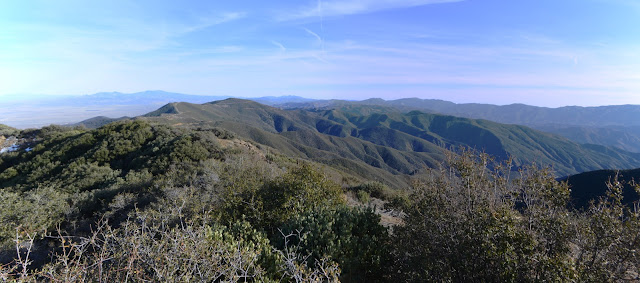
According to the map, there's lots of benchmarks along these peaks. In actuality, all but reference 1 has been felled by a bulldozer on Peak Mountain and it seems likely the others have had similar experiences. There is a bit more to see from up here than there was over on McPherson even if there was something that made them decide to put the lookout over there.


I take the east ridge back down. It isn't quite as open and clear of vegetation as the south ridge, but it's nothing too bad. Then there's those three miles of road and a little more because I'm going down McPherson Trail. It's longer, but it's certain to get me there even in the dark.

An old jet fuel tank marks a spring along the road below the peak of McPherson. I ponder a time when it made sense to buy up used fuel tanks to hold drinking water. Yum. Hey, eventually whatever is in there has been very diluted. It takes longer than I expect to get around to the trail down off the mountain.


The trail is more overgrown than I remember, but there's still no sign of all those ticks that were here before. There must have been 3-6 per step. I don't miss them. It's narrow in spots and set on a steep slope sometimes, but always clear exactly where it goes right down to the road below. The road makes a great night time walk under the stars and framed by the canyon walls.
©2020 Valerie Norton
Written 26 Jan 2020
Liked this? Interesting? Click the three bars at the top left for the menu to read more or subscribe!


Comments