Panoche Hills high point and Panoche Mountain
Panoche Hills
Click for map.
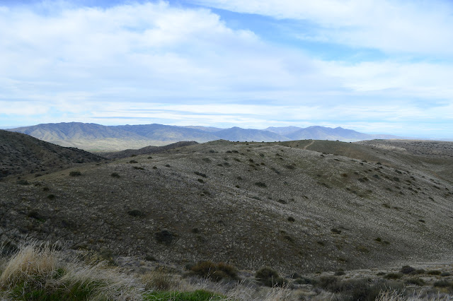
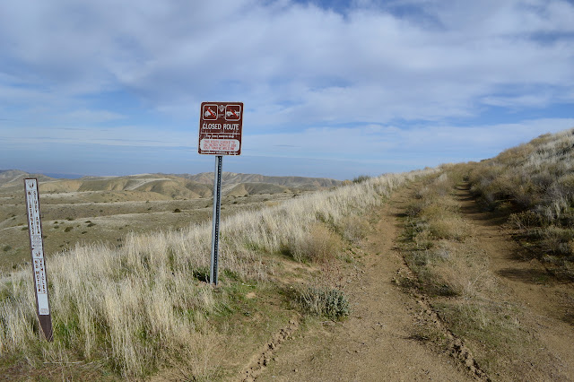
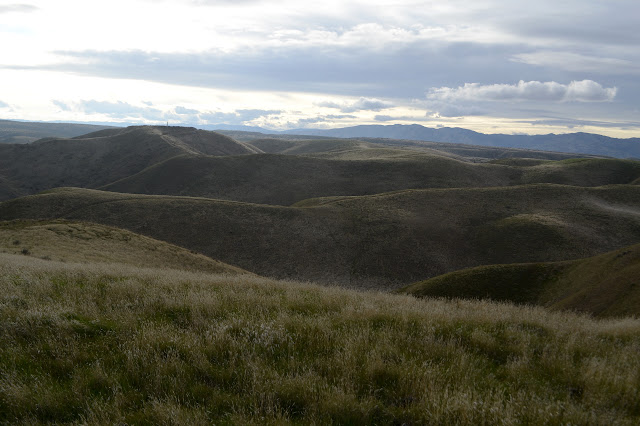
There's a lot more access to the Panoche Hills than to Griswold Hills to the south. A graveled access road comes up to the top from the northwest, then splits and continues a few more miles in two directions along the top with numerous more primitive roads splitting off both. Tucked into the east side of the main road (right fork) are a pair of wilderness study areas split by the road to the FAA VOR station (left fork). This means there shouldn't be any motor vehicles in those areas, but it doesn't stop the target shooting. With some rather nice views and lots of little roads down into spots with a bit of hill to one side, there is a lot of target shooting. It has me rather hesitant to go for the loop I had roughly planned. Still, between the rain yesterday and the weatherman insisting it was actually coming today, there doesn't seem to be anyone shooting now, nor has anyone driven up to start. I can at least do the high point and the named mountain in pieces to take advantage of the beautiful way this "rainy" day is shaping up, so I drove to the end of the gravel on the main access road and parked. The road is drying out quickly and I could probably get up very close to the high point even in my little car, but I'd rather like to have some time to walk and look around so see no reason to push it.


I get going on what should be a couple miles of really easy road grade with a tiny bit of somewhat steep climb at the end. The mud sticks to my shoes, vastly increasing the weight and the effort required to swing them forward with each step. Being sticky doesn't prevent it from being slick, so I have to pay more attention to balance than usual. The area is actually a patchwork of state and national lands and I keep passing little signs informing me that I'm entering or exiting public lands as I exit and enter other public lands. Other little signs indicate that the state lands are also to be treated as wilderness within the wilderness study areas.


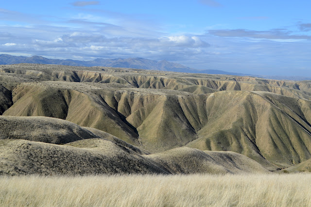
I walk along hoping to find a few things along the way. The information kiosk mentions that this was once all sea bed and was the sort that tends to form fossils. I'd like to find some of those it says are illegal to gather: big pieces of fossilized wood and impressions of leaves. These things washed down and got fossilized too. There's even a picture of a long tree trunk turned to rock featured. Everything I scan just turns out to be a ridge of darker rock on closer examination. All I actually spot are the old cuts above the current road for the old road which did more rising and falling as it traversed the hills.

My turnoff to a lesser maintained road comes very near the high point, but it still isn't visible until I am almost there. There's even a very minor (and not legal to the public) road right up to the top to service whatever the antenna is for.

There's a bit of failing barbed wire around the antenna and a metal cover with a rock on it. Moving the rock, there is a sticker almost faded to illegibility noting that this is a USGS seismograph. I've never found one of those before, just the Earthscopes measuring the slow movement of the land, primarily around the San Andreas Fault. It's quite close around here somewhere. I'm greatly tempted to jump a bit next to it, then ask my former housemate Alice (who has an excellent twitter feed) if she can see it. Maybe she can see when I moved the rock anyway. Snacks eating and view looking instead!


Heading off, it's my last chance to give the ground beside the seismograph a good jump. Come on, shake that needle a little! But no, I leave it as undisturbed as I can. I haven't heard a single shot and particularly not a single ricochet or the tones of a bullet slowing in the air instead of getting buried in the dirt. (Yeah, people really aren't all that into playing with deadly weapons in safe ways.) Maybe crossing that wilderness wouldn't be so awful. And I have choices for where I leave that I can make toward the end of the crossing. The loop passing the benchmark looks a little long, but I think I'll follow an old road for a bit, then make my way across the deeper valley to climb Panoche Mountain, for a shorter loop. I do have a little concern about the steepness of the south facing slopes, but I think I see one that looks good. It's a little way back the way I came.
The road roughly follows along the top of a line of hills edged by flat bottomed valleys. It is mostly a gentle rolling downhill, but there are some steep uphill pieces. Sometimes it even takes away most of my lost elevation. The road doesn't do much to make better footing, so it only serves to point out the way along the hills.


I sort of thought that these decommissioned roads might be more likely to direct me to something interesting, but all I find is the rare mineral the area developed. It and a couple rare plants are also singled out to show why the area is special. There are a couple spots with pieces all over the place. Most visitors still just think of the area as a good place to shoot and I'm happy I still haven't heard a shot today.


The last twenty feet down are challenging for the footing. There is a little water flowing in the bottom. There's a tiny and distinct world right there in the water and the wet. There's also a lot of very soft mud I carefully avoid even as I have to cross the stream a few times for good footing every time there is a bend.


I briefly wonder how I'll be sure that I've come to the right ridge to start climbing out again, but then I'm looking down a canyon at the antennas on Panoche Mountain. That'll do for a signal. The next one is the one I planned on. Again, the very bottom is quite steep and takes some care, but once past that it is just a chug.


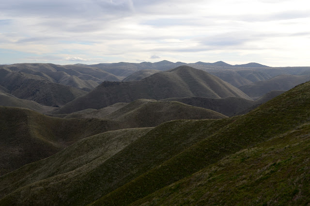
Once back to the ridge, I've got road to follow again. It does not in fact go all the way to Panoche Mountain like my map says. It stops at a power pole on the far side of a narrow, dipping ridge. There is still a little bit of trail and it wouldn't be hard without that. In fact, with the loose rocks on a steep slope, it would be easier without the trail that made those rocks loose. But so it goes.


There's a benchmark among the antennas and microwave relays, but it is within the fence. It looks like it might be a PLSS mark at first and is even very close to where there might be one, but as I stand on my toes to try to see from just a little higher, it does seem to have a triangle in the middle like it might be the station. There's not much to see from this one.

Checking out the ridge with the cliff on the other side, I think it would have been fine to come up. I'd have saved 20 minutes and that extra 200 feet. Ah well. I head back along the narrow cliff and then wind along the ridge to the VOR station. It twists so far, it looks like it must be twice as far along the ridge instead of directly, but it's only half again as far.

From the VOR station, it's all easy graveled roads back except for one little shortcut near where it forks.


It's dark by the time I get back. I only did a very rough estimate of the length of the loop at 12 miles, but it is actually around 16. Not one single shot rang out where I could hear it all day. It was absolutely lovely.
©2020 Valerie Norton
Written 11 Feb 2020
Liked this? Interesting? Click the three bars at the top left for the menu to read more or subscribe!


Comments