Flat Tops: Lost Lakes and Peaks
Routt National Forest
White River National Forest
DAY 1 | DAY 2 | DAY 3 | DAY 4 | DAY 5 | DAY 6
The night was quite mild and I used the quilt alone, but the morning is cool enough to keep the mosquitoes at bay almost long enough to have breakfast. Just the elevation change is not enough to explain the warmer temperature. A number of lakes, including the Lost Lakes, lie ahead, and then a climb up to the slanted flats above and eventually to the intersection my proposed cutoff would have got me to quite a bit earlier. The map indicates that it is quite dry up there until the finish, but there have seemed to be lakes nearby so far. I am starting with a little more water than I have been just in case it is true. It certainly does start off passing lots of little ponds as indicated. When I get nearby, I will see how I feel about doing a benchmark and a peak.


It seems it is a good day for wildlife. Well, a few large forms, anyway. It starts off with a few ducks.

Coming up along flowing creeks, the trail heads out across a meadow. It looks like it will be a soggy walk in a couple spots and looking at the map, the junction is out there. I will have to repeat the soggy walk right back again. There is a track, only slightly thinner, cutting off the meadow to the right that looks very nice and dry. I decide to skip the crossings and try the dry route through the trees. Sure enough, it quickly comes to another trail, a buck with a velvet covered rack, and more ducks.


A little further along is West Lost Lakes. There are two fishermen along the shores, but as I come into view, one gets up and vanishes toward the campsites. The trails split a few times. Apparently most people stop here because the largest trail is not the actual one, but more campsite trail. As I come around, I find out why as he and a woman are both holding a growling dog by the collar. They obviously know their dogs are neither leashed nor under immediate voice control and in fact are probably a danger to wildlife and other hikers. You would think that a rule that spells out why it is there would be easier to follow, but there is always someone. It is good to know that my safety is much less valuable than having the dogs along and free to roam. And what would they have done if I had come the direction I had originally planned where they would not have seen me coming? The dogs look very capable.

I give them a cheery hello, but listen to every little sound as I find my way back to the main trail. It is not far as it went around the bottom of a hill just big enough to hold a campsite and the track I am on went over it to access the campsite a few feet up at the top. After that, it is time to start climbing for the peaks.

Getting to the ridge and new views is not as impressive here. I can see nothing through the trees. More climbing gradually fixes that.


Trappers Lake is much bigger than the other lakes I have seen so far. Even the reservoirs are dwarfed by its expanse. As the land below comes more into view, more and more of the destruction from the 2002 fire around it is clear. Many square miles have been reduced to standing dead toothpicks. There are a few small islands of green. Up the mountain sides, there are stripes of green. Otherwise, the fire was very complete with its destruction.

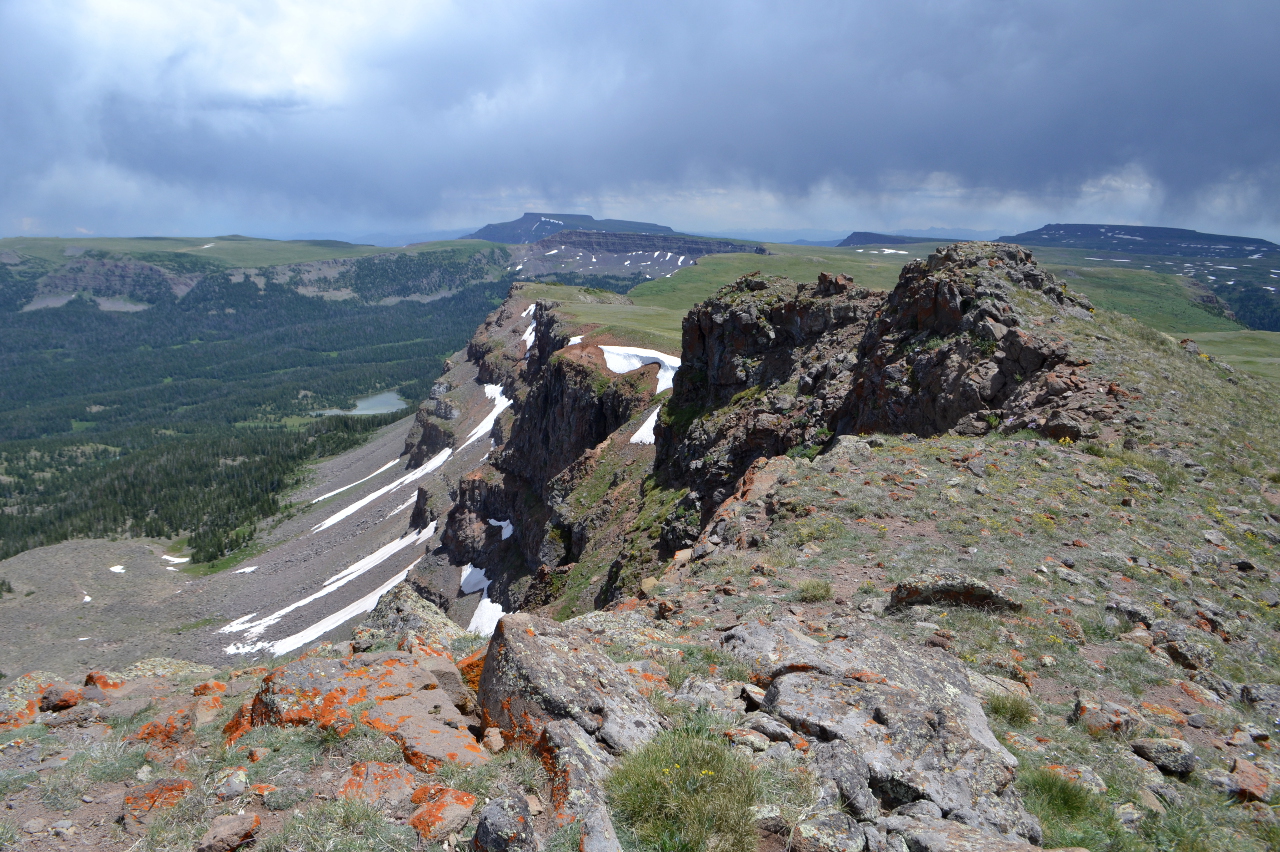
As I reach the flats at the top, I cannot help but notice the clouds are gathering even earlier today. Even small ones have been showing that great attempt to rain down and a few of the larger ones are looking a little successful. It is not all that desirable when expecting to spend the rest of the day consistently about 11,500 feet high. It is clear and sunny for now and the peak with the benchmark is a short walk and even shorter climb away. I am second guessing that the benchmark is, in fact, there rather than the high point up ahead because it is supposed to be "at the highest point" and this is a few feet shorter. I put aside my doubts and a few heavy bits and go for it anyway.


The first bump along is just a warm up. The second has the rock cairn, but no benchmark. It does seem to be the highest, but maybe the next is higher. More importantly, the next looks more attractive as a base to place a benchmark. Sure enough, there it is. There are no reference marks. The view is nice, too. Way down the ridge is another bump that probably has an amazing view, but I do have places to go today.


Back to the trail and loaded up again, I start toward whatever is next in store for me. As I edge a little more around the peak, I can see that this side of the mountains is not quite devoid of lakes. There are some far down the hill from here, but not so far as to be unreachable if water is needed.

The trail becomes hard to follow. Of course it does. There seems to be a low route and a high route. Maps show the high route and since I want to go up the peak, that is more attractive to me. The trail is too unreliable, so I just proceed upward at a comfortable climb. Out across the flat there is a nearly complete rock square planted on the slope. It is an actual stone corral. I have seen a couple trails named for such structures and sometimes one is marked on a map, but the structures always seem to be long gone. There is no indication of this one on the map, but there it is. A stone corral. The trail probably goes near there, so I aim toward the top of it. Meanwhile, the wind is picking up, the air is getting colder, and the desperate attempts at rain by the clouds do feel very much like rain at this elevation. The air is so dry that I do not stay moist for long.


There is a rock just short of the stone corral that seems like a good jumping off point for peak bagging. It is still trying to rain and windy, but the clouds are whipping across the sky quickly. Patches of blue are out there and one looks like it might be timed for a climb. This is a much steeper climb and the trail is a little lower, but it is nothing too difficult. I go for this one too.

The weather does coorperate for me better than expected. Not only is it a bit sunny as I arrive, the wind right at the peak is very little. The wind was actually a greater worry since there is a bit of a cliff off in the direction it was blowing.


I head down again before the weather gets too much of a chance to change its mind about the brief mildness. It is trying to rain again once I get to my stash. There is trail to follow again, but it is short lived. I get lazy about staying high, seeing goes high and low. This works out just fine until things suddenly seem to be cliffing out in front of me. Above, the trail is visible and there is even a trail marker, so up I go to follow it while I can.


The trail is good for a while again, but it cannot last. Gradually it becomes a game of spotting sticks or cairns, or not, and just wandering along the grasses. It is easier to walk a trail than they uneaven and sometimes soft ground, but it just does not quite seem available all the time. Even the map seems to just be winging it for the trail route.


I keep finding a bit of trail as I get close to a stick or cairn, but once I get to the trail marker, the trail vanishes completely. Over and over again this happens. As I get close, I can see the trail along the Devils Causeway. Once that joins the trail, it is well established although there are still a couple places that could not be followed just based on feel. Good thing that is not the usually way of following trail.


There really were no lakes for the last few miles. Up ahead, I can see a number of lakes going down the hill to the west, but none seem particularly near the trail. They do not seem to have much trees or rocks or anything to block the wind that is still blowing a little harder than is desirable. A bit further down to the east, there are lakes with good wind breaks, but getting down to them would be difficult. As I am wondering where a good camp spot might really be, there are two small ponds beside the trail. They are quite unexpected. Down around the second one is a bit of rock with a place to camp behind it. Perfect! Except I am not quite yet to where I "need" to get to to complete the trip by my deadline. I am nearly two miles short, in fact. Not knowing what might lie ahead, I really want to use this spot. Certainly nothing will be quite as convenient.


Of course I could just gather the water I need for camping and hiking tomorrow, then go on just wanting a good spot to sleep. The place before me wins out and I settle for forbidding myself to even think about going up Derby Peak tomorrow since I have now added these extra miles to that day. It was not even on my radar until some guy with a fishing rod said he was going up it.

Even with the rocks, I decide to put up my shaped tarp against the wind and the unlikely rain. I have never actually pitched the thing except halfway in the yard and it seems I should at least try it. My selected spot is a particularly hard place to place it, but I am up for the challenge. As the sun goes down, the wind dies as well, but it is nice to have the tarp. It is surprisingly warm inside its shelter.
Continue reading: day 5
©2016 Valerie Norton
Posted 12 August 2016
Liked this? Interesting? Click the three bars at the top left for the menu to read more or subscribe!


Comments