South Twin River
Humboldt-Toiyabe National Forest
Click for map.
For some reason I have thought of Nevada as a flat land, maybe because there was a vast sea here once. I decided to break myself of this thinking through practical experimentation. Look at a map and there is a bit of green in the middle like some sort of bear scratch. That is some of Humboldt-Toiyabe National Forest and it sits upon islands of mountains, many of them a bit too tall to go visiting without extra gear for a few more weeks. The forest claims to be the largest in the contiguous states, but that is a little misleading since it is scattered in chunks all over Nevada and California. It was becoming clear that if everything is planned, there will be no time left to do it, so I took off with only a scaffold of a plan to hang everything on.
First on my list of places to be is Arc Dome Wilderness. The mountain itself is one of those that is tall enough to have a bit too much snow on it for a casual climb until next month at least, but it has low trails as well. I could even find trip reports for the area. I decided to try South Twin River. Looking for NF-080, I found it more clearly marked with "South Twin River" instead. The dirt road up is narrow, but smooth. The trailhead has a bathroom and an information sign that is specific to the wilderness including a rough map of trails and trailheads. This trail is part of the Toiyabe Crest National Recreation Trail. The trail starts right behind the sign and climbs quickly although there is also obvious trail following a long gone mining road along the river. After the first steep hundred feet, there is a sign nearly blank with age forbidding motor vehicles to reassure me that this is the correct route.
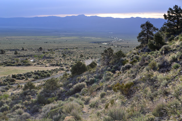


The sun had just hit as I started up and I am just getting warm as the trail crests and drops into the rugged canyon below. It is mostly shadowed still and a thick cold is being stored within. Thoughts of removing my light jacket vanish as I follow the trail as it dips and climbs again through a brief widening of the canyon. The old mining road that went through the canyon is not so vanished here where it climbs up to meet the trail.
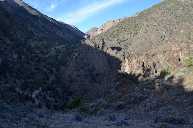


The trail follows the road over another crest. There are signs of ranging cattle in old fencing and coiled barbed wire right at the top. Although I have seen information that this is still used as range land, I am not seeing the old plops everywhere that usually go with that. The cows are certainly not out yet. Beyond the crest, it drops down beside the river.


The trail keeps threatening to cross. The river is not very big, but it is big enough to expect wet feet on the crossing unless there are some very nice rocks or a good log. The third threat comes true in a spot widened by foot traffic. Nothing seems ready to help me keep my feet dry anywhere near it. Neoprene socks can help them stay warmer in the snow melt, though. I plunge through and it is not bad except that my feet are heavier on the other end. It is all open and easy travel to the wilderness boundary on the other side.

The second crossing is even wider and also offers no dry feet options. I plunge in again to find that most of the moving water is in a narrow band where it is deeper. It takes careful, slow and deliberate, movements to get through this without tilting over. I am glad to have two poles along so that I can always have a steady tripod on the bottom. At the end, I am surprised to only be wet to just below my knee. It felt a bit deeper while pushing through. The third crossing comes rather quickly after as the canyon narrows down into something rugged again. It has clearly stepped up its game again for challenging. The crossing is narrower with obviously fast water going down the middle. The river has thrown in an obstacle of a couple thin trees to step over right there where the water is swiftest.

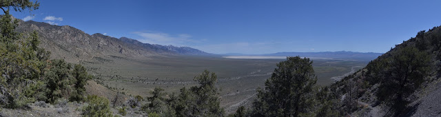
This is just the very start of the canyon narrowing down again where crossings can be expected to be more numerous and swift. The rock wall to my left offers no help, but the hill a little before it does not look so bad. There is probably a way up, whatever might be on the other side. I entertain doing just that briefly, but then what? There are all those trailheads marked on the map below including nearby North Twin River and some that do not follow creeks. The option to go back now rather than later when the sun has had the opportunity to increase the water through the crossings actually seems pretty good and I turn around having barely stepped foot inside the Arc Dome Wilderness. Wading through the first crossing again, I notice a row of rocks beside me, placed evenly about a step apart. Stepping stones for when the water is less than a foot deep.


On the way, I do dally a bit. The outcrop by the partly removed fencing looks like a great place to play with my art supplies. Afterward, I wander down along the old road to see what is down there. It ends in a pool made deeper by a log jam just below. People have followed it in, but I cannot tell where they go after. A surveyor has been dropping plastic posts in the rocks for something, but I cannot find what was interesting to them.

There are a few campsites and someone has placed cairns up a drainage as though that was trail. I take a much easier way up and back out to the basin again.
Back at the parking, the road continues on to North Twin River, but the ford does not look usable. The far side seems to have been cut into so that it rises so steeply out that my car probably would not be able to do it. An adjustable dam has been placed below the ford to collect the water into a large pipe and it is currently placed to make the ford far deeper than it needs to be. There is another road up from the highway below for that trail, but I decide to go after Ophir Summit instead.
This was a more planned stop on this trip and it has already fallen through. This does not bode well for the rest.
©2017 Valerie Norton
Posted 24 May 2017
Liked this? Interesting? Click the three bars at the top left for the menu to read more or subscribe!


Comments