Sisquoc River trail work
Los Padres National Forest
Click for map.
This is another bit of volunteer trail work hosted and organized by the Los Padres Forest Association. It is a little longer with groups coming in Friday morning or Saturday morning, all leaving on the holiday Monday except one hiking out earlier. Food and BEvERages are provided with a dedicated cook for the preparation. Since we can drive in, it can be quite elaborate. I opted to come in on Friday.
Friday
We gather at the Lower Manzana Trailhead at 8AM. From here, there is the option of hiking in while others carry any gear and a few people take that opportunity. At least one is even going to try out Hurricane Deck for their route in. The rest of us collect into a reduced number of high clearance 4x4 vehicles to travel the private road that accesses the ranches near the Manzana Schoolhouse. This is something quite new to us since in general the public has no access, not on foot and especially not on bike, to this road. It is rough and extra long, climbing high over a ridge before dropping down again with great twists the whole way. The creek crossings are a bit rough and one is wet. They should all be wet this time of year, but it has been another miserable rain year.
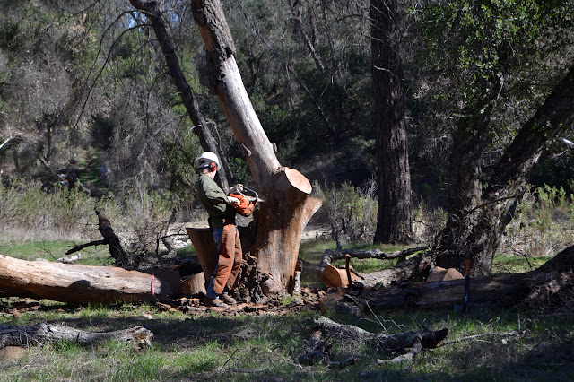
Once in camp, we set up. There are some rather tall and dead trees in camp as well, so we try to avoid them. Since we are still not quite in the wilderness, out come the chainsaws to make the camp safe. They knew these danger trees were here and came prepared.
The rest of us are told that today is an optional work day, but that is just silly. We have lots of tools and the whole afternoon and we came here to work on trails. We get the safety talk and the sign in form and collect tools for working along the Sisquoc River Trail. The overall objective is to work everything to Water Canyon, about 4 miles up. First we have to locate it, somewhere across the dry Manzana Creek. It is not entirely clear where the trail is supposed to go through the camp, but someone has put up a cairn and one can eventually spot the signs on the other side after enough looking around. We head out, each with a pair of loppers and a trail smith. (The trail smith is something Mike Smith has been working on and there would be more of them about if he had more time to put them together.)

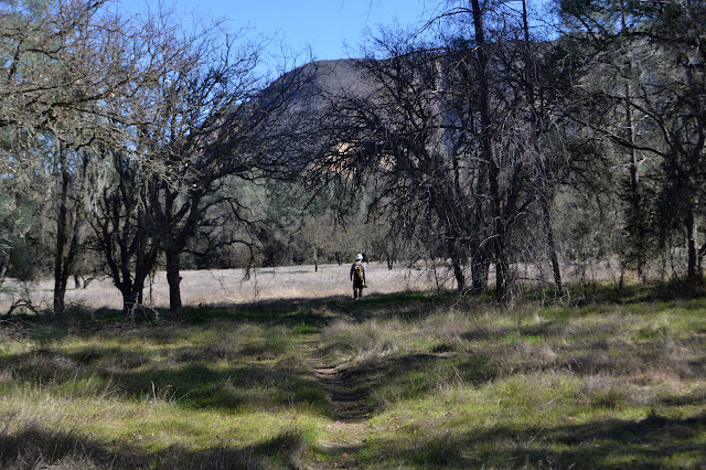

The trail is old wagon road from when this area was first settled. There were a lot more families making a living here until a period of drought showed how hard this land can really be. We cannot see it on the flats, but when there are slopes, the wide cut becomes obvious. Along the savanna sections, there is a little work to trim low branches for horseback riders and a few bursts of ceanothus to cut back. Mostly, we just walk these. The slopes, especially the west facing ones, are full of sages and these are most of our work. The trail smiths make quick work of the brittle brush. A few are trying to take root in the old road, and it makes quick work of that too.

But as the afternoon wears on, we call it a day. Having brought the tools out this far and feeling pretty confident about what we have done so far, we stash them under a tree above the wash of a canyon. We have done about a mile and a quarter already. As we walk back, I cannot help but give Wheat Peak a good look over plotting how I might want to climb it.

Back at camp, we still have a couple hours to sunset and there seems to be some time until supper. There is time for a little fun. I have noticed that there are a few benchmarks, ruins, and graves marked on the USGS maps of the area. It seems I am not the only one because "Trailhacker" set a virtual geocache at a nearby grave after seeing it on the map and then taking a few hours to find it with his estimated coordinates and GPS. I figure this is an easy way to see what the marked ruins and grave on the map translate into on the ground. The point is only a half mile away, so seems like a rather reasonable goal. It could be as much as a mile of actual walking, but probably not more. I can manage to get one companion, Conner who drove me in, on my little expedition and we take off for the Sisquoc Trail as it heads downstream instead of up.

It is difficult to say where the trail goes exactly, but across the river is is likely always changing anyway. On a long diagonal across it, we can see the old wagon road climbing up onto the ledge on the far side. The crossing is surprisingly far. By the time we reach the bottom of the ramp up to the higher plain, we are already halfway there. Following it further along the top is initially not so hard. A creek cuts across and has eroded into the old surface making people get a little creative about crossing, but the old road is clear again on the far side.

It gets harder to see as the way becomes a swim through dried mustard, but it is a very shallow stony wash section that finally gets me. It might be that I am paying too much attention to where the point in my GPS is and not enough to the trail as I get within 500 feet of my objective. There is evidence of others going before me, squeezing through the brush, but as we wander, I make a wrong choice and that ends too. My feeling is that there should be path to the right and there is a tunnel. Is a short crawl acceptable? He says whatever so we slide through a short spot to a more open path through the brush. Again there is evidence of someone coming through, though not much. Past a broken branch, it is smooth sailing to the GPS point marking the grave.

The chimney of the homestead is clearly visible to the south. Of course we must visit this too. We cross the suggestion of an old road just a few tens of feet north of it. I was wrong as to the direction I had lost the trail. The chimney includes a large stone set across the top that looks imported to me. It is cracked, but metal rods also help hold everything up. People through the years have been carving in it. I cannot help but call it all graffiti, even the marks from a ranger over 50 years ago. Besides the chimney, the only evidence of a home are a few pieces of iron that were probably once a stove. I can see nothing of the walls or even the footprint of the place.

Following the road back to where I lost it is easy and involves no crawling or even ducking. We retrace our steps from there for, indeed, about a mile to camp. Food is getting a lot closer to ready as we return triumphant. The evening proceeds much as one might guess it would with drinks, plenty of food, and a campfire with a whole lot of fresh cut oak to supply it. It turns out we are trail workers and find ourselves a bit sleepy as "hiker midnight" comes along.
Saturday
We are up and fed and with our lunches packed and heading for the hills where we left off the day before around 8AM. Ice sits on the grass of the first ledge in the shade and where the sun has just recently hit. It might be a little chilly this morning. I overshoot my target for starting work, then go exploring why it looks like there are two buckets hanging from a tree on the first ledge after a river crossing. Turns out, it is because there are two huge buckets hanging from a tree on a stout rope. It looks like some sort of bear bagging. I am almost curious enough to scamper up the tree and pop a lid to see what is inside. The tree looks easy enough to climb and provides a great place to stand and look, which rather illustrates this is not a good sort of bear bagging. It is a head scratcher. Instead, I head back across the river to the sages that need pushed back before they devour the trail and are still in the morning shade.

We finish up with the sage and a little more soon enough and cross the river (again) to where the other group was working. There is an old fence and fallen gate to cross before climbing up, but no indication of why. They were working on a steep slope used as trail currently, but this time I want to try the road that was obvious below them. There is a little bit of trail on it from some minor use, but it has mostly been abandoned. Besides a low oak branch to duck under right at the start, there are no obstacles to using it now. Once at the top, there is nothing obvious to show where it goes, though, so I turn to cross the grasses and rejoin the trail to the north where it has moved. We skip past the others recovering trail along a tributary where the old road is no longer evident, then find our own projects. Mostly to do with battling back the huge sages.

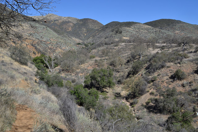

The old road does come back, though, acting as if it had never vanished. We clear the brush as it descends toward a campsite on the side of the river below. The last section is thin and steep, but clear. The trail, however, is supposed to stay high for at least another half mile. Things get confusing out here. A second trail down by the river and very clear heading back the way we came helps to illustrate that.


We finish at the campsite and stop under the trees only to find the ruins of another homestead. Someone has placed a plow out by the (incorrect) trail to help others find it. Under the trees are some walls pushed back into the hill side, similar pieces of a stove, and a huge ring for a barrel. These ruins are marked on the USGS map but have nothing else marked nearby.


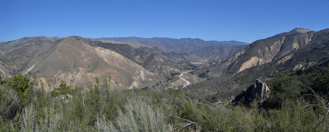
We head back, most choosing to try out the river route. It is easy while it crosses the flat flood plain, but then it gets down into the river. People have flagged it and in some areas there are cairns to help and some of our number know of the bits of low ledges you can get onto to not have to walk in the river. Walking in the river is rather hard work because the sand is soft and has plenty of rocks. I try out a ledge on the far side while most are going down a rocky sand bar, but find it not very good for travel either. While flat, it is not easier. Some feel it was a good route and some would have preferred to walk the hills and high ledges.


Since we came back a different way, we did not get an accurate measurement of the work distance for the day. We were probably about 3 miles along when we stopped. Back at camp again, we have some time but I have no second excursion planned. Since I have not gone up to see the schoolhouse yet, that seems like a reasonable visit. People have made a steep path directly up to it, but I head around on the easy road for a much more pleasant route.


The evening is a little more subdued than usual for these trips, but with more people from those coming in today, there is a little more rowdy. Not much and we are still almost entirely to bed by "hiker midnight".
Sunday
We are up and fed and looking to get tools to trail by 8AM again, but only a few are off to finish off the trail to Water Canyon. The rest of us are heading up toward Hurricane Deck to work the tread of the approach trail. We have had small spots with poison oak, but here it is everywhere. Sawyers head up first to remove the few fallen trees. We have a pair with loppers heading up too, but they seem to be leaving the encroaching poison oak. The largest group is up with trail smiths to reassert the trail where needed and just clarify it where it is not so bad. Happily it does tend to dry a bit as we climb and there is less poison oak. Switchbacks get maybe half our attention while decaying tread gets the other half. Switchbacks are shortened and lost by falling trees and encroaching vegetation. Some are lost in that they are hard to see and hikers have continued forward and ended up heading directly down the steep hill.
For one section of trail, we can find both ends, but no indication of how they connect. The trail has simply been unused for too long. New trails get very creative around it and some go wrong in extravagant ways. A few large and very old fallen branches lay over the line between the two sections, so we set to dig it out and make everything clear again. We keep on working until the trail makes it to the ridge line above.


The trail is a lot easier to hike and certainly easier to find as we come back down. We worked another mile and a quarter, but unlike the first day, we worked just about every inch of it on this one.

I really have noting to do until supper except relax today. Tonight, the group is very boisterous after getting fed. A few barely make it to "hiker midnight" still, but plenty make it all the way to actual midnight.
Monday
Today is not a work day and our morning wake up call fails to go out although breakfast is ready not too much later than the last two days. This does lead to a few missing their coffee. We pack and head out, getting to the cars before noon. It may not be a work day, but there are still a few who have tools to clean and sharpen, so this gives them time to "not work" on that.©2018 Valerie Norton
Posted 2 Mar 2018
Liked this? Interesting? Click the three bars at the top left for the menu to read more or subscribe!


Comments