Posts

Showing posts from December, 2018

sketch

Image
Finally! But only the one. The book is there, but I keep taking off on hikes that will take the whole of the remains of the day. (Usually all of it.) Admiring all the mortar stones and their view.

Hackberry Peak

Image
Mojave National Preserve Click for map. I was eyeballing the "Bobcat Hills" as a nice spot to hike, but then decided to go for the much higher spot on the other side of the road in the middle of a green wilderness area. Oddly, it seems to have a few roads reaching into it. I can drive in as far as I can and then, at worst, it will be 4-5 miles to the top. There is a handy camp site (or three) at the parking I used, which works out great. (The Mojave National Preserve allows roadside camping at well established sites with a metal or rock fire ring. You are required to pack out all trash including ashes and toilet paper and may not "improve" or increase the site in any way.) I probably could have driven in further, but there just doesn't seem to be much point. Dawn sunlight playing on the hills. This is the road. The day dawns pretty, but inauspiciously. Just 10 minutes after the sun breaks the horizon, it hides determinedly behind an increasing bl...

Dunioth Mountain

Image
Calico Mountains (BLM) Click for map. You know what? It's cold out here! One might even think it was a bit into winter. I have this idea to wander over to places that have large prominence peaks, but they tend to be even colder and particularly cold at the top and, well, maybe now is not quite the right time. So, with a little bit of grumping, I am off to an opportunistic bit of peak bagging in the Calico Mountains. The mountain itself looks fun except for the swarm of truck trails wandering all over it. (Also, the sounds of ammunition from random target shooting isn't inviting.) A geocacher offered up an alternative (by way of putting a geocache at the top) that looks much quieter and can even be done in the few hours of light left in the day. The mountain is actually unnamed, but this person dubbed it "Dunioth Mountain" without explanation. I may as well call it that. One name is generally as good as another. Already in shadows to start on the late after...

Remington Ridge to Lightner Peak

Image
Sequoia National Forest Click for map. It is time for another peak, surely. The rain following the hike up Mill Creek was snow in the very high elevations and I can see the dusting on a few of the peaks nearby. If this has added to more already on the higher peaks, I don't know. Hopefully if it is there, it is still little enough to trudge through. Remington Ridge is another motorcycle trail that gets plenty of hikers. It gets plenty of the motorcycles too and I can see their tread in the trail along with one pair of boot prints on top of them all. It's some 5 or 6 miles up to the peak from here and I would again like to be back by dark. No rain expected today, it just gets cold without the sunlight. Signs at the start to make it easy to find. There are all sorts of people parked across the road from the trail and further up the road in the larger turnouts. The trail looks almost untouched today, so they are here for something else. I expect one of the area hot...

Lake Ming

Image
Lake Ming County Park Click for map. To walk around Lake Ming was just a spur of the moment thing, but there it is and there I was and it is possible to walk around it. Besides, there was this weird goose that was just standing around in the cold wind. One goose with a fleshy face like a vulture. Maybe more like a turkey. There is no path to start around the lake, only the parking lot or the picnic areas to walk through. There's not really anyone to disturb while walking through the picnic areas today since the wind is just getting stronger and coming right across the water for maximum chill. There are a few visitors, but all are out moving in some way. A few are fishing. Little fenced in playground to the right and picnic tables and lots and lots of parking. Yep, it's a county park. No swimming, though. At the end of the lot is a wide road signed for pedestrians and bikes and definitely no motor vehicles.

Mill Creek to a mortar stone

Image
Sequoia National Forest Click for map. One of the Kern area geocachers has been slowly setting a series of "5 Mile Hikes" at the 2.5 mile mark on some of the area trails. It's really quite a nice chunk for a lot of people. I have intended to do a few of them (probably without using the cache as a turn around point) but never seem to get to it. One has been set on a trail I know from attempting to hike up Breckenridge Mountain one day after a snow storm. The top where we were trudging through ever deepening snow and the middle where we were washed with quickly melting snow were not so great, but the bottom was quite lovely. (It probably didn't hurt that our feet were dry when we first got to it, either.) Since I'm familiar with this one, I thought it would be a good one to take Timmy on. Yes, I'm bringing the cat along again. I've devised a way to easily carry him, too, since he is still 19 years old and that's quite old so I don't expect...

Rockefeller Loop

Image
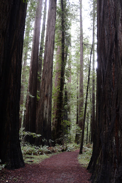
Humboldt Redwoods State Park Click for map in new tab. I stopped at the Rockefeller Grove intending to travel a bit of the River Trail until I felt like turning around. Well, I missed the narrow steep bit of road that looked like it might not even be paved and stopped a little further down the road, but close enough. Turns out the road is paved down to the parking, although very narrow. I pick a direction at random for the loop. One is surely as good as another. Looking out over the river toward where a bit of blue water, colored by a different silt, pours from Bull Creek into the Eel River. Signs characterize the difficulty of the loop and mileages along trails on the other side of the loop. The trees are pretty big. None of them quite rivals the Big Tree at Big Trees just a couple miles up the creek, but that was a particularly impressive specimen. The overcast of the day is all sorts of gloom, but it seems to be higher than the trees, so the tops are only lost ...

Hammond Coastal Trail and Mad River Bluffs

Image
Mad River County Park Hiller Park Mad River Bluffs Clam Beach County Park Click for map. Hammond Trail is a generally paved ACA compliant trail that runs from the Mad River Bridge up to Clam Beach where I started hiking a month ago . It is signed at many exits along the freeway and seems to be popular, so I intend to see what it is all about. The Mad River Bridge is the closer end, so that is where I start before the rain starts tomorrow. There are about four spaces for trail parking at this end, but the signs are set for hikers so that they know where they've stopped already. Fencing lines the walkway up onto the bridge and across although taggers have opened it up in a couple places for views of the river. (That wasn't their purpose, but it is an effect.) Not a particularly auspicious start. Mileages and amenities marked at the Mad River end of Hammond Trail. Parking is behind the fence to the right and more signs for the trail are at the end of it. I...

Hennessy Ridge and the world's largest tan oak

Image
Six Rivers National Forest Click for map. After finding no trails coming up to the ridge and the "world's largest tan oak" from near the rest area below, I drove up to Hennessy Ridge. It feels silly to drive more than 10 miles to get 0.9 miles away, but there is some climbing as well. There are a couple roads up and the one signed for Hennessy Peak is not bad. It was once paved for the length from the paved South Fork Road up to the ridge, so has a few deep potholes to look out for. Once on the ridge, there is a spur road. This was paved once for a short way, but after that is often one lane and, since I overshot the tan oak, eventually has areas where the vegetation drags along both sides of the car. I parked at the edge of a longer two lane section just past a blocked road heading up to the ridge that I hoped was the higher ridge route shown on a map I looked at before but do not have. A single lane section of the road where passing could be had if someone...

Tunnel Flat and down to Trinity River

Image
Six Rivers National Forest Click for map. There seem to be almost no hiking opportunities near 299 as it passes through Six Rivers National Forest. There is a trail way at the end of South Fork Road and then one at the end of Denny Road. That second one is actually in Shasta-Trinity National Forest though. You're supposed to come here to raft. There is also a point marked on the visitor map high on Hennessy Ridge that says "World's largest tan oak" and a rest area with mysterious trails in the back just 0.9 miles from it. It is also 1500 feet, give or take, up. If they don't have a trail up to the tan oak from the highway, I feel like they have missed a trick, but it would be reasonable to expect it to be marked if they do. Anyway, I am going to see where these trails go. The bit of trail out the back of the rest area. It's a nice little rest area. It doesn't take long to find where the trail goes. It goes to the highway again. There i...