Belmont Mill and Babylon Ridge
Humboldt-Toiyabe National Forest
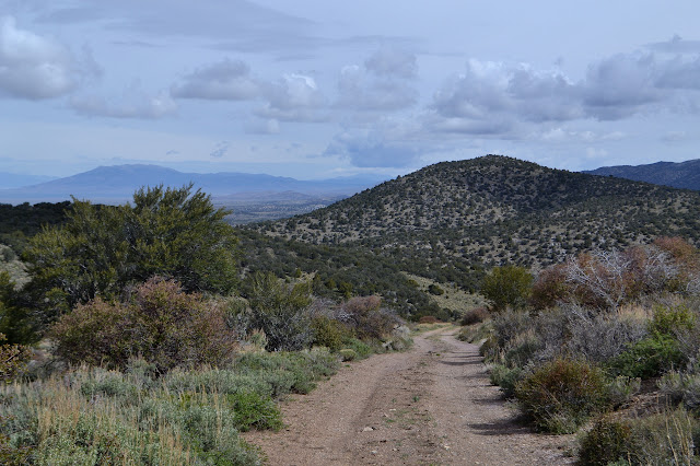
Click for map.I was heading up to Treasure Hill to look around for the day when I got distracted by a geocache just short of Hamilton. I had just found one at the cemetery and there were very few others because they seem to only be placed in special spots around here. It is off my path, but curiosity got the better of me. I started to drive the road in the direction, but it was quickly apparent that it would be at least a little foolish to continue. I had packed my pack in anticipation of finding some short hikes to do, so this would just be the first.

The area is riddled with mines. The first one I notice is only a few hundred feet along and tunnels deep into the rocks just a few feet below the road. I wonder how safe that little bit of road might really be. The road splits, one bit heading north and a little east, one heading west to connect up with a canyon going northwest. That seems like my route since I need to work my way northwest. It does not matter how I do it, though, and there is a little peak beside it all, so I climb it on a whim. I will just grab the road again down in the canyon on the other side.
The ridge is quite easy to climb. There is metal litter all along the way and many old stumps. An old fuel break must have been cut. Very old as the trees growing on it now have gotten quite substantial although not as big as those that were cut. I pause at the top, then make my way down the steeper slope on the other side to the road below. On the way, the sky gradually reminds me that I meant to have my raincoat with me no matter how short a hike might be.

Down in the canyon and on the road again, I continue to wander downhill. It gets me closer and closer to the point in the GPS. The creek bed of the canyon is dry as the road makes the few crossings. Everything about the canyon says very little water comes here and what does goes again quickly.

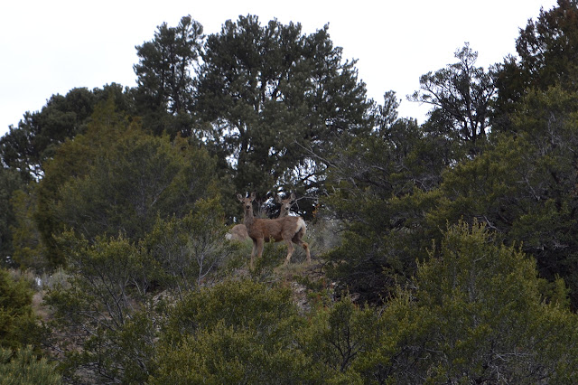
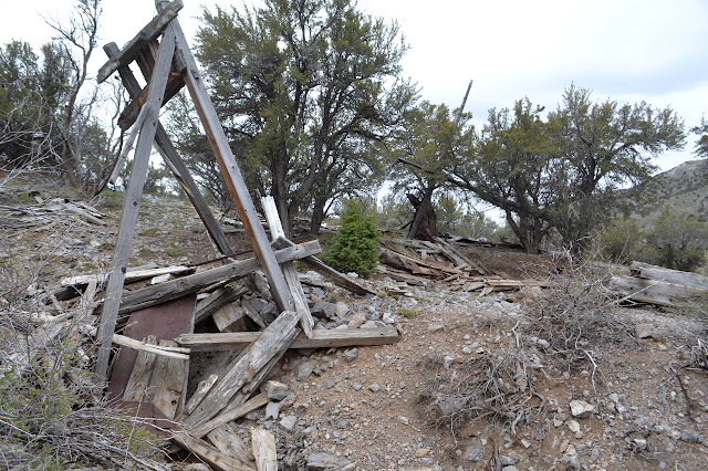
As I get very close, the road begins to turn away, but there is a junction. Turning up the next canyon, there seems to be a post or two up on the hill. Something has been built up there. A pair of deer look down on me as I turn a corner to find quite a lot is built up around here. First I see a row of buildings, the last one collapsed, then there is the Belmont Mill.

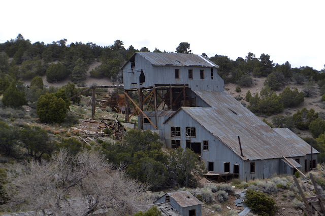
Roads go all over the place on my map, especially around a nearby spot labeled "mill site" as well as the one labeled "Belmont Mill". There were roads coming from the west by where I park, so there is probably something back from this road. I continue up the new road looking for any place to turn left. A tram system was built on the ridge to my right and the cables still stretch between the pylons.

As I follow the shallow McEllen Canyon gently upward, there is a pair of tracks heading off to the left. They do not look used, which around here probably means they stop at a hole in the ground in a short distance. I cannot see any evidence of road further up on the ridge. As I continue south for quite a bit further, I start to second guess not at least looking up along the overgrown tracks.


Finally, there is another option to take a left and start climbing the ridge. It is nice to climb after the easy canyon. I find myself chasing after a pudgy creature. My mind immediately identifies it as a marmot. As I stop and think about the marmots at Trail Crest, the marmots at Mineral King, the marmots at Matterhorn Basin, and my poor little car sitting defenceless on a hillside, it stops to look down its striped nose at me. Marmots do not have stripes. It is a badger. I let it relax as I go off to investigate a section corner. The badger is still on the road when I get back, but has had the time to figure out where to run other than along it. As I keep climbing, this road does seem to curve off to the south rather than quite getting to the top. Again I am questioning not investigating the other track.


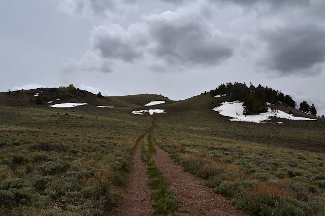
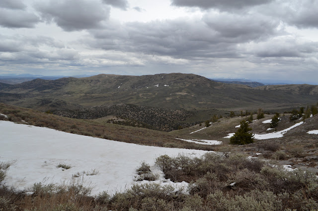
That little thought that I may as well climb something starts to creep in again. I may be turning into a proper peak bagger. As I get nearer to the bump I chose, one of the bumps ahead starts to look like it could be the high point of the ridge. There is a spine coming down from Mount Hamilton to it. Checking the map a bit more carefully and with a little more to match up, it seems to agree. The high point is not much further. As I go around a patch of snow on the road, it does not look like there are any tire marks but there do seem to be some old footprints. I wonder who else is hiking this area.

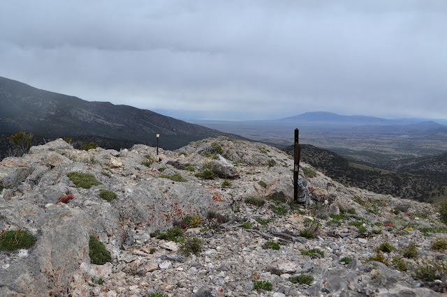
There is a little more snow as I go. I peek over one little crest to see how far it is to the top, then cut across a high spot while the road dips downward. There is a sign for a "dangerous mine", but all I can see is a snow patch with a bit of a depression. A vertical shaft hidden in the last of the snow. The road stops at another prospect just short of the peak. At the top, there it is, the sudden new views.


Without even my rain coat, it is cold up here. I try to take it in while snapping pictures quickly, then retreat the way I came. This time I follow the road as it dips and find a junction for where it drops back down to the west. That is definitely not my way back. I follow the road some more and as it curves away to the west, I follow the ridge. This one, too, has many old stumps. I pass by many more prospects, eventually not even marked as dangerous, and many claims, because some of these artifacts are not quite as old as the 1860s city of Hamilton.


There was no road over the top that I missed. The one spot that looks like it might have road coming up very definitely stops just before the ridge. I will have to make my own way down the other side, so I just pick a spot that seems less steep. The stumps follow me down even in places that would never be part of a fuel break. The whole area must have been denuded of trees when the mining was in full swing. Something has to fill the kilns to make the charcoal, so why not the sparse old trees barely making it on a high desert mountain? The very biggest trees today, which were probably little and ignored trees 150 years ago, are not quite so big as some of the stumps.

Progress down the hill is rather easy until the very last section where there is a large mine site. Between the huge vertical mine shaft with tunnels branching off twenty feet down and all the rubble removed from it sitting on the hill, it difficult to find a path until I get around to the other side. From there, a path has been made. At the bottom, I look back at the bright red danger sign beckoning for visitors. It looks familiar. As I glance across the road, there are my footsteps.

I recognize the sages as I pass where I came down from the first little peak. It should not be far now. There are the remnant walls of some small rock building on the right. There are quite a few mines along the way. They become larger as I go and have a new sign: "bat habitat". The gate on these is much heavier. Saving bats from a high probability danger due to careless people is probably a worth a little more effort than saving people from putting themselves in a low probability of danger. The people are informed, somewhat.


As what should be a short walk seems to go on for well over a mile, I am double guessing my route again. Apparently that road did not really exist the way I thought it did. I look for a spot where the ridge is short as I find myself getting just about as far south as I was on the peak. At least it is a little warmer down in the canyon where the wind does not blow as much. I am about to go for it as I turn a corner to find something very interesting. There is an actual tin shack. There are a few places locally named for them, but none of them still exist as far as I know. Of course this one has its own mine just outside one door.


The find of the old cabin has lifted my spirits and made me feel like at least it was worth coming this far from where I was hoping to be heading. I still go trotting up the drainage on the other side of the road to see if it really is a low spot. It certainly seems so until I get distracted by some more metal and wood that accompanies more mine shafts. This one has tight bars like the bat caves, but no sign.
There is a road just the other side of the mines. I suppose it was probably about to give me what I wanted after all. There are a series of closely spaced forest boundary signs leading off from a land corner marker rather pointedly placing the mines on the forest side. I turn to follow the road up the ridge a little sorry to give up the little bit of protection from cold wind that it offers. The road follows right on the ridge.

A very mangled, overturned car rests beside a junction. That road heads down into Hamilton. I can see the cow ponds down there. By this time I am having no patience with following a road around. I want to see my car and walk directly to it. Those ponds were far south of where I parked. Ridge walking will be far more direct than curving around the side. Cold? I do not care. Wind? I do not care. I can duck into the lee side of something if it gets to be too much. There are a few flakes dancing around me but nothing short of thunder will drive me downward. The area looks to be popular with dispersed campers and once had another stone building. I scare up another badger. They do not spin their tails around while running the way marmots do, either. As I continue, there is another road down into Hamilton. This is no more attractive to me. What there is left of road on the ridge seems to dwindle away as I continue on it. The evidence of prospects and mines, including a toilet seat because it is always nice to have somewhere to sit, continue.

From the top, I can see my car tucked in on the side of the junction of two thin roads, one leading right up into the valley below me. That is my route, through sages and grasses and ever increasing evidence of cows grazed in summer. I do not hurry, it is still cross country and important to pay attention to how I place my feet.

Halfway along, there really is road. It does not get much use, but is easy enough to hike. It probably connects with, or is, that last road I snubbed on the way past and would have likely been an easier hike back.

There is a little water in the middle of the valley, probably from a nearby spring. It is the first water I have seen today that was not falling frozen from the sky and it is just a few feet from the car. As I get there, I quickly grab something puffy to pull on before trying to figure out how exactly to get this thing safely turned around and back to the light duty road. Upon some cozy and warm reflection, it is not so bad as I felt it was when I parked and I am quickly moving to check out Hamilton and Treasure Hill again. Unfortunately, there is a thin, slightly deep creek crossing the road that looks like a good place to get stuck if I push it, so Treasure Hill was not going to happen anyway. It was about time for a slightly epic hike anyway.
©2017 Valerie Norton
Posted 31 May 2017
Liked this? Interesting? Click the three bars at the top left for the menu to read more or subscribe!


Comments