Big Rabbit: Villager Peak
Anza-Borrego Desert State Park
Click for map.
DAY 1 | DAY 2
The hikers gathered at just the right crossing of Truckhaven and S22, the latest coming in at midnight, to camp and get a mildly early start in the morning. Who would have thought the state park would allow dispersed camping? Just have to keep it within one car length of an established road. I give my banana pudding* a nice, long shake and put it aside in the cool morning air to refrigerate before carefully examining my foot for even the slightest glimmer of pain. No motion seems to set it off, so I get to wear my trail runners. It makes me feel safer to have a bigger range of movement on a wild "trail". I get some hot chocolate together to go with the banana pudding and scarf down half of it before getting a rather loud full signal. I head over to the actual meet point. We get signed in and extra sure that everyone has enough water. My brain keeps grunting that this will be a particularly heavy pack until a change of perspective. I have often gone out into the Sierra with 20 pounds of food about about 5 pounds of water. Swap those and it is about what I have today. Nearly 20 pounds of water and about 3 pounds of food. This is a perfectly ordinary pack and this weight will disappear faster.

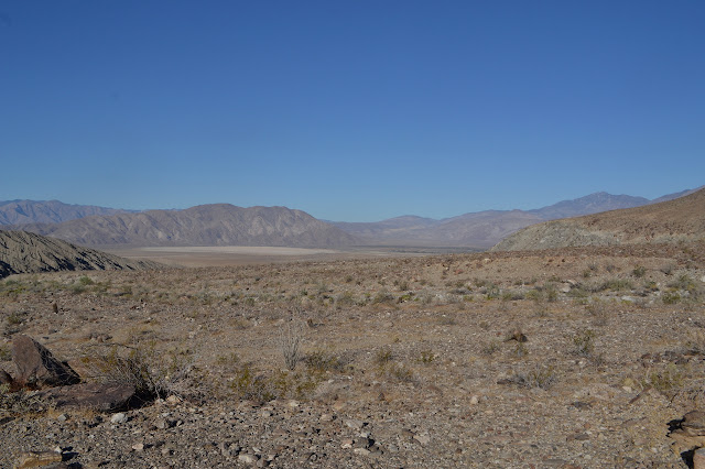
We start off across the flat desert on a well established and initially very sandy use trail. It is glaringly devoid of the slot canyons I was hiking past yesterday and was expecting to see more of. The scattered rocks look rather volcanic. There are more hints we are walking over different geology as we pass by ocotillo that is bursting out with enough leaves to hide the wicked thorns along their towering branches. We cross a wide and shallow wash just before we start our climb among granite. That is definitely different from the sedimentary rocks yesterday.


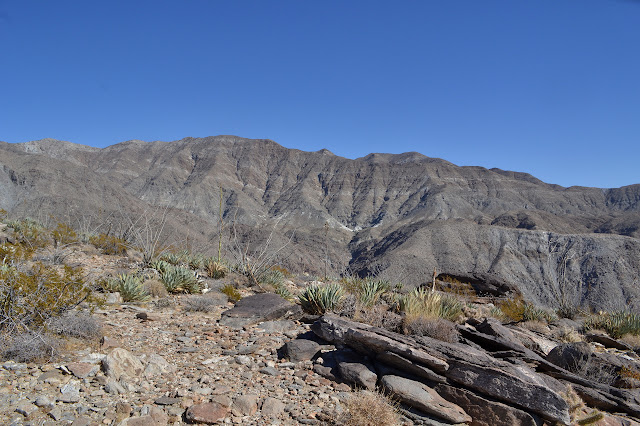
The climb does not seem to last that long. Above is another big flat, though nothing like the desert floor, with a well spaced garden of fairly gentle desert plants and some cholla. The flat only last so long and then we are climbing again. There are more flats, but each is a bit smaller. We seem to leave behind the few pencil cholla and barrel cactus as we go, but gain some agave.


As we take a rest and start to feel the temperature creep up, someone mentions it is supposed to be 85 or 90°F down in the valley today. Most of our hike has been at a rather perfect temperature, but once or twice we have started to feel warm and climbed out of it. It makes one glad to be going up, even if it is working hard hauling a pack that is at least half water by weight.


The rocks change back to the sorts of volcanic rocks that cool closer to the surface mixed in with ash and pumice. Further up, it seems metamorphic with some lovely stripes running through. Meanwhile, the plants gain a little more variety with the addition of mojave yucca and juniper and pinon pines, but the ocotillo has been lost. Smaller plants are more common too. There is dried out buckwheat and something structured all too much like a tumbleweed. Eventually, we get a new view out over the Coachella Valley and the north end of the Salton Sea. The misty south end had vanished fairly early on.


The rocks change again back to granite as we get close to the top. There are some large areas that would be good for camping and clearly have been used for groups like ours before as we approach, but we do not stop there. We drop our packs off at a flat just east of the peak then climb up the last few feet to claim it.


We pose and sign and generally poke around and look around before deciding to drop back down to get camp set up before it is dark. Set up is not much. Most of us have left the tent at home. There is a small breeze blowing, but it does not seem like it will be a problem. The peak blocks it for the most part. Still, it is cooling quickly. My jacket when first put on was briefly a bit warm, but soon became just right. There could be a bit more enjoying the sunset as we cook up our various suppers. Most of us neglected to take advantage of the fact that dry foods are not saving any weight when we have to bring up all our water too. There are lots of pastas and one freeze dried packet. Once it actually gets dark, we quickly sort our gear into hopefully mice safe piles (and apparently there really are a few mice) and fall into bed quite quickly, but not before a few rather impressive fireballs fall from the sky for our oohing and ahing pleasure.

We watch for more meteors as we sit tucked in, anticipating almost 12 hours before morning activities. It is way too long and way too early, but we are surprisingly tired. I am not comfortable enough to do more than drift in and out of sleep as I watch Orion climb to a point almost overhead. I finally break down and gobble down the last of my banana chips, which seems to warm up the unhappy bits of my legs and feet and suddenly proper sleep is obtainable.
Continue on to the next day ⇒
*Banana pudding. I was doing a more complicated pudding with dried fruit and nuts and such, but was only really liking it with chocolate. It was too much the same flavor each time. Now I am trying some Jello pudding. I have enough pudding mix for 1 cup (1/3 of the package for the banana) and 1/4 cup Nido, then fortified with chia seeds (1 oz, ~3T) and shredded coconut (1 oz, but might be a bit much). Throw it into your favorite Talenti/peanut butter/screw top Ziplock/bag if you must container with 1.5+ cups water (the chia seeds will take up a bit, so more than just enough to reconstitute the Nido) and shake (that is, "whisk") for 2 minutes. It is a bit more work than the other. Refrigerate 5 minutes. Scoop into mouth. Beware: Nido can turn into a bit of a brick under vacuum packing.
*photo album*
©2017 Valerie Norton
Posted 23 November 2017
Liked this? Interesting? Click the three bars at the top left for the menu to read more or subscribe!


Comments