Western Plateau, Elliott Peak, and Hawk Canyon
Conejo Canyons Open Space
Click for map.
After missing one, I am out for another round of trails for the Conejo Open Space Challenge with geocahers. Today, our required trails are a pair of short pieces in the Conejo Canyons Open Space: Elliott Peak and Hawk Canyon. They are joined together with a long and elaborate loop that goes for an estimated 8 miles. I arrive a bit confused about where to start. We are only five strong today and Matt says I am in charge because I was the one doing the little bit of pushing to make sure everyone remembered there was a hike scheduled for the day, what it was, and determined a meeting time. (I did all that for the last one, too, and was not even going.) This is unfortunate because, as I say, I seem to be a bit confused about where the start is. I promptly compound it all and get somehow more confused and we go ahead and start down a different trail which will get us to our loop and does mean we have a nice parking lot to leave the cars. It has "do not leave valuables in cars" signs and everything. But it is definitely the wrong start. Oh, and I seem to only have the telephoto lens for the camera even though the normal, wider angle, one should be quite dry by now.

We start off downhill, but that is the way of it from this area. We will just have to finish the day climbing. As we hit the bottom, we hit one end of Hawk Canyon, one of the required trails for the day. And after way too much discussion decide to leave it for later in the day since it is a nice, shady area. If the weatherman predicted well, we will not really be too worried about that, but it is so sunny that it is hard to believe it will remain cool all day.


We turn up a trail to find it is part of our planned winding romp through the western plateau. Oh, and the mutiny starts (or would if we had a leader) as Matt takes the shorter route along the road saying it will all meet up again soon. Which is true. We relish getting off the road. Also, I had already had found the geocaches along the road, so it is nice to finally get to claim a find.

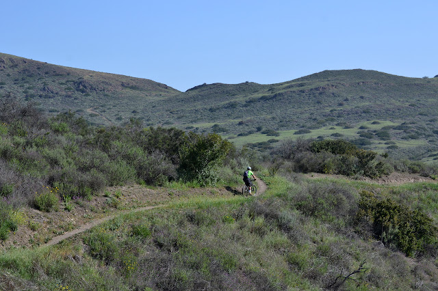


The group collects together again briefly, but then diverges again. One says there are caches off that other way he wants while the other says he hates to lose elevation already gained. I look around and see no climbs or 1000 feet or anything to get one worried about a little gain and loss here and there. We wave expecting not to see them again. They will basically be shortcutting a winding bit.


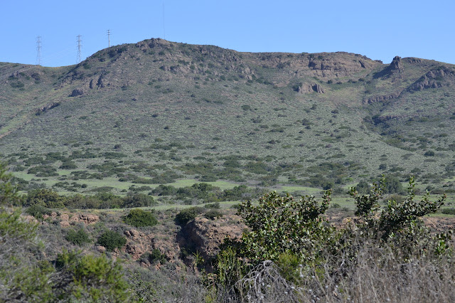
We finish our longer wander through the plateau and head high on the utility road the others already passed along. Now the pieces of not so distant city come into view. We can see a pair of figures hanging out up on "Big Eagle's Roost" as they like to call it. It may be Elliott Peak formally, but while he was geocaching, he was Big Eagle.


We make our way slowly finding each geocache just found by the others. They are still chatting and pointing and enjoying up there on the roost the whole time. We very nearly have the band all back together as we touch the top ourselves. There is a bit of scrambly rock to get up there and one stayed behind for that. After signing the geocache and peak register with a big eagle on it, we head down again as one leaderless group.


At the bottom, we are at the far end of Hawk Canyon. Of course, now it is after wandering around for a few miles and there is little desire to actually do it. There is a distinctive lack of actually going for the challenge as opposed to having a handy hike calendar for every other Sunday. The guys all decide to hike out the ridge while I decide to take on the canyon trail before also hiking out the ridge. The ridge is the way we meant to come in along. If I had not been so incredibly confused about how to start, that is. Anyway, I wave to them, really for good this time, and head off into the trees.

I thought the challenge trails were chosen because they are underutilized, but Hawk Canyon has lots of people wandering along it today. From the north end, it drifts very gently up. It is so gentle that I check the creek flow to be sure. There is not much, but there is water in the creek today. Also a car. It just is. There are others about, too.

After hitting the far end of the canyon again, I turn around and head back. I spotted another trail about halfway along and as I pass it again, I cross the tiny bit of water to take it back instead. It parallels the lower section so that I do not have to follow exactly the same route. This one follows above the trees in the grasses so that there are more distant views.

The trail also has some evidence of surveyor having come through, but a steep short trek of a hill yields no markers, just old wooden stakes. As I hit the trail I first followed into Hawk Canyon, I follow it again to take the very end of it. The trail to the right was well traveled, but the trail to the left is very thin at the junction. I follow it out to another road, then take that to the ridge route up and out of the canyons following where the guys went a while ago.


At the top, there is no parking next to the trailhead, but there is some a little further along the road and on one side of a side road nearby. The lot is a short walk down the side road. It has quite a few more cars in it when I finish.
©2018 Valerie Norton
Posted 5 May 2018
Liked this? Interesting? Click the three bars at the top left for the menu to read more or subscribe!


Comments