Red Mountain Lake, Blue Lake, and Fish Lake
Six Rivers National Forest

Fish Lake has an island of trails that exists in a section of forest that is a tangle of roads. Some details of these trails as marked on the Forest Service topo seemed suspicious to me, but no one had bothered to place them on OpenStreetMap to help suggest what reality might be. Why are there two routes up to Red Mountain Lake? Why does the loop around Blue Lake extend well past the road? The only trail I was really certain would exist is the loop around Fish Lake. The lake has a campground and is stocked which suggests there would be plenty of users for a lake looping trail. So, for the public good of improving the map, I headed out to the campground area! Not to mention that the whole collection of trails looked like a good day's hike in a place I haven't been. (I have been to nearby Bluff Creek Historic Trail.) Although the seasonal Port Orford cedar disease closure listed for the whole of Bluff Creek Road (NF 13) goes until June, the Six Rivers site for the campground assured me that was open. The road was open at the highway, but I met locked gates at the junction with Fish Lake Road.

Change of plans: hike the road to the closest trail segment, which is a seemingly random connection between the trails at Red Mountain Lake and road. If I miss that, there's always the trail around Blue Lake to find instead.

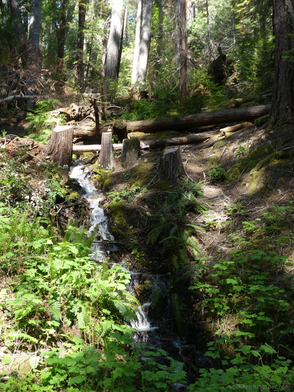
I was enjoying the little cascading creeks and numerous irises along the edge when I found I had missed that first trail. Giving it another chance, this time with more attention to looking for it, it wasn't that hard to find. A tall wooden post stands in the middle of an old, blocked road right where there should be trail. It looks like it might have said something before.


The road wasn't long and ended in a turn around that became a disused camp. I looked to the map for the clue that the trail turns left and picked up something with encroaching branches and the odd thin trunk down across it, but it was increasingly obviously trail to the junction with the Blue Lake Trail.


At the junction, I went looking for Red Mountain Lake. It wasn't that impressive, but once I turned left to go toward Blue Lake, I found that I'd been looking at a disconnected pond next to the lake.


The trail starts climbing once it leaves the lake. Eventually, I could hear water running, then with a dip and a bridge the trail crosses and starts to zig-zag upward to meet the paved road again.


I arrived at the road again beside a gravel parking spot. To my left, a much larger graveled parking area and fence marked the rest of the trail. A sign warns that there is an active infection of Port Orford cedar disease behind it, which is particularly worrisome when soils are wet. They aren't wet now. The trail around Blue Lake is graveled and has a boardwalk section.


I came to a spot where people stop for a while by the lake. It looked like trail extended to either side from it and I chose to head out around Blue Lake to the right. The trail gets less developed as it rounds the water.


I saw quite a few flowers on the way including a large number of fairy slippers. One caught my eye because it seemed to be wearing a mustache. Unfortunately, I scared it off before getting a picture.

Instead of coming back to what I figured would be my lunch spot, I suddenly found myself at the road again, but on the other side of the outflow stream. I had to walk back over and take the gravel and boardwalk again to return to the little spot beside the lake.

After lunching, I headed off for more lakes. First back past Red Mountain Lake.


As I left shallow Red Mountain Lake again, there were small trails going places, but not for very long. To follow the main trail, I had to go over a rather large log. The trail split just where the Forest Service map said it would. There really are two trails between Fish Lake and Red Mountain Lake. I picked the left one since it looked less used and overgrown trail tends to be easier on the downhill.

It wasn't overgrown. It crosses the stream on a bridge, which keeps you out of the active infection that is expected to flow down with the water, then up to a ridge crowded with young trees. Then it heads down. Except for nearly having a view, this wasn't a very interesting trail.


There's some faint old roads before arriving above a current road that seems to serve for maintenance of the campground water supply. I say above because there's a stack of three large trees on top of the trail just before the road. I made a different way to it and found the trail again on the far side. That drops to a legal road suitable for passenger cars, at least according to the outdated data available to the public.


I popped over on the road to see how the other trail looked on this side. Besides having a tree down near the junction, it looked fine. Then I returned for the last piece of trail down to the Fish Lake Trail below. Other than a "trail" sign, that part of it is mostly gone.

The loop trail below was quite obvious as I arrived. A little less overgrown than the last half mile or so. And there's bridges on all the incoming waters. Well, almost. I turned right. Had I turned left, the first would have been bridgeless. There wasn't much view of the lake considering how close the trail is to it.

The best view of the lake is gained by walking down the retired dirt boat launch, although there's pretty good views along the trail after that before it ends at the new, paved boat launch.


At the end of the trail, I found that this trail is for foot only. All good to know for mapping it. The launch was more to note. The Forest Service hadn't mentioned that on their map.

My plan was to walk the roads around the lake until finding the other end of the trail, then head back up the second trail. So I walked. There's a nice big gravel lot for the launch and the campground road system has changed and been paved contrary to FS claims. All noted for mapping. Oh, and one of the ducks that didn't wish to be photographed on the lake decided it was fine on a high log above the secondary outflow.


I glanced around the signs. It's just $10 to stay in the campground because there's no concessionaire. Lovely while it lasts. I wandered over to the day use area, which also has a pretty good view of the lake along with a bench and picnic tables.

Someone has left a row boat in the picnic area, but no oars, so no wandering about on the lake for me. I headed off to find the trail again.

This end is not only labeled foot traffic only, but also warns about more active infection of the Port Orford cedars. No surprise since it tends to flow with water and the main input to Fish Lake flows out of Blue Lake.


I continued along past that single crossing without a bridge (small enough to stay out of the mud) and past the first trail to the second. Since Blue Lake Trail had been so bad, I expected Red Mountain Lake Trail (name found on the S1 app later) to be better. It has a post to mark it and good tread, but the trees on it are even larger.

Once past that and the tree by the junction with the road, it was all pretty clear. This trail follows more closely along the stream, so the area is more moist and there's more growth of the nearby plants. And there was one more very small tree down. Otherwise, it was all quite simple to follow. Well, there was one spot that looks like it got rerouted after a bunch of trees came down in a spot and the new trail hasn't become very obvious.


Short of my arrival at Red Mountain Lake for a third time, I noticed a ribbon of grey through the trees to my left. It wasn't far and I cut across to it, encountering a use trail about halfway along. Animals or others had done it before me. I wandered a little way down before turning back to walk back to the gated intersection. It was still earlier than necessary to return, but weather had turned to cloudy and cold.


So the map was largely accurate. All those trails exist although they don't quite do exactly what is claimed around Blue Lake. Also, the road around Fish Lake is not a road anymore. And there's some extras. I got the area roads corrected before going and rest of the mapping done before the writing.
*photo album*
©2025 Valerie Norton
Written 6 Jul 2025
Liked this? Interesting? Click the three bars at the top left for the menu to read more or subscribe!


Comments
Forest Service maps are beyond suspicious. I think that you know about my Web site. That's where you're going to find accurate trail mapping for the vicinity of Orleans. KlamathMountainTrails.us
As for OpenStreetMap and other sites where people contribute tracks, they're ALL just collections of various people's opinions, and you know very well how uneven and conflicting those opinions will be. None of them are properly edited by any one knowledgeable person. So I'm not playing, no thank you.
But thank you for the condition reports!
So you sense some sort of ulterior motive behind mentioning the mapping? Hum. One does come to appreciate the billion+ dollar a year operation that is trying to map everything and why some ranger districts aren't quite as good at it as others. Still, it is a complete package that includes how to get there, so it's going to get looked at. (Google, it happens, is not just missing the trails but will try to get me to Fish Lake over several miles of long decommissioned roads, so even worse as a complete package.) Really, the inaccuracies on the FS map here turned out to be just a quibble.
Anyway, I find OpenStreetMap an interesting experiment. It's not a place to contribute tracks, although there is a spot to do so. Currently my opinion on where that trail around Fish Lake goes, and I trust that mostly. I've learned to encode a bit more than "trail here! there's a trail here!" when I do it. I can say "and it's a little bit faint" and if it is thickly overgrown or there's quite a lot of trees down on it. I've learned to help out my fellow mappers by mentioning why I think there's a trail there, be it my somewhat iffy GPS, the Strava heatmap that can be better but doesn't always capture the curves, or some line I found on a 30' USGS map from 1910 that is probably badly placed and would have vanished by now if it was ever really there but I feel some desperate need to share. (Not my fault if AllTrails renders trail_visibility=no the same as =excellent. That's on them.)
But it is definitely a collection of various people's opinions. If you don't want to offer yours in that format, you don't have to.
The really old topo maps tend to be "schematic." The registration of the depictions of features with actual latitude and longitude locations can be very poor. Whole watersheds might be shown draining the wrong direction, etc. The mapmakers did very well with the simple tools available to them at the time.
By and large, the pinnacle of quality came with the 7.5 minute series hand drawn through photogrammetric methods. Even then, serious errors could creep in. The process of recognizing precisely where to draw contour lines was imprecise, and a mapmaker could easily misinterpret photography and place a stream in the wrong location, for example. The new machine-created "U.S. Topo" series is crap.
I continue to appreciate your many contributions.