Eclipse: Strawberry Mountain
Malheur National Forest
Click for map.
DAY 1 | eclipse | DAY 2
The original plan for eclipse viewing was a campground in Portland and an hour long drive to get somewhere to see totality on the day. Trouble was, the expectation that traffic would move in that direction quickly enough seemed like a poor one. This was compounded with the worrisome prospect of fog near the coast. And then Jeff demanded an alpine lake. After an initial thought of Mount Jefferson (oh, look, it says "closed" under current status just because it is on fire), we found a lake that, while not quite alpine, was rather large and well located to be without obscuring smoke. It also has a nice peak nearby. I figured, we get in at least a day early and settle in by the lake, bag that peak and get a look around to decide where is the best viewpoint for eclipse watching in the morning. A perfect little trip.
We stopped in the local ranger station for a map, of which they happily had a few, but found out the road to our trailhead was parked up from the end to the forest boundary to the point where they were starting to worry if they would be able to get a fire truck out there, so they were stopping traffic on that one. We thought about it for a moment and decided we were just as keen on them being able to get a fire truck up their roads as they were, so took the recommendation to go around to a south entry. And then we stopped by Trout Farm Campground, favored as a water source by the rangers because it has a piped spring spewing "the best water in the forest" 24/7, and found a campsite occupied by a single bicyclist who was willing to share for the one night he would be there. (We were not the first to ask, but it turns out that driving up in a lifted pickup truck and shouting, "Hey, you aren't occupying that whole site!" is not a good way to inspire someone to want to share space with the shouter.) So our plans for starting into the mountains got delayed.
Jeff decided he had all he wanted for the next few days at the campground, but we could still go up and do our silly hiking thing. He could drop us off at the southern entrance and we could meet him at the waterfall late the next day. He did still want to see the lake and the waterfall. With the delay, the rangers had got around to stopping traffic going up the south way, too, but since we were not planning to leave a car up there, we got to go past that road block. The pair stopping traffic looked suspiciously like some rangers who had stopped by the campground spring pipe that morning to grab water. The amount of cars at the trailhead is astounding. This will be a wilderness experience to rival that of going up Whitney. Wondering something? There is always someone nearby to turn to and ask. Need something? Someone with it will be by within 10 minutes.

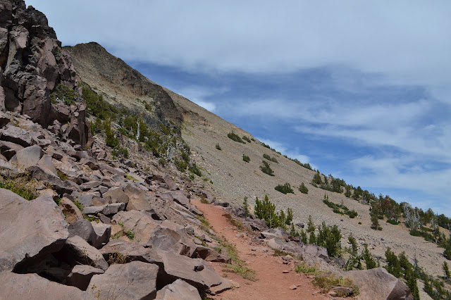
Although we are starting at Roads End, the road does not actually end for another half mile where there is a trail into some lakes. I really wanted to do the loop through there, but the hike out for tomorrow would be too long. As we start hiking, it is clear road used to go this way, too. The sides are marked with burn. First it is a recent fire from just a few years ago, then it is an older fire from 1986, I believe. Both were devastating. We were told at the station that most of the western portion of the wilderness had burned and that some of the trails were severely damaged and some parts even lost.


Signs along the 395 advertised our location as the Oregon Outback and it would generally be dry, but this area has a lot of springs. The map shows one down below the trail, but as we attempt to avoid the mud and enjoy the purple monkey flowers, it clearly is a little closer than shown.


We come to a ridge that looks, at first, to be a lookout point. Look a little closer, and the trail along it becomes visible. A sign is nailed high in a tree marking something as the Onion Creek Trail. Nothing else is marked. The ridge looks dry and burned, but also like good viewing with a better chance of some wilderness character. There are a few that have gone this way, either for the short walk to get away from the crowd. We have our eyes on the peak, so keep to the well worn old road curving toward it.


The old road dwindles to a trail as it curves around toward the mountain. I am almost expecting to see it getting freshly established with all the feet on it for the weekend, but it was clearly well established and easy to follow even before the sudden and crazy influx of people. It is surprising how many of the trees are still standing as we pass by the older burn area, but quite nice when we pass the junction to drop down into the meadows and get to where we can see trees that are still full of green.


Past the junction, there are even more people on the trail out to bag the peak. Going for wilderness high points, forest high points, county high points or just nice high point with a trail up it, this one ticks all sorts of boxes so there are plenty of people out to see it while they are here.
At the last junction before the peak, there is a little commotion by a viewpoint. Someone is making sure the people passing by know there is something to see out on the northern ridge of the mountain and the something to see are mountain goats. There were about a dozen out by the snow, but now there are only about four.


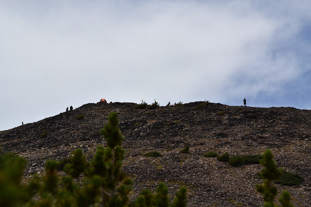
It is just about 300 more feet to the top from the junction. The trail goes up in some nice switchbacks. There are some older, steeper routes that look like they will never quite go away. There are certainly plenty using those today, but also some rebuilding the rocks that direct traffic to the less steep trail. I go the easy way. A few extra steps and turns do not hurt me.
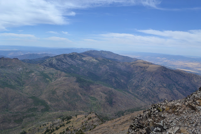


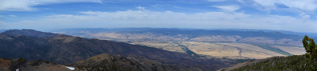
There are distant peaks that were not visible just a little lower that can be seen from the top. To the northeast, they look like they might even have some snow on them. The distance is great, it is hard to tell. We get to pondering where to camp out. The top is largely a knife edge of sorts. There is one tent up at the north end somehow tucked into the single somewhat flat spot over there. The south has a few spots that people have put tents. Most obvious is the old location of a lookout. A few cables still remain of it, but it was removed many decades ago. There are a few more to the southeast along the slope. There has been a bit of rock slumping down into those. We ultimately decide to worry about possible wind and drop back down to the trees below. They may be only slightly taller than ourselves, but they offer a bit of shelter.

There are quite a few already camping down in the trees. Looking over the map, I thought it looked like there was a lot of room, especially if one continued a little further down Onion Creek Trail as it starts down the ridge. There is a wide shoulder area for a quarter mile. We are able to find a spot near the junction with agreeable nearest neighbors from Switzerland, but before setup, I want to check out the rest of the area. There are a lot of people along the way, but they vanish halfway to the end of the shoulder. There is still a lot of space for us, but upon return, it is clear we will not be moving.

Worryingly, it clouds over for the evening. The dreaded wind does come up and blow for a while, but quits again shortly after dark. No moon. That is gearing up for the big event and already hanging out very close to the sun.
Continue reading ⇒
©2017 Valerie Norton
Posted 3 September 2017
Liked this? Interesting? Click the three bars at the top left for the menu to read more or subscribe!


Comments