North to South: Bishop Pass and South Lake
Kings Canyon National Park
Inyo National Forest
Click for map.
DAY 1 | DAY 2 | DAY 3 | DAY 4 | DAY 5 | DAY 6 | DAY 7
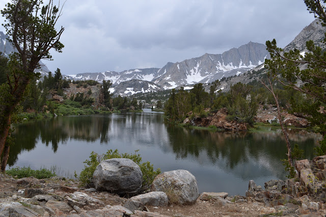
Two more days in the plan, but probably only one more day for the execution. I expect to stare at one more mountain that would be a perfectly reasonable climb, and then not go up it. The climb would make it late for getting out, so staying one more night would be nice, and the extra day would make time to go up one more little peak on the way out. Or I can just hike out today. I have minor, but unfounded, worries about leaving the cats with a first time carer for a week. The one needing pills can be a nuisance. So I may bail on the plan. Meanwhile, out in the Dusy Basin, it is looking like a very nice morning indeed.


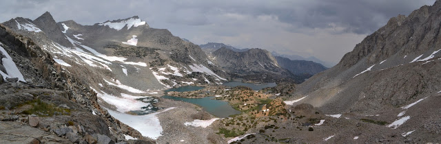
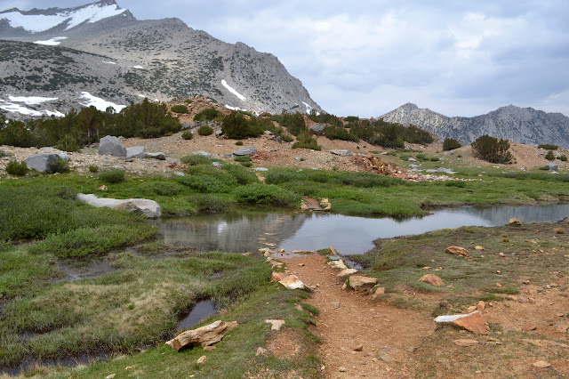
There are lots of lakes, creeks, ponds, and even an automatic snow sensor along the way. There is only a little bit of snow to deal with on the way up the pass.

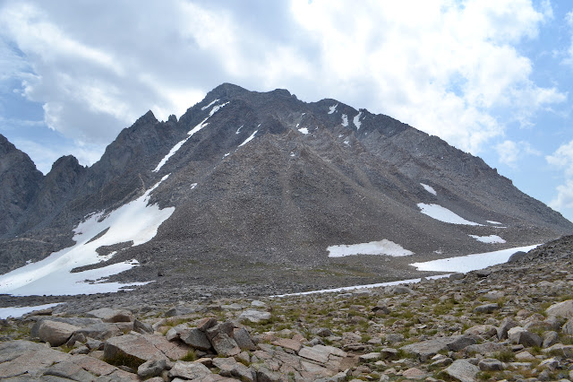
The pass has a constant backdrop of peaks as I climb it, so the top comes as a surprise. There is a PCT through hiker telling stories with one group at the top as I arrive. When they leave, she comes over to me, so I tell her about Mount Agassiz to the east. It rises about 2k feet from the pass to top out at nearly 13.9k feet to be California's 21st highest. The approach from here is considered class 2, but I am not climbing it today. Upon telling, her body language seems to say I would have a climbing partner if I chose to go for it. The weather is uncertain, but looks like it will hold for long enough and when it breaks, it will be a long way from here. She says she is just poking around and resting while getting over a cold, but she definitely has energy to spare. Nearly everything is falling into place for a reasonable try, but I stick to my previous decision. I am not climbing the mountain today. If I had taken her up on the unspoken offer to accompany me up, it may have turned out to be an illusion anyway.
She heads down, back to her camp by Chocolate Peak, taking an unexpected direction. Snow to the right looks more likely to have the trail as it seems to slide down a rounded valley. Snow to the left looks like it goes out to a ledge for a lookout. Many have gone to the right, but there are some trails to the left too. I figure she just came up this and probably knows better where the trail is and follow to the left. Sure enough, there is trail over there. Also lookouts. Surprisingly, there is not much snow on the trail on this side, either.

It is a really good thing this trail has no snow on it. The route down off the north side of the pass hugs into rocks so steep, the switchbacks seem stacked up on top of each other rather than offset a little.

Once down off the steep pass and into the benches and lakes, things start to get a little soggy. I watch a pair head off trail to pop over the first puddle on a thin bit of snow, but figure through makes more sense. Surely, feet are just not meant to be dry. I find the same pair fiddling with their shoes not too much further. It seems like far too much trouble and the water is feeling practically warm now as I splash through.


Chocolate Peak stands out in its off color. It would have been the little peak to fill out the day tomorrow. Some day, it will probably become a delightful little start to another trip.

I had expected maybe a little fewer people on the way down, but there are still plenty and soon I am in the range of day hikers on reasonable hikes. They try to confuse me by asking if they are nearly to "the lake" while standing next to a perfectly nice lake. Closer to the trailhead also comes with nice little bridges crossing some of the waterways.
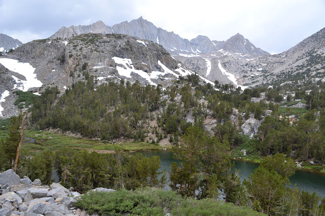


The day hikers get really thick below Long Lake. There are even big family groups with lots of kids that look more like half a family reunion than a hiking group.


South Lake comes with a few boats out on the water and a few motors pushing them along. The trail still has a lot to drop as it passes by, so there are some good views back into the wilderness.


The end of South Lake marks the possible start of road hiking, or hitchhiking, to get back to the car down at the Tyee Lakes Trailhead. I have noticed the line of trail that parallels at least half of that distance, though, so as the trail dumps out in the parking lot, I keep right to something a bit overgrown. It is getting slightly overgrown, but it is with bright flowers. A woman with a large camera taking pictures of them looks at me with accusing eyes as I invade what was her private space along it. This comes to a road from the other side of the parking lot, but it turns into trail quickly enough. There is only evidence of horses passing as I climb upward. Why upward? I should be going down. But this connects to the trail to Green Lake and then drops down. To say it parallels the road is not exactly accurate.


It rains a bit as the trail turns downward to connect with the resort below. I followed this trail when we climbed Cloudripper and remember some of it. Mostly, I remember that it was full of flowers. There are not quite as many as then, but still lots to look at. I also sort of remember that I should try to go up near the start of the resort to have easy access to the last bit of road hike for which there are no options. A track by the store looks steep and unofficial, so I wander looking for something better. Maybe I remember incorrectly.

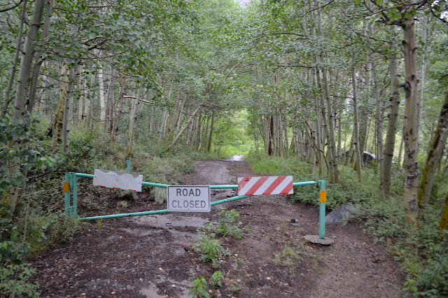
The trail comes to the stables at the end where the horses are huddled under the trees. I was right the first time, I needed to grab that trail up past the store to access the road. Here there are a bunch of brochures for trail rides and a long way back. There is also a well established trail down to an old road following the creek below. All I have to lose is time and the horses have clearly been using this route, so I try it out. Sometimes the pavement is completely overgrown with trees and sometimes it has vanished altogether, but there are plenty of horse prints about about three sets of footprints that follow trail along the route when this happens. One section is under a foot of water for over 100 feet, but it is slow moving and the trail below is obvious. It comes out at a gate marked "road closed" at the end of Willow Campground across the street from my car.
Busy road walk avoided by old road walk, and now I can finally be out of my wet shoes and socks.
©2017 Valerie Norton
Posted 31 August 2017
Liked this? Interesting? Click the three bars at the top left for the menu to read more or subscribe!


Comments