North to South: Evolution Basin and Muir Pass
Kings Canyon National Park
Click for map.
DAY 1 | DAY 2 | DAY 3 | DAY 4 | DAY 5 | DAY 6 | DAY 7
A lot of people have told me that Evolution Basin is the prettiest bit of the Sierras. There was even a day hiker coming up toward Piute Pass who said so. Today I will see it for myself. My shoes are not a lot drier after the night that seemed to have a bit of dew. My other camp sites were definitely a lot drier. It does not matter anyway. Crossing the tributary just up the trail while keeping my feet dry only lasts until finding the second, larger part of it. Who needs dry feet? And with the day's inaugural splashing, I head on to more meadows.

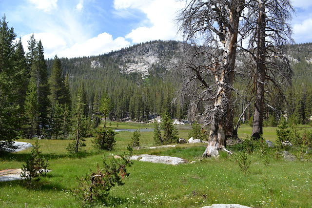
McClure Meadow is extensive and green and the creek sits within it like a long lake. I stand at the edge of the water for a while before noticing the flicker of ears in a nearby grasses. There is a small deer sitting behind it hiding.

Heading off, I check on the ranger station just to see that kind of place it is. It is a simple affair, but has solar electricity and a chair. There is a weather report for two days ago on the board with a note that the ranger is out on patrol. So I turn and continue to wander upward along the meadow and creek.
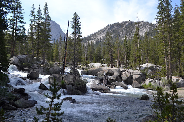
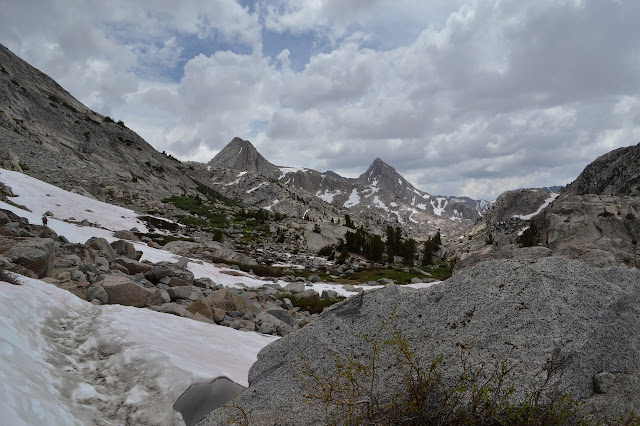
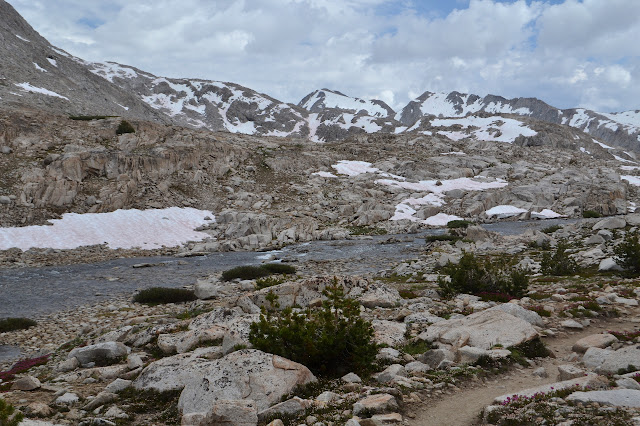
The trail starts to climb in little wiggles along a tributary on the way up from the valley to the basin. It is nice to have a proper climb for a little bit.
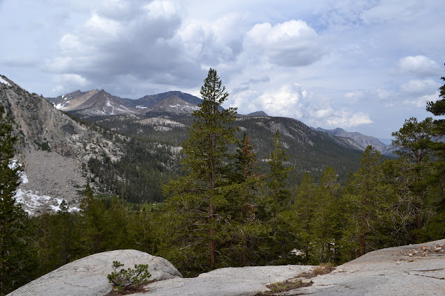
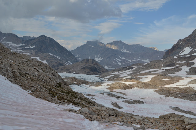
The trail levels out to wander between two ponds, then it is up and over one little rise into Evolution Basin. Huge Evolution Lake is the first of the lakes. The trail once went much closer to the lake and the track is still very visible. I am glad it no longer does. It is soggy most places and underwater in some. It even hopped along rocks over an inlet. Now the rocks are overgrown. On the other hand, where the trail is now has quite a bit of snow. None of it is hard to walk on and plenty have already to beat down a path.
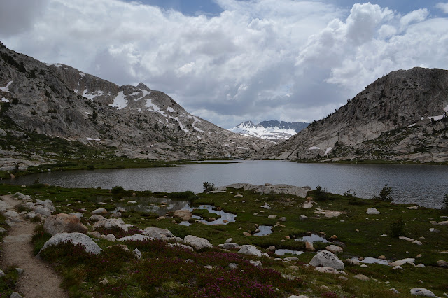
The far end of the lake is where trail builders decided that the creek is small enough to cross whenever needed for easier trail construction. Oh, and that it is needed now. There is one long crossing through the water, generally knee high and somewhat swift, before climbing to the next bench and lake. This one is not quite so warm, either. My feet hurt from the cold by the time I finish with it.


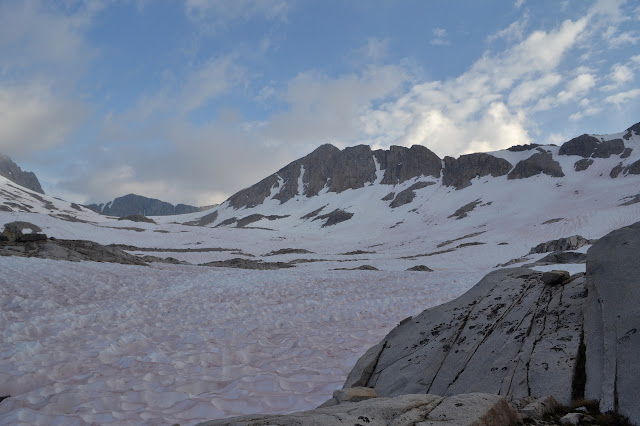
Up the next bench is my destination for the day. I want to cross over the creek and find a camping spot and then head on up Mount Huxley. It has a class 2 approach along this northwest ridge, but is otherwise class 4 as near as I can tell from online information. I was sort of hoping the ridge would be full of snow and dangerous looking for an excuse not to go up. It looks quite clear. The creek crossing looks wide and shallow with a consistent flow the whole way, so should be reasonable. With 2000 feet to climb, I should be able to get up and down within 4 hours and I have 5 to sunset. (Ruth, who I hiked with a fair few years back, uses the estimate of 1 hour per 1000 feet and figures she needs to get in better shape if she cannot keep to it. It can be a very good estimate although I tend to think it puts me needing to get faster.) The weather is not perfect, but it does not look like it will drop any electricity.
Except. Except my legs still feel dreadful from the poorly executed approach to Pilot Knob. And with that in mind, I feel like I really want 6 hours to get up and back.
Except. Except deep down I am sure I can make it. Darkness will not fall at sunset and the lower sections are probably fine by headlamp. Perhaps I should just give it a try. These things are very tough to judge with certainty.
Perhaps I am really not a peakbagger at heart. It is hard in this moment to feel like anything useful has been done if I try and do not succeed. "Do or do not, there is no try." Except that is false, Yoda. To try is to resolve to do even though doing is not certain. It may happen, it may not. It is only certain that if you do not try, it will not happen. Today, I leave Huxley without even stepping on his toe.

The hikers coming the other way tell me that there are no camp sites between here and the pass or at least all the traditional ones are currently under snow. That is not particularly interesting since I am sure I can make the pass. Besides, there is a camp site just 100 feet past our meeting, so I figure the determined person can find one.
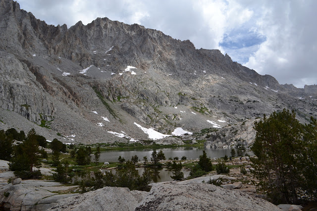
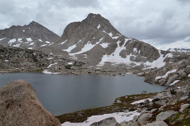
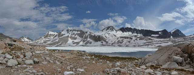
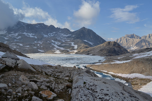
The trail crosses the creek again. There is a snow bridge option, although it is not entirely clear from this side that it is. I go for the trail crossing. The trail has been rather wet from thaw anyway, my shoes just got wet again a minute before from a little stream. There seems no reason to risk the snow bridge. Once my feet are in the water, there is a reason. It is now cold enough to hurt immediately. Getting to the lake, it is no wonder. The water is pouring out of a lake that still has at least 80% snow coverage.


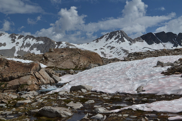
In spite of all the ice, Wanda Lake still has plenty of green where the ground shows. Shooting stars line the edge. A bee keeper told me they point downward after pollination, so the number I have been seeing old and still pointing up during this trip has me worried about the bees. I stop to toss a rock over to the snow and ice for no good reason except to maybe see it pop through and drop down. Sometimes we must have a silly moment. The first goes off in the wrong direction, but the second hits easily and sits vanished in the snow. It is only after examining the snow for a little longer than I notice the three frogs sitting by my feet not quite in the frigid water.

Above the lake, the trail gets pretty free with crossing the creek. Hikers coming the other way often make good sign posts, but I catch a couple coming down a very steep bit of bank to a crossing, then notice the trail making a nice and easy climb from the creek a short way north of them. They got misdirected in the snow. There is plenty of snow. It is easy enough to walk in in the current conditions, but still a bit harder than trail. My shoes are stained from the algae that lives on it. Initially, they match it in color, but over time it turns to an orange that matches the colors of some of the rocks.

The trail gets really hard to follow with all the snow and I start looking for the reasonable route instead. A track across the snow at a low angle above me looks wonderful. It is probably the winter route from those who were only looking at snow, renewed daily by those who just decide it is a good route. The hill between me and it is not bad, so I zigzag my way up and walk that.


There are two sites for camping right at the top and the hut to take shelter in should things get worrisome. It rather looks like things might get wet, at least. The wind potential at saddles is great and there is still a bit of usual hiking time, so I head down to Helen Lake below. There is not much indication of exactly where the trail is, just a rather steep and direct downhill route in the snow. It catches in next to a bit of trail going up some more, but down vanishes again. I just work my way down the rocks and toward the hints of trail below that the many feet stomping through the snow seem to have gone for before me.

It is time to find a spot as I reach Helen Lake. There is a big group setting up at the top of some of the rocks off to one side of the trail. It looks to me like a site around the rocks a fair distance from them. Being down in the rocks, I hope for a little more shelter from potential winds than they. There are no winds while setting up, but there sure are some rather good gusts once I have my little roof set. The first comes down the canyon on the side where the roof is low and it hardly notices. The second comes up with at least as much vigor, tucks up under the high edge, and shows off the weak link in my set up. The one line that is not tied to a rock with big rocks dropped on top goes flying. Setting up again with the stake with some rock support holds shortly, but then the stake gets around its rocks and goes flying again. This time everything is set out and I have to capture the rather light pieces of sleep system that are thinking of going on their own journey. While holding down tyvek, pad, quilt, and bivy, I am not quite ready to fool around with the roof again. Maybe I can just flip the bivy over to keep the rain off and settle into a slightly more sheltered spot. The sheltered spot is a depression with a gravel bottom. Hopefully it drains as well as it looks like it could.
That is not quite where the journey of the day ended, though. Those gentle looking rain clouds kept building and with it dark at least an hour, it did start to rain. After a while, I began to notice that I might be a little wet. Looking around the bivy, there is actually quite a lot of water in it, to be perfectly honest. There is no pooling outside, the puffy mat would keep some of that at bay anyway, but there is pooling inside. Looking around, there is a surprising amount of light considering it is night, overcast, and there are passes between me and any city light source. Where is it all coming from? And more importantly, what do I want to do about this water? Get things set up properly with my roof, including really good rocking on the one that kept getting away? Or maybe get everything stuffed in and climb right back up the last 400 vertical feet of steep snow and take advantage of that nice dry hut at the top? There is lightning. I can see the light from it play across the clouds. It is occasional and so far away that there is not even the slightest sound. There could be wind up there, but the rock would be a really good shield against it.
It takes a while as I look out on that mysteriously bright landscape to decide, but I go for taking advantage of the silly rock hut at the top. I pull on my rain gear, but not my puffy jacket. Everything gets stuffed in, definitely wet things in the space between the pocket and the bag while my quilt can go in its stuff sack inside. Once packed, I finally get my headlamp out and on. The rest of the landscape vanishes as the near becomes easy to see. Memory will have to serve for the general navigation. The big group seems fine on their rock top. One tent has a light on, but the gusts have not done anything permanent to these free standing tents. I hit the snow beside the lake and follow my tracks past an outcrop of rocks in the middle with a cairn, then further up. As I climb, I am determined not to stop. My new rain coat feels just as wet as the old one, making me quite unhappy. Now I can take that little bit of trail up, then kick through the snow toward the main downward route. As I get to it, the down route is not so steep as I recall. It flattens out although I am certain I still have another bit of rocks and snow to go. It just keeps on flattening and then I am at the hut. I had found a different upward going track in the snow for the final push.
There are two bear canisters outside the door. Someone else came up behind me. Opening the door, that dry little hut actually appears to leak a bit. Not so much like a sieve as an upturned colander. There is a pretty good coverage of the interior area with dribble. The two inside have taken refuge inside a tent set up after their illusion that this was a dry hut was shattered. They are a pair of PCT through hikers who pushed all the way to Forester Pass before getting out at Kearsarge and starting south from the California/Nevada border. It is exactly the story I heard from another pair earlier in the day to the point that I am confused because I know they are ahead of me. One of them is even from Oregon. But they are a different pair. These two actually did do Whitney while the other two did not.
My hopes of spreading everything out in the dry hut are crushed, but I can still find a spot on the stone bench that seems, for now, not so wet and go for that. The hut felt really warm as I walked in, but as I settle into my wet quilt, it starts to feel a little cold. Grabbing my jacket to tuck in puts enough of a stop to that to get comfortable. Ish. I am still soggy and everything seems to be suddenly covered in sand. And I realize that I probably sabotaged my bivy by turning it upside down. There must be a reason the breathable fabric on the top is not also used on the bottom to maximize breathablity. It still needs to be tested before it gets used again. It used to get water out even when it puddled on the top.
Continue reading day 6 ⇒
©2017 Valerie Norton
Posted 15 August 2017
Liked this? Interesting? Click the three bars at the top left for the menu to read more or subscribe!


Comments