North to South: Piute Canyon and Evolution Meadow
Sierra National Forest
Kings Canyon National Park
Click for map.
DAY 1 | DAY 2 | DAY 3 | DAY 4 | DAY 5 | DAY 6 | DAY 7
Today is a travel day without any mountains to climb. Well, a get down to the trail and then travel day. My plan to get back on trail is to go over the low spot west of the outlet and work my way down tending left to get to less steep areas of the canyon. Just getting to the low spot needs a round-about route as the direct way seems to have a bit of water topped by a wall of snow.

Heading down among the rocks that make a lovely terraced flower garden requires some rather careful stepping. Halfway down, my stepping is not quite careful enough. Trust in one particular rock is rewarded with it slipping down a chimney it was sitting in the top of for a couple feet. It could be worse, they often keep on going resulting in a painful catch with the other leg in a bad position to do so or a very painful landing followed by a difficult extraction. Of course, I am off balance when my foot stops dropping and start to topple forward with my leg down a hole and the full weight of enough food for another five days in my pack. A rather panicked search for some means to stop that happening does work out giving me a chance to extract my leg and survey the damage rather than add to it. There is a large, but shallow, gash a few inches below my knee to show about how deep my leg was in the hole. I am not sure how, but the stepping has to be more careful down the rest of these rocks.

I get to the relative safety of rock strewn dirt with no more incidents. It actually looks like it might have been easier to go from the higher spot a little east where there is a crest leading downward. There it would have been a simple friction walk down. Then again, most of the granite is rough and sticky, but there are a few spots that offer nearly no friction at all. The rocks seem slightly yellower. Maybe a different composition that shines up nicely or maybe just spots where the glacial polish remains. Glaciers are excellent at polishing rocks so that walking on them is a bit like being on ice. I just head downward into the trees. And the mosquitoes.


I can hear the creek raging below and see the suggestion of it and a lot of rocks that it is rushing over as I pass by two game trails doing about what the people trail should be doing. The trail comes as I am sure I will come out right on top of the water. Just up the trail is the "no fires" sign that should mark 10k feet. The GPS would have me believe that I have just lost over 1000 feet in less than half a mile. I turn to continue downhill at a much more gentle pace.

French Canyon empties quite a lot of water into Piute Creek and must be crossed. At first, it looks like a pair of crossings, both with rather a lot of water going through. Way downstream, there might be a log that could be used to cross one of them, but the other will still mean wet feet so there is not a lot of motivation to try for it. Plenty of stock come through here, so the direct route is smoothed out and knee deep for any who are not afraid of wet feet. In I go. The water is not actually that cold but it hurts when it hits the fresh gash in one deeper spot. Also, it turns out that is not it for the crossings. This creek braids a lot more than that where the trail crosses. There are a couple little ones and a couple more big ones to get through before the slogging is done.

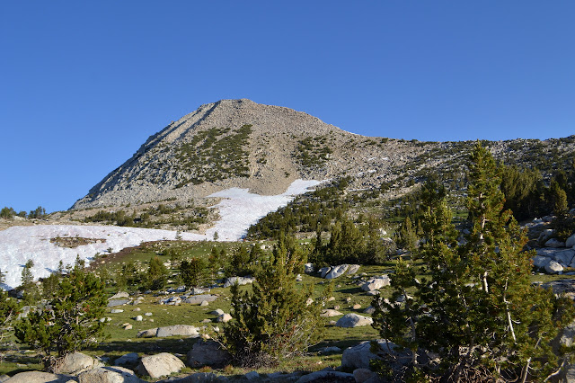
Hutchinson Meadow on the far side is a much more open spot where the surrounding canyon side can be seen. Pilot Knob does not look so high up from here as it rises between the canyons.


Below the meadow, the trees never quite close in again they way they did above. It is much rockier as the canyon narrows. The trail sometimes flirts very near to the creek, which is disconcerting when the water next to it is a deep, fast moving and thunderous mass.


My feet are almost dry from the last crossing when another comes up. People who claim their runners dry out quickly must wear much thinner socks than I do. Mine are wet for hours. The crossings along here tend to come in sets and they get worse as they go along. One has three little logs across just above the trail level. They look like at some point they have been a useful bridge across the water. Today, they are bobbing a little and barely held by their mooring rocks. They also only cross about half the creek. Everything is white water. Still, plenty of stock go through and the shape of the water does suggest there is a smooth walkway down there. Feeling the flow with my sticks before stepping into it, feeling carefully for my footing with each step, and only ever moving one foot or one stick at a time so I can always have a stable tripod, I can get across without feeling endangered. Just the pain from that gash because it is thigh deep a lot of the way.


A creek like this has a tremendous amount of energy and one tends to have some sense of it. Usually, I can just let this sense flow past me, but today it just feels oppressive. Coming to South Fork San Joaquin River will probably not be much of a relief, but I do seem to remember it being on a slightly gentler slope. There are about four groups coming up the last two miles as I head down, in contrast to seeing absolutely no one all day until then. Once on the Pacific Crest Trail, there are always people not too far away. There are two groups at the junction hanging out. I cross the bridge, feeling more anxious about it than I ought to, into the park and start up the gentle trail beside the river. The skies are threatening, but only produce a few drops.

A few of the juniper trees seem particularly familiar as I pass. A bridge to the other side of the river and a bridge back at Goddard Canyon and it is time for some new trail. It starts into the other canyon, but then turns back and starts to climb. I had not paid much attention to the details I would be hiking through, so this comes as a surprise. It gives some very nice views of the canyons. Still, I wonder what it is climbing so vigorously to avoid.


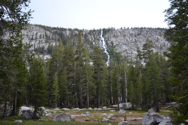
A pair coming down have bug nets on their heads and I realize that the lack of bugs might be a good reason to have stayed below although it does get rather crowded at that junction. There are the low tones of water falling from a great height off to the side. Somewhere there is a waterfall. I can just see white water through the trees. It looks like I might be able to get a much better view although I would expect more trail from those before me if I really can. There is a little to a rock, then nothing really. A buck on the other side of the rock glares at me a moment, then moves up the trail and I go to see what I can see.

The waterfall can be seen. I might have even been able to get a less obstructed view as footing does not look bad to the base of the trees. This would be in shadow in the morning had I stayed the night below. Further up, there are views of the top from the trail, but it is certainly not the same.

There are some camping spots at the top just before hitting the bugs, but they are non-obvious and currently taken. My plan is to get across the ford and then let my shoes have all night to dry out. The trail comes to a crossing, but the sign warns it is dangerous in deep water. Right now it is deep water. It would be at least to my chest if I went for it. The sign directs hikers to use the alternate route and ford it in the meadow. The alternate route has lots of campsites that are available along it, but I want the ford first. It does look a little easier in the meadow. It is more than twice as wide and up to my knee halfway and up to my thigh the rest. It is still a big ford. At least my morning wound has healed a little.


There are no campsites after the ford. One spot looks like a campsite, but then I realize it is the main trail as the alternate route rejoins it. I continue on for more than a mile before finding something suitable just short of the crossing of a big tributary. There are a few spots that look promising before this, but access to water is down a cliff to roaring creek. I need some water and this will not work. The tributary is an easy source, so I finally have my site for the night.
Continue reading day 5 ⇒
©2017 Valerie Norton
Posted 13 August 2017
Liked this? Interesting? Click the three bars at the top left for the menu to read more or subscribe!


Comments