Calcite Mine and halfway to Travelers Peak
Anza-Borrego Desert State Park
Click for map.
I signed up for an overnight backpack way down south and since getting there involves driving halfway to Phoenix (well, 20 miles short of) and then turning right to drive some more, I decided to leave at a time that might not have as much traffic and could give me time to hike at the end. Just a few tens of miles of slow curd around the 405 and one complete freeway stoppage later, I have arrived at the start of a road to an old calcite mine and a good approach to climbing Travelers Peak with an hour and ten minutes to sunset. It is plenty of time to check out the mine, but probably not enough to head up the peak. I had rather hoped this would serve as a shakedown for how my injured foot* is doing and if I can get away with wearing my soft trail runners instead of my immobilizer boots for the overnight. Getting into the scramble up the mountain would be better for that than the road walk to the mine. Of course, maybe I can drive the road.
Heading down to the wash and less than 400 feet down the road, it is clear that had I started down it in the car, I would just be backing right back up it to park beside the sign. There are three guys coming down the road on the other side of the wash. This is odd as there were no other cars parked near me. As I get to the wash, they have climbed into a Jeep with big grippy tires and plenty of clearance that is parked in it. Just one big bump and they give up? Up the other side, there is a little more plateau to walk along toward the mountain.

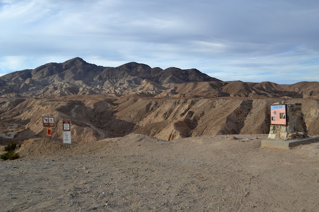
A road heads off to the right with a little sign next to it. Palm Wash. There was a well used track heading off in the bottom of the wash, but it looks like this road is official. I follow past the Calcite Mine sign instead. As it starts to climb, the immediate scenery gets quite interesting.


It seems the hike is a shakedown on me as well. A mild discomfort in my stomach is rapidly turning into a shout of sickness. Or perhaps I am just unable to care for myself properly while focusing on a long drive. I sit down and throw some sugar bombs that call themselves "dried fruit" down my throat and everything seems to calm down. Food seems to be important. I add some nuts to cut the sweet taste still in my mouth, then gobble down a little more sugar coated sugar fruit. Much better. It feels reasonable to continue on, now with more energy available.


The road swings past a few deep dips where the water drains and up to a sign stating "calcite mine area". There is not much to it. The mining technique was quite simple in this soft sedimentary rock. They simply dug out the two layers they were interested in leaving a pair of slots. Turning south, there seem to be a similar pair of slots going through a few more hills. Turning east, there is something I have not seen since the start but have been hoping would come back into view: the Salton Sea. It is starting to glow in the sunset.


The light is almost gone and I have not found the trail to the peak yet. Not for sure, anyway. There is a bit of trail climbing out of the nearby wash and out onto the far ridge with a large cairn marking it that looks suspiciously like it might be a trail to the peak. I just have no idea why it goes out over there instead of on this side. Maybe there is a difficult obstacle to going up on this side. There is a geocache just a short way further. I cannot very well just leave that unfound. I go ahead and give the ridge a try. There does seem to be a faint trail on it, too.

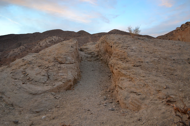
The climb up the ridge leads in short order to the well trod use trail that quite likely goes up to the peak. It is so clear that in spite of everything, I think I might try it after all. Everything includes not just the dark but the fact that at the last minute, I forgot to print out a map of the area. I have no overview of what is going on with this ridge as I start to climb it. One person did say the route was class 2. But the trail, she is so clear!
Just past the geocache, which warns those coming to find it to aim at daylight hours to do so because there are some nearby drop-offs, things tighten up into a nice knife edge. The trail is very clear across this. It gets less so as it climbs steeper in a rocky section. One bit looks like it might be trail around the side. That looks attractive to me because the profile of the peaklets on the next ridge over shows a very steep section on the other side. Unfortunately, this soon shows itself to just be a ridge from the layers, so I climb upward back to the edge of the ridge and up the peaklet. And then repeat on the next one. The top is big and flat and trail seems to travel out to the left, but when I get to the edge, it seems to be an incredibly deep dip to the next climb. I play my light along the depth getting closer to the peak and find the ground does not drop quite so much over there and go to find a new bit of trail. The down even has a couple nice switchbacks, but it is still a big drop. Up ahead there is at least one more of these peaklets and I still have not seen any of the class 2 I was assured was here. Class 2. Just like climbing Arlington in the night. Except without having done it before in the day and without other people who know where to go too and, oh yeah, without a map. Foolish person climbing in the dark without a map, turn back before the mountain gets you! So I do. Although it really did look like a nice enough mountain. You would not get me, would you mountain? But it has already been an hour from the mine and I need to get to sleep at a reasonable hour so my everything will work for climbing tomorrow. Back up to the peaklet with me.

It is another hour to carefully pick my way back down the trail to the mine. It came up a lot further than I thought. I am tempted to follow the trail past the ridge above the mine. I saw it leave the road, or so I think. But I do not know for sure. It is always best to know for sure in the dark, so I drop back to the mine area instead. Travel is much easier from there although there is one spot I thought might try to trick me. I catch it as I start to drop into the wash early on some likely illegal road. Again, I am fairly certain where it will come out, just not certain enough for night. There is a guy setting up to camp as I pass through the last wash and up to the road. It looks like a nice spot where the road noise is blocked.
My foot feels good in spite of the scrambling in soft shoes and the hike has made me giddy for what will come tomorrow. Ocotillo! More cool little canyons! A mountain to climb!
*The injured foot. A little over a month ago on a Wednesday night hike, I stepped downward and onto the side of my foot instead of the more traditional bottom surface of the foot. There was a sharp pain around the middle of the side like I had landed on a small rock with only the protection of a thick layer of fabric. Later investigation found no bruise, but certain motions continued to elicit sharp pains. I could walk around the hard floor barefoot without the slightest bit of pain, but getting off the smooth and flat in my regular trail runners caused more pain. Whatever it was exactly, it seemed to call for a stiff foot bed. I got out what I call the "immobilizer boots": the Salomon 4D GTX that I have worn only rarely for a stomp through the snow or when I was not sure my foot muscles were quite up to the miles in trail runners for the longer hikes. These worked great hiking out to Munson Spring as far as preventing further injury to my foot, but my knees were feeling a deep numbness. The thing about the immobilizer boots is they go quite far above the ankle so all the side-to-side motion the ankle is designed to take on an uneven trail is transferred to the knee instead. I listen to my knees, especially when they whisper. That deep numbness is never a good sign. Knees only bend one way and it is not side-to-side. Feeling a little better and feeling weird about big boots for a little hike, I wore my runners again for a Friday night social hike and finished up with a lot of pain in my foot again. The runners were going to have to stay on the shelf for a while and I would just have to be very careful with my knees. The big boots have been on everything, big or small, since then. Mostly, this has been fine because it is on good trail bed, but when it comes to getting down big steps like those found on Tunnel Trail, I was feeling a bit too immobilized. Usually, I point my toe (among other movements) and take on a lot of the landing in my ankle, but that is not possible in the boots. I felt clumsy and incapable on the more technical spots. Still, by the end of the hike up Mt. Lukens, I actually felt better at the end than the start. Since that hike, there has not even been the whisper of pain from my foot. For the upcoming hike, everything is off trail on uneven surfaces and there could be slight scrambling. The boots will be a liability and I only want to wear them if absolutely necessary.
*photo album*
©2017 Valerie Norton
Posted 21 November 2017
Liked this? Interesting? Click the three bars at the top left for the menu to read more or subscribe!


Comments