Matilija, Upper North Fork trail work
Los Padres National Forest
Click for map.
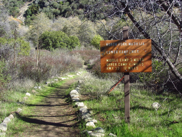
Matilija has been a place that seems to suck in the rain. There have been a few times it has come down 15 or 18 inches in a single night and the creek surged for days, but the canyon took it. After the Thomas Fire, when the rains came heavy, Matilija got at least its share. This time the canyon itself flowed although just a third of the big dumps it had withstood before. We came up it for a day of trail work aiming to get up to Matilija Camp. That is a brief one mile from the trailhead. Since we are working, we got to park at the trailhead instead of behind the gate, which turns out to be at Murietta a little further down the road. The trail is obvious, but there is no evidence of the sign with a map in it. We gather up tools, mostly little saws and trail Smiths and Pulaskis, get a safety talk, and gather into three groups to see what we can accomplish.


We head back to out trailhead. There is no evidence of the little house shaped sign with its map faded to invisibility here either. The fence meant to keep hikers to the easement as they pass through a thin piece of private property is sufficiently intact to show a break for the trail and someone has stacked up a big cairn to help hikers find it. I am in the first group, so work starts here for us. The others head off and then we start in. First thing we find is that the fence is not intact where it crosses the creek and it was pulled across the trail. Our tools did not include wire cutters. One side is buried deep in mud flow and the other goes on to fence we should probably leave. Happily, there is a break in the wire at the first post pulled in next to the trail. Unhappily, it is because the wire is swapping over to barbs. Still, that gets sorted. We trim the dead limbs back as well and go on to the creek. The trail needs to be clear across it.

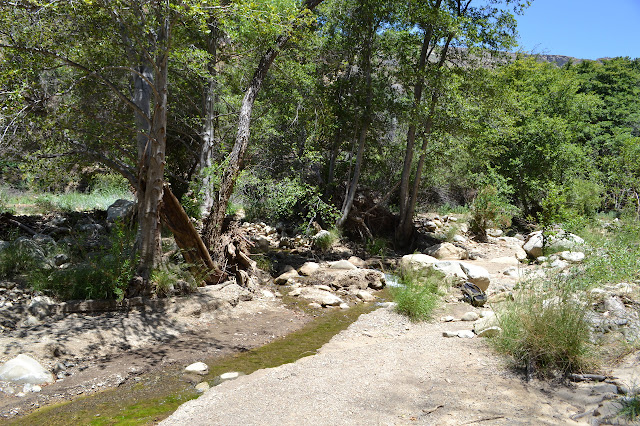
There is a lot of rock lining and branch lining if it is high enough up. We want things to be clear, but not for hikers to feel herded or on a particularly unnatural path. Looking to the ribbons set to guide us, there is a line of large rocks in the creek already that looks like no matter which way it roams or how wide it gets, there will still be rocks to hop across. The creek did used to be wide through here. It requires a jog, but that seems the best crossing. Higher up, we have to move rocks out of the way so there is a comfortable path to walk.

Further on, there are some hints for the trail with more fence, partly washed away, and two more ribbons. On about the third pass by, I even notice the trail sign. One has survived as a very charred post. Three knots along the back even somehow have brown paint on them although most the wood had a really good smolder. The wilderness sign? It is about the right place. Past it is a blank canvas. Someone marked a line with a hiking pole when there was mud here and it looks rather accurate, so we go with that.

Our section drops into a second creek crossing where the trees were. I remember this being a downright shady, dark area thick with trees, now there is a line at the creek. There are a pair of rocks at the crossing. Someone must have put them there, they are the only medium rocks in the scoured creek for as far as I can see up and down.
We clean up the crossing a bit more and then the trail is actually rather there. We have a tree and a snag to clear and then there is a ribbon marking the end of our section and we can just hike to see what else might need doing. The trail is clear for a while, but did have a slide at one point where it now climbs and drops. Everywhere, there is sunlight with some shade instead of shade with some sunlight. Lines of thick grey ash show where there were once fallen trees. The creek seems a few feet lower, but it was 2012 when I was last through here.

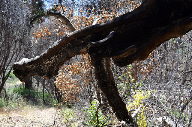
One oak tree with wood exposed in long gashes on every limb and the trunk shows slow burn and a lot of ash down in its wood. It makes me think about how some of these trees can smoulder deep inside for months and even years after a fire. There are a lot of cuts on one branch toward the trail even though that is an old established part. I look along it and finally find the fresh crack where the weakened branch sagged downward.
There is a field of larkspur along one section and they are looking quite nice. There are giant phacelia almost everywhere, since they are a fire follower, but the larkspur was probably common to its spot before. Then I turn a corner and there is some memory that triggers a feeling that there should be a camp around somewhere. I stop and look a bit and notice the second trail below the one I am on. Ah, yes, there was a fair bit of parallel trail where the camp was. I follow it down and back the way I came to a fire ring and flat area. The old secondary camp site still looks good.


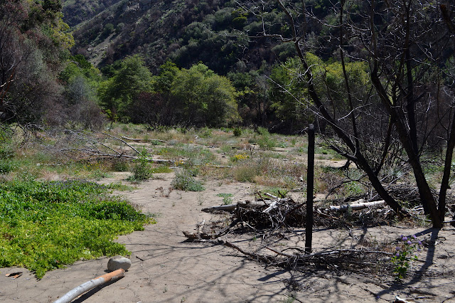
People were talking about digging out the camp. I turn and follow the path the other direction to find out why. Everything turns rocky. This is a spot where the canyon itself flowed. The path is clear down the side just a little way up the trail. It came through the main camp and did whatever the opposite of leveling is. Textured. But more so. Someone found the pipe of one of the stoves sticking up about 8 inches and they really did dig it out. More than two feet down.


There are still trees. The stout oaks are amazing. We are done with the work at this point, so head back down. Since it is National Trails Day, we even get a little extra at the end with grilled burgers and REI sponsored prizes. While we worked, we had a few hikers go by. All that went in came out again before too long, but then we had a small group of backpackers. They did not come out, so must have found something, or at least kept trying longer than we were working.
©2018 Valerie Norton
Posted 5 June 2018
Liked this? Interesting? Click the three bars at the top left for the menu to read more or subscribe!


Comments