Garnet Mountain
Anza-Borrego Desert State Park
Cleveland National Forest
Click for map.
With a few hours of light left in the day, I have plenty of time for the short hike up Garnet Mountain. It is easily accessed from a sliver of land between Cleveland National Forest and Anza-Borrego Desert State Park. There are a couple folks enjoying the view at the end of the road as I start and one more coming up the old road bed that hosts the Pacific Crest Trail looking like he is chugging through a chunk of it. He is quite a picture in plastic slip on sandals, hauling an army duffel with pack straps, and cradling a gallon of water in his arms. He adds to it all a greeting of, "Beautiful country, isn't it?" with so much glee underneath it that there is no mistaking that he is really enjoying being on this trail. But it is, so there you go. I follow behind him a short way.
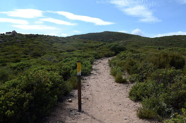
Soon enough, it is clear I should be climbing through the brush rather than wandering along the trail. Both slope and plants are easy enough to travel, so I just wander upward to find the end of a road. I should have just hiked up the gated road next to the trail. There is still 200 feet past the road to get to the peak, but it is even easier than the 250 feet that got me to the road, so that is no bother. That was practically a drive up.

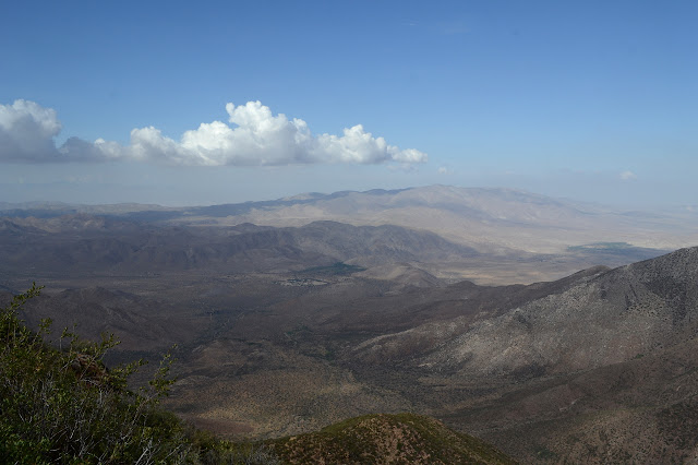
That was far too easy. Good thing I want to go after the benchmark too. I have a coordinate for it, but it seems a rather rounded number, so I am suspicious it is very approximate. I set off cross country for the second high point, which seems a logical location for a benchmark. The brush is generally easy to pass through, but it is possible to make a bad choice and get into something that is thickening scrub oak and difficult to get through. I just drift westward whenever it looks like it might get tough and am soon enough at the second high point. According to the GPS, it is about 3 feet lower, but I am not at the top of the rocks. They are the same height within the margin of error.


There is no benchmark apparent. If I had printed out the pertinent scrap of map or just taken one more simple note, I would have remembered that the benchmark is actually out on some random rock and it is not even one along the ridge as would be expected. I just have the point and the point says it is a bit further on and there are some nice looking rock outcrops further along, so I just wander on over to them. This does require passing through a thin line of scrub oak, but it is not so bad.

I poke around two more rock outcrops and then take note that I have now overshot the point in the GPS a bit. It looks very unlikely, but there is one more rock over there. The scrub oak, on the other hand, is less than inviting. I follow one line with deer leavings, but even that one does not go anywhere I can push through. I turn my attention to getting down to the PCT again, instead. It looks like it will be a challenge, but there is a path that only requires a short bit of getting downhill through scrub oak, provided I have guessed correctly where the trail is. I can see it coming closer, but not below me. Anyway, downhill is generally easier than uphill. Gravity is on my side and the bushes tend to grow a little downward. After a little winding and one last push of maybe 20 feet, I am indeed on easy street.

The PCT really is easy street to get back. Hardly any climb and quite a lot of wiggling bring me back to the road. There is still plenty of light and there is a perfectly good use trail heading up the peak south of the road, so I go for that one too. The climb seems to keep having just a bit more climb as I go. After a shallow dip, it gets even worse. The top is here! But it is not the top over and over.

When I do get to the top, I push over the top and a little way down the other side just to make sure. There actually seems to be a better trail coming up that way. Not by much, but it looks attractive. I think it looks like it is going for something steep, too, and decide I will go back the way I know. It is not so bad either.


Once down again, I go for one last poke about along the PCT in the other direction. This is a curious spot because people have filled up the rocks at the edge with memorials. Some are quite elaborate and have collected many names over the years. Whatever the story, it has been growing for a long time.

And then it is time to go find somewhere to camp and definitely time to eat.
©2018 Valerie Norton
Posted 28 July 2018
Liked this? Interesting? Click the three bars at the top left for the menu to read more or subscribe!


Comments