Monument Peak
Cleveland National Forest
Click for map.
After being in San Diego for unrelated nefarious reasons that only slightly involved being a bit of a jungle gym for an enthusiastic child aged 1 year and 2 days, I headed out to the Laguna Mountain Recreation area to go after three peaks listed on the Hundred Peaks Section peak list, each very near a segment of the Pacific Crest Trail. My first target is Monument Peak. It has a few named peaks nearby and someone has marked a few of the minor bumps that just happen to have a poorly surveyed elevation on PeakBagger. Except for Stephenson Peak, they are all near to the trail and look easy enough to get to. Signage on the road is lacking, but my first guess at the right bit of parking contains interpretive signs referring to Storm Canyon, a boardwalk overlook, and steps down to connect to a well established (but unmarked) trail winding its way through the area. This is probably the right spot.

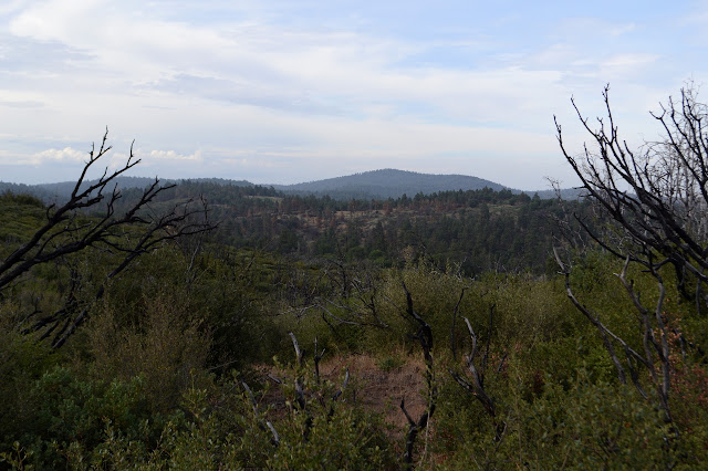
The day should be a bit cooler than it has been thanks to the remnants of something tropical moving through the area. It comes with some drawbacks. In the time it takes for a quick run back 0.2 miles to the car too actually lock it, the canyon fills with cloud taking away all views. The trail climbs up as it gets out of the canyon and I seem to get out of it as I continue. More chunks of cloud envelope me as I go, alternating views on the right of dying trees up on Laguna Mountain and views on the left dropping far down to the Anza Borrego Desert with white outs of 100 foot visibility.


The first bump along the way, at least according to my GPS, is about 5 feet off the trail and occupies the edge of a ridge where there is a gentle upward slope leading somewhere else. This is even supposed to be one of the named spots. I dutifully tag it, although I am mostly looking for any reason to perceive it as a peak. I tag a higher point that can be gotten to without ever going downward from the marked spot, too. It is also about 5 feet off the trail, so no challenge.

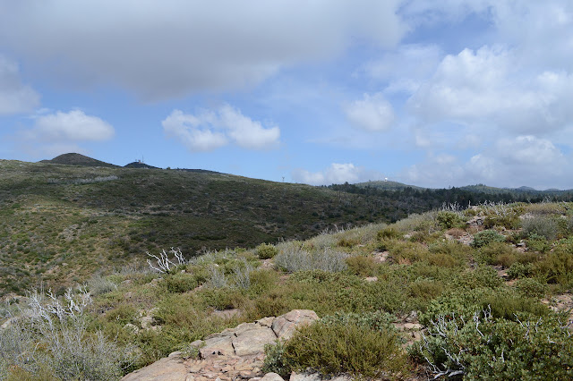
Up a rise to my left, there seems to be some sort of monument or something man made of rocks. There is a perfectly good trail up to it, so I follow along to find a pedestal of rock topped with metal marked with the local peaks that rise from the desert floor. Visibility is not that good even when the clouds are not passing and I can only see about half of what is marked. A few names are familiar from climbs. Most are things I have seen on the peak list. It is fun to try to spot things out there, even if the Salton Sea is just a generally brighter spot in the distance.

The clouds take the last of my view again and I follow a slightly better established trail back out to the PCT. This one is marked with a sign for "Foster Point" meaning this is where I was trying to get to in the first place, not that random spot along the ridge line. And if you cannot trust a PeakBagger coordinate... well, you are supposed to email and get it corrected. The proper destination is certainly more interesting.

The next peak along is a minor bump with provisional status on PeakBagger and a few tenths off trail. The Cedar Fire has left it easy cross country to get to it. Maybe it was before, too. Not much of a climb and not much of a peak, but there is a glass bottle for a register at the top, which is about 150 feet off from the point on PeakBagger. This is just an example of the "dirty" nature of the data and not an outright error. It is very much sufficient to get one to the top.

Back on the trail, it is not too far to a possible jump off point to go up Hays Peak. Trails lead up to the north end of it and the area is riddled with camp sites established by the great hoards that start this trail from the south end each year. A pair of fellows I first bumped into as I left Foster Point are enjoying the view, while there is one, from a rock. They are disturbingly enthusiastic that I am able to hike all by myself. I have no idea how to take this as this seems like a particularly easy hike. They manage to avoid implying that it is somehow harder to hike on my own because I am a woman, so a point for being smarter than average. They continue on to Monument via the trail while I try out a thin path up the side of Hays. At first, it comes to more tiny camp sites, and I worry that is all it will do, but it keeps on going and settles into something just clear enough to follow without much difficulty right to the top.


The fellows said there was a wide track down the other side, but it is quite similar to the thin track I followed up. It thins and braids a little just below the top, but settles out again and joins a wide fuel break. This would be a wide track, except it is growing in a bit. Lower down, the Monument Peak Trail joins the fuel break as well. Monument Peak is the high point for at least a few miles, so this is a well established trail. After passing by a fenced area, it gets rather steep and clambers over a few rocks before reaching the top beside some microwave repeaters and various other things. The road offers an easier route for those who do not want to go quite so directly up.


The trail past the rocks gets a little closer to the structures than the city is probably comfortable with, but peakbaggers honestly have no interest in structures except as they block access or the view. The highest rock has been kindly left for folks to play on.


The last peak planned for the day is Stephenson. It is a longer route out to it, accessed by a paved road, well fenced, and sounds like grumpy people visit it from time to time, so I was ready to just let it go, but I still have plenty of time and may as well grab one more bump. I follow the paved road down off Monument and across, but grab an old dirt road that looks to be following the ridge toward the end.


There is not much more for me to see up on Stephenson Peak today. The clouds were thick enough to toss off a couple rain drops. I take the dirt road back down, then try a gated dirt road that continues down to access the PCT below. It would work, but I want to access it where it is higher up and try a faint side road that goes nowhere in particular but lands me a few feet below the paved road again. Oh well. On the way, I thought that a road down to some power lines looked like the best access to the trail so I try that instead. This works well, except they seem rather low for any sort of power lines in a public area and happen to be marked "high voltage". The road stops at the second pole, but I am not the first one to follow this route down and a faint trail takes me the rest of the way under the disconcertingly close power lines.

Just down the trail is a fellow popping out of a rather elaborate hammock with pole supported shelter looking every bit like he is backpacking through here. I can think of no other reason except that desire to hike every foot of this long trail. Perhaps I am showing my ignorance of the area. It seems entirely the wrong season for the area. The last few days were scorching and it will be again in another few days.


The PCT offers a very easy hike back, twisting the long way everywhere and never climbing or dropping at any great slope. The day warms and clears a bit, but not all the way to unpleasant.


©2018 Valerie Norton
Posted 27 July 2018
Liked this? Interesting? Click the three bars at the top left for the menu to read more or subscribe!


Comments