Agents of Discovery at Trinidad Head
California Coastal National Monument

Did you know the Bureau of Land Management also does Junior Ranger programs? In the case of the Trinidad Head Lighthouse, there is both a traditional paper program (called Junior Explorer, but it's the same thing) and an electronic one using the Agents of Discovery app. I've been meaning to try out the paper one except that it seems like a lot of paper (waste!) and it's not as approachable as a PDF on a tiny screen. (Plus it's very hard to take a rubbing on a PDF.) You should be able to pick up the booklet at either the Arcata Field Office or the Trinidad Museum. The electronic one is made for that sort of small screen, so I decided to try it. I was sort of expecting a rehash of the Redwood Edventures Quest for Trinidad, but that's not what I got.
So step one: download the app. It is huge. The app is taking 166 MB and it has another 482 MB of data after downloading 1 mission. There's also 1 demo and 5 other missions that can be done from anywhere listed as downloaded, but still showing the download arrow. It wants quite a lot of permissions including all sorts of bluetooth stuff that just looks like hacking vectors to me. It takes a couple minutes to load and you have to agree to the EULA every single time. It takes a rather long time to load the mission, too. Once I got the mission downloaded and open, there's no information on how to start although there is a welcome. Sitting at home, "tap to continue" and it just says "out of bounds". Click on the "i" with a circle and it explains markings on the primitive map. Eventually I figured out to tap on the seal, which has an "About The Mission" button which gives directions on where to begin. So then I finally know to go to the dirt lot for the Trinidad Head Trail and other public spaces nearby. Let's just say my initial impression wasn't good.

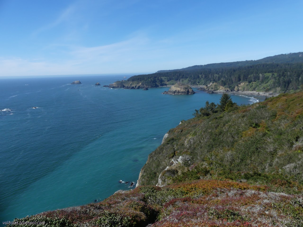
Incidentally, there are much easier places to visit the California Coastal National Monument nearby. Both the Waluplh-Lighthouse Ranch and Lost Coast Headlands are generally open for visits and small hikes. (You can find them in this list of my visits to the monument.) Here, the only generally accessible location in the monument is the viewing platform near the cross. Everywhere else is still Coast Guard land and not actually part of the monument. You can only really visit it here every first Saturday for 2 hours. However, the offshore rocks and islands that make up the majority of the monument are on better display here. (Landing is not permitted on them, so there is no visiting that unit of the monument.)

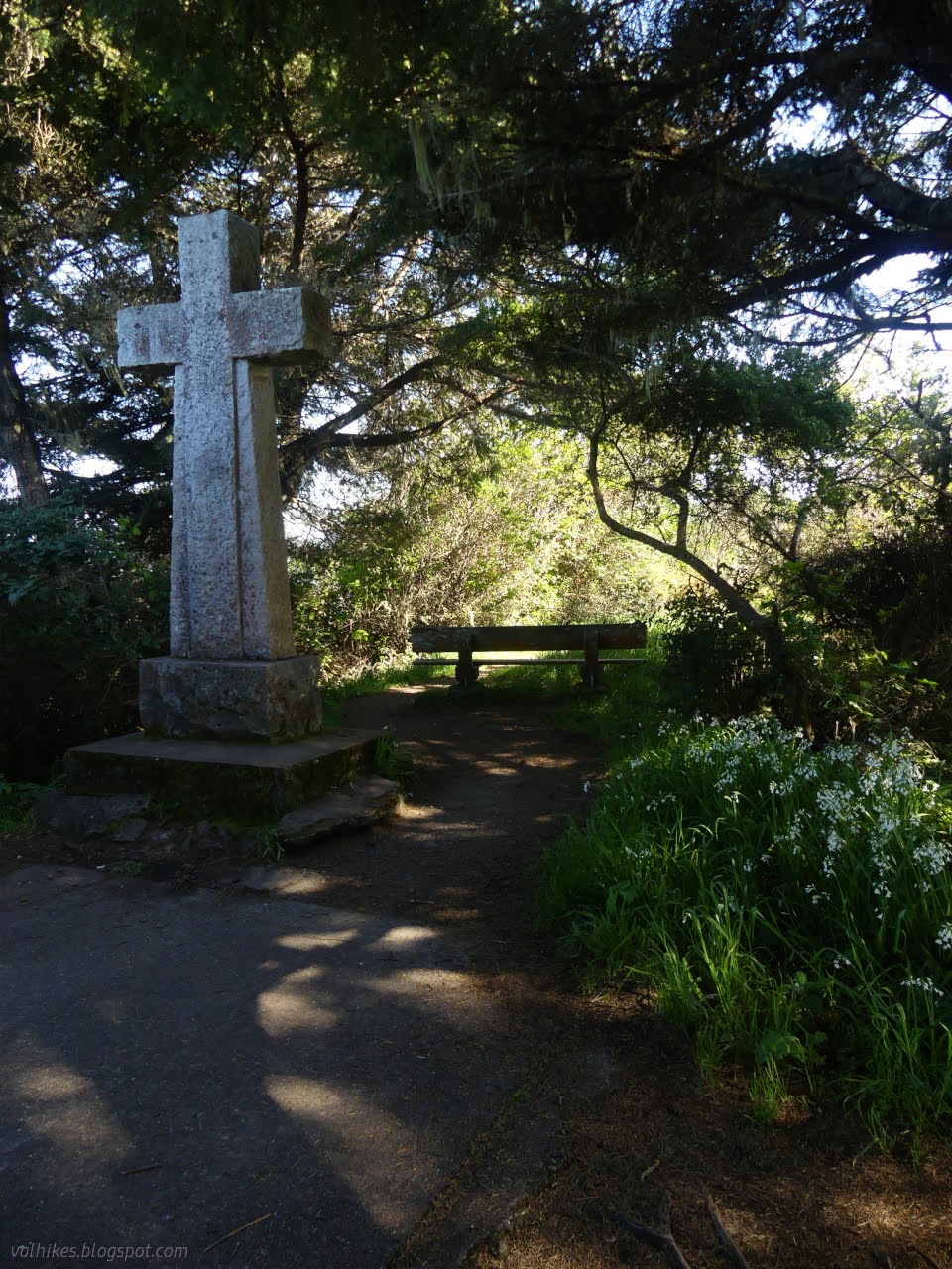
Once I'm in the parking lot and "in bounds", I have markers for the various stops, but still no instructions for getting to them. They are set against areal photography of the area, but no actual map of the trail system you'll need to hike. I found myself comparing it negatively to the Quest, which was very clear about what level of activity you will be embarking on to complete the thing. The first is easy enough at the side of the lot. Get to the Memorial Lighthouse and it activates the activity associated with it.


And then where? Follow the road to the junction ahead where the trail splits off to make a loop and stop there.


And here at the overlook is another stop. It has a question asking for knowledge, but no background to gain that knowledge. It's multiple choice, so just go for something based on what makes sense. I guess that's a way to learn? There's no further instruction, so off you go hoping to get close to the next dot by walking the path. Will it involve the spur? How far is it? I found myself looking a bit much at the handheld rather than engaging in the environment and thus found another negative for it in comparison with the Quest, which is done in a way that increases one's engagement with the environment since you have to watch for the elements that mark the next stop.


I tried the spur to get closer to the point on the app, but never got there. I didn't have to get that close to access the question. What are whales doing at various times of the year? Well, they eat in the north and have babies in the south and presumably that north part happens in the summer. Maybe there's a sign near the point to help? I tried again to get closer to it, but even at the high overlook spur, I wasn't there. Admittedly, just apply a little logic and they all work out.

Based on the areal photographs "map", I figured out the location they're encouraging people to try to get to is actually a very low flat off the other side of the viewpoint. There may actually be a scrambling and crawling use trail through the thick brush to get out there, but you are strongly discouraged from leaving the designated paths. It seems unnecessarily sloppy to me.


Trail actually climbs higher than the high viewpoint as it continues around Trinidad Head.


I was just about to run out of trail and just have road left. I headed up to the top, then doubled back to see what one can see from the lighthouse viewing platform this year. Once again, Trinidad Head would be my first peak of the year. Well, not counting the mighty Mount Trashmore. It would be sadder if I hadn't had so many nice peaks at the end of last year.

At some point, the Agents of Discovery app had fallen out of memory. This meant another couple minutes to get it started again and half more to get the mission loaded. I see this as a weakness of the Android operating system, though suspect developers can do something to reduce it happening. My progress was gone. It says you have to register to get prizes, not just to remember you've answered half the questions. I tried registering, but it refused to use any mobile data, not that that was the error it claimed. That's a weakness of the program. I was able to reanswer most the questions at the peak. I have no opinion if this is a good or bad thing.


So I headed down the rest of the trail, now become gravel access road to the instruments at the top, then paved access road to the real lighthouse.


They've updated the sign on the gate to the real lighthouse to the current open hours. That's 10AM-noon on the first Saturday of the month, in case of interest. It used to say until 2PM encouraging people to arrive too late and have to wait another month.


I finished off the hike redoing the first question, the one I couldn't do from the peak. "Great work, Agent! You've earned the Coastal Hero Snapcode, have fun!" it says. I still don't know what wonderful prizes I get if I make an account. (They'll fill in and stamp the certificate on the back of the booklet if you do the paper version. Also do the ones for the Headwaters Forest Reserve and the King Range National Conservation Area and get a poster, badge, or patch.) I did make an account when I got on some wifi, but it has lost my progress again. It does remember I've visited once. Oh, wait, no it doesn't. It just increments the "visit" count every time you open the mission, and that only if you're logged in. Having an account has also gotten rid of the need to agree to terms every time one opens the app.
Perhaps my experience would have been better if I had run the demo at home rather than going for the close-at-hand real thing. There can be some learning out of this app, but it requires a lot of patience for a resource hog. It has different content from the other options (the Junior Explorer booklet or Redwood EdVenture Quest, both linked at the start). I see the Junior Explorer booklet wants me to visit the Trinidad Museum and its gardens. I really ought to do that some time. It is open Thursday-Sunday 12:30PM-4PM. And they want me to visit the Marine Lab. Wait, you can visit the Marine Lab?
*photo album*
©2024 Valerie Norton
Written 30 Apr 2024
Liked this? Interesting? Click the three bars at the top left for the menu to read more or subscribe!


Comments