Grasshopper: Grasshopper Trail, River Trail, and Bull Creek Trail South
Humboldt Redwoods State Park

DAY 1 | DAY 2 | DAY 3
I was slow to get up, hoping the dribbling would let up even though the weather seemed very settled on dribbling. The night's point prediction was 13% chance of rain falling quickly to 7% and continuing down to 3%. None of that discouraged it from dribbling the whole night and into the morning. The bear box hadn't proved to be watertight and everything near the front had gotten wet at the bottom and drawn water to everything behind it. Admittedly, that was of minimal imporance for everything except for the park brochure and map. It would never be the same.

I put away the bedding and cooked breakfast under the tarp. By the time I got everything in my pack, then the wet tarp stuffed in the pocket, there hadn't been much improvement. I pulled out the poncho to keep the drops off. I still didn't know if it was rain or the trees drawing down the fog. The redwoods are very known for drawing down the fog, but I was under Douglas fir. They definitely do at least a little of it. The day's plan was simple: take Grasshopper Trail to River Trail to Bull Creek Trail South. I could make it a little shorter by taking the north trail, but it hugs and even joins with the road some. South is better. This is nearly all hiker only trail, downhill, and under big chunks of old growth. Are you ready, knees?

The Canoe Fire burned the south side of the trail and some north side in 2003, but it is the later Grasshopper Fire in 2017 and the Grasshopper Fire in 2019 that provided most of the fire scar I saw during this trip. What I could see of the upper forest around North Fork Canoe Creek looks to have had a bad time.
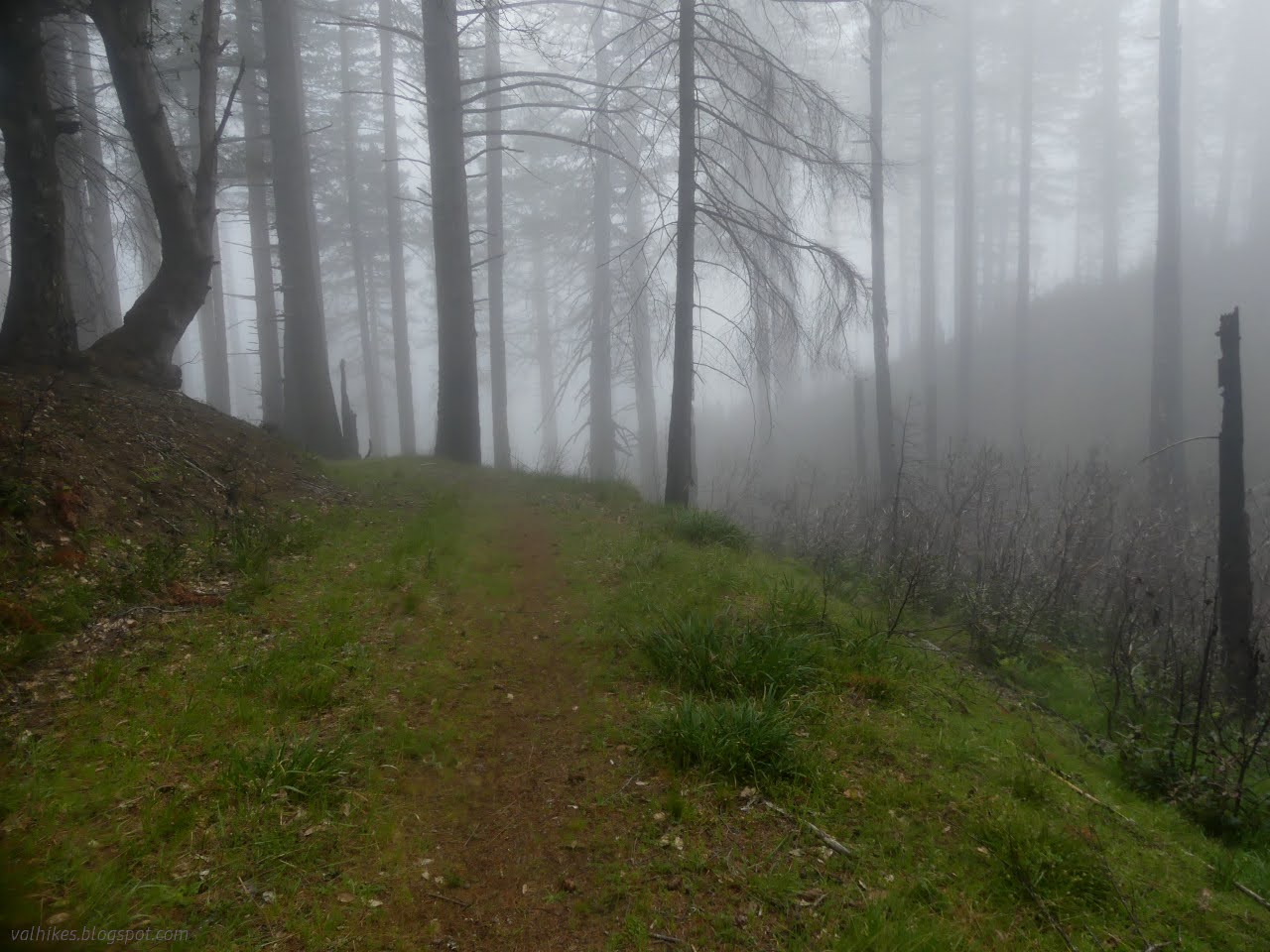
The poncho wasn't doing much and as I descended from the clouds, it had even less to do. I kept it on only because it was slightly warmer than not. It had started a bit colder than the day before.


I found a pretty big tree down on the road. There had been clearing up until that point, and it was appreciated, but only the branches had been cleared from this one. It did make it a whole lot easier to cross, but there was no more maintenance after. I was reminded that there can be some real show stoppers on the River Trail. Trees with girth unclimbable for 300 feet can come down over the winter.


I hit a junction with another road that is not marked on the map, but the signs were pretty clear I wasn't to go along it. Maybe I wasn't to go along the removed old road either. I was passing through a logged area and the road changed character at that point, becoming straighter and steeper. There's probably some plan to reroute at least the lower part of the trail when the time, money, and personnel stars all align. For now, direct it is.


I was over halfway down the hill when I found the one single little flow of water by the trail. Otherwise, the route down is completely dry.


Almost at the bottom, the trail splits for easier access heading north or south. I took the turn for "Canoe Creek Loop Trail", which no longer exists. This is the south connector, but I was looking to get more time under the trees beside the river. It adds about a mile to the route to go this way.

It's a continuation of the steep and direct old road and as it finds the trail, there's a blocked path that continues. I believe this was the other part of the loop that made the Canoe Creek Loop. Before that, it was the old road I've been following as it makes its way to a ford in the river. While this bit is still obvious, the lower portions are undoubtedly removed by nature. I turned left to head downstream.


They probably aren't the best trees along the trail, but that's no reason to dis them by missing them to save a mile. Then again, I passed the junction for the other side of Grasshopper Trail and there was still a long way to go to Rockefeller Grove and even longer to Big Trees.


I passed the junction with the trail to Burlington. One could make the hike and bike sites at the campground across the river a stop along a backpacking trip, but it would be a more pleasant option in the summer when the bridge is up rather than now when the ford is dangerous. And still 3.5 miles to Rockefeller Grove.


I encountered a potential showstopper. A tree I couldn't see over rested across the trail among a jumble of broken limbs, many not its own. I wasn't going to worry until I got close enough for a good look. That showed a line of discolored dying foliage where other hikers had already been. It took some care across that shattered wood, but getting to the other side was quite straightforward.


I passed the first trail that connects over to the Rockefeller Loop Trail thinking it must be 3-3.5 miles to Big Trees now. I passed the second getting told it was 4 miles. Those are short miles, right? There was still the Bull Creek Trail North option and there's even a tree to try crossing the creek on from the other connector. I didn't go for it. Four more miles. Oh, and then a slight double back.

At first, Bull Creek Trail South travels high up above the flood plain of the big creek. There was another big log down across the trail, but again a little looking around found stomped and discolored broken and dying foliage to show the way and a little care made it happen.


It eventually comes down. I thought about cutting across to the north trail where they both get quite close to Bull Creek. It's a bit of a cliff on the south side and the scrambling trails go to the swimming hole, which makes a bit of a deep crossing. The trees are beautiful, but I was getting a bit too tired to like it much.

Once near Big Trees, the trail gets to twisting back and forth, taking three times as long to get anywhere as it might have. It's to disrupt the sight lines to make the busy areas seem a bit less crowded. There wasn't much need today, although I could hear someone out there somewhere.


Johnson Camp Trail comes down just before Big Trees. I found it was closed, which seems like the sort of thing that should have been mentioned as I registered for camp sites. It's a pretty common one to hike. I didn't see alerts when I checked the web either, although state parks have been pretty good at having those before.


I did take the short way through Big Trees. The sign to tell me just how big Giant Tree is had been pulverized by a smaller oversized tree. The damaged observation platform was closed. It's not as big as all that without some scale!

Big Trees also has a log that people use as an at-your-own-risk bridge. I decided to go for it. The way up wasn't hard and the fibrous bark is still offering some traction (offer not available in icy conditions) but the root "ladder" on the far side was smoothed to frictionless by the many hands before.

I found the section of the north trail I needed on the far side of the parking lot to make my tired way among more amazing trees back to the car. The sun finally came out.


There's a short connector from the trail to my parking area where I was happy to find an unmolested vehicle.
*If you want to see what the temperature during this trip was like in detail, that's part of this equipment post* *the photo album*
©2024 Valerie Norton
Written 9 May 2024
Liked this? Interesting? Click the three bars at the top left for the menu to read more or subscribe!


Comments