Posts

Hammond Trail

Image
McKinleyville Parks and rights of way McKinleyville Land Trust ( map link ) All the rain that came through has brought the Mad River to a level not seen at any time last year. Admittedly, it stopped and the water has dropped back down a bit. That has allowed the little creeks started to run clear again. It's prettier when it all runs clear. I decided to go out and visit the river in its long run from getting almost to the coast (near the old railroad bridge) to actually breaking through to the ocean waves over 3 miles to the north. This time I would use the more common path on the McKinleyville side of the river rather than the long sandbar . There's a lot more places one might start such a trip and I've marked all the spots with public parking along the route. I actually started at the aforementioned bridge, the southern terminus of the Hammond Trail. Feeling a kind of tunnel vision at the southern terminus of Hammond Trail. The Mad River is still muddy on its...

Ryan Creek

Image
McKay Community Forest ( map link ) I was battling the "but I've already been"s when I visited the newly opened section of McKay . The north end is well used, but not expected to open until the coming summer. (The previous section was aiming at the summer, too, but got the fall.) It's hard to just leave it when seeing so many people enjoying the area. I broke down and went for a look. The main entry into the north end of McKay Community Forest should probably be locked I wandered in under the trees along the road, then nearly immediately turned off onto a well used trail heading east of the road. I was struck by how much more open the forest is in this area. It doesn't hurt that the day was nice and sunny without having to wait for it. Trail among the trees leaving and ferns that haven't been stomped A small stream comes down the hill

Bob Hill Gulch loop

Image
McKay Community Forest ( map link ) As of September 29, 2022, a portion of the McKay Community Forest is finally open. This includes the Northridge parking area in the southern portion of the forest and about four miles of trails. A map can be found here . I decided to return to the forest ( prior hike from this start is here ) to hike the longest loop available on the now officially opened trails. The parking lot was indeed open with a great big sign stating the gates would get locked at 6PM. Gates locking at a variable time sometime after sunset seems pretty common for Humboldt County parks. Kiosk with map and other trail signs at the trailhead beside the Northridge parking area I turned onto the Bob Hill Gulch Trail, which is a much smaller trail and harder to see than the Perimeter Trail, an old road that is also an option. Bob Hill Gulch turns back on itself and really is just a longer way through the dark and scruffy forest to join another old road that branches from t...

Megwil and Omenoku Points

Image
Trinidad State Beach ( map link ) After wandering a few beaches (and rocks) south of Trinidad, I headed off to wander a few rocks (and beach) north of Trinidad. I found the parking lot at the north end of Trinidad State Beach working its way toward full. Most were headed out toward Elk Head, but quite a few got caught by the trail down to the beach around College Cove. There's plenty of beach down around College Cove, but the arch is watery I shuffled off fairly directly to Megwil Point on Elk Head. Lots of cliffs to the north Out to the point to look south to Trinidad Head

Trinidad Beaches

Image
Trinidad Coastal Land Trust ( map link ) I finally got the roughly 2.5 months backlog of hikes down to something reasonable, and after just a bit over 2 months of solid writing. (Yes, it takes me as long to write up a hike as it did to hike it.) Between all that writing and a general feeling of saturation of the local area, I wasted a lot of lovely November days not going anywhere interesting and got into a December when it was harder to find a halfway nice day. I decided to use this particular window of good weather to go out and see what the big tides were doing in Trinidad. The king tide already passed, but the high would still be over 8 feet. So, while the rest of the country was popping their pipes in an extended freeze, I went off for a day at the beach. The temperature was pleasant, the wind drifting about when it did anything at all, and the fog probably wouldn't cooperate. It's been around and Trinidad is good at gathering it. Houda Point I started off at Hou...

equipment list

Image
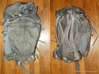
Back in July, I mentioned I took off backpacking into the West Elk Wilderness with a 36 pound pack . Since I had about 10-11 pounds of food and water, that left about 25 pounds of gear, which seemed like a lot. Really, it shouldn't be too hard to be at a 20 pound base weight and much smaller weights are not too outrageous. I didn't have time to analyze it then, but I do have time now. So, here is a gear list which will show where it is and where it could be. Weights in bold were in the pack. So, what's in the pack and why does it weight that much? What could it weight and leave me still happy to be out hiking? Big 3/4 backpack The pack is a Gregory Jade 63 from when Gregory decided they were going to reduce the weight of their packs a lot. I've got a 50L pack from just before they cut the weight which comes in over 4 pounds and carries a lot more weight more comfortably. This one is fairly straight and tends to slip down. However, it does come in at 1650g...

Arcata Ridge Trail

Image
Arcata Community Forest ( map link ) I got back to Arcata just in time to participate in a volunteer work day on the long awaited last segment of the Arcata Ridge Trail. It was a little closer to finished than the work solicitation email seemed to imply. In fact, there was a city worker along for this one who had placed a couple signs in the ground before we got there and the trail was officially open! It's also a little steeper than originally designed and a bunch of crushed rock got vibrated into place at the bottom to try to mitigate the worst of it on that work day. I came back a couple days later to finally, truly, hike it end to end. Not like that last time . There's still projects waiting to happen, like replacing these narrow steep steps that are meant to give a worker access to a water tank and have been pressed into service as main entry to the Sunny Brae part of the Arcata Community Forest So up the steps and past the signs with maps and rules and even a b...

Gray Falls

Image
Six Rivers National Forest ( map link ) It was a geocache that brought this spot to my attention. I didn't find it or anything, but sometimes there's more important things to a geocache than being there. Well, for me who is a hiker who geocaches rather than a geocacher who hikes, anyway. (I might be part of a very small minority.) There's also a Redwood EdVentures Quest to bring people here. I didn't have signal or the PDF nor are there any brochures provided, so couldn't do it. The map on it would have been nice since neither the Forest Service topos nor OpenStreetMap had any information on the trails. (Another on my list of things that need editing on OSM. At least that's one that can be fixed.) There's signs out on CA-299 for Gray Falls to help find this spot. Take the right fork on gravel too narrow for any attempt at passing 0.5 miles to the picnic area with tables and a toilet and a small trail system. Kiosk under the tall trees at the picni...