Coastal Trail Tey-wo-lew section
Redwood National Park
Click for map.
The California Coastal Trail is a long trail in the making. Unlike the "Pacific Crest", it goes through areas where people crowd in, so it might forever be in the making. It also has an awful lot of road hiking, but maybe less so in the north. This part is a mostly abandoned piece of the Coastal Drive that is about 3 miles from gate to gate. It seems likely to be a lovely bluff top excursion through the trees above the roaring surf. Also quite easy.

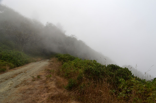
It is foggy and it is paved, although the paving is inconsistent. It does look like someone gets to use this road. Coming to a turnout, it is clear that this road was built for public use. On the left edge, there is an interpretive sign. The surface has nearly become a uniform yellow from age, but it can still be read. I stop for a moment to learn about the beach below and how gold has been found on it and various attempts to collect it on an industrial scale were made but never paid off. Jeff will come by a little later and read it too and be appalled by the thought of anyone using mercury so close to the ocean. Stand beside the ocean and it will tell you that it is infinite and powerful. All that goes into it is lost forever unless the ocean itself chooses to give it back. Of course, this is bluster, but humans used to believe it.


The turnout is clearly meant as a lookout as well. Surely the beach it refers to is stretched out below. As I look out, the cliffs simply vanish into the fog maybe as much as halfway down. I can hear the surf below crashing against rocks and cliff, but there is not even the slightest visual clue of its reality.

So I have to pay attention to the things closer at hand although I can often hear the surf below. There is a little more visibility along the road.


Then I spot the banana slugs. And more banana slugs. Actually, they are quite hard to miss. They are in the road and on the leaves on the side and there may be more than I have ever seen before in a single area. Oh, and they appear to think there are not enough so they are making more banana slugs.


The banana slugs thin out and vanish as the vegetation changes and I have another chance to see nothing below. The churn of the surf still assures me that there is a below and it contains the ocean.


The road turns slightly away from the bluff edge and hits a gate meant only to block vehicles. A thin trail continues along the bluff, but I am not certain if it is official. My map does not indicate there is any intersection to worry about along this trail. A sign to the side of the gate does not actually forbid entry, but it does identify the land as state prison property and warns that all who enter may be subject to search. I think I will take the thin trail instead. Upon greater reflection, the thick growth around it does seem to be coming from a wide, flat area as though this, too, is old road bed. Its abandonment is simply more complete than the previous section.


Nature pushes in just a little bit further along this section. There are even more banana slugs along the way, some trying to get stepped on.


Gradually the road looks less abandoned. There is a small turnout with a thin trail heading out onto the bluff from it. This looks too well used to ignore, so I start down it. It pops over a little rise becoming enveloped in the green and starts down with enthusiasm. I would really like to go down it as it seems to be heading for the beach just north of Split Rock, but I also had a time to finish which leaves no time for casual excursions down more than 400 feet of bluff.

There is a road above me and then a gate. End of the line. I asked to be picked up at the High Bluff Overlook, so I have a little bit of road walking to finish up. It is all very much downhill, then the coastal drive continues (one way going north) to the right and there is a big parking lot with bathrooms and picnic tables a little further down to the left. I have to go out past the picnic tables to see if maybe I might finally find a bit of ocean.


After finally confirming that there is an ocean, I watch it for a bit, then wander over to the actual overlook which goes off a trail out the north end of the parking lot. This drops down a little more to an area that appears to have been flattened out at some point. The sign by the lot indicates there is beach access, but the only marking for it is another sign saying it is closed and dangerous. But there really is a beach to look out over.

Then it is time to head off for new adventures.
©2017 Valerie Norton
Posted 9 September 2017
Liked this? Interesting? Click the three bars at the top left for the menu to read more or subscribe!
Comments