North to South: Desolation Lake and Pilot Knob
Sierra National Forest
Click for map.
DAY 1 | DAY 2 | DAY 3 | DAY 4 | DAY 5 | DAY 6 | DAY 7
Another poor sleep, but that is what it is. Today is a day to grab a peak. First up is getting back down to the main trail. Packed up, I follow the trail I found beside my camp back to the snow field and then make my way downward toward where I know the rest of the trail is. Staying on trail does not last long. As it climbs, I head down, aiming at the outlet of Summit Lake. These lakes often have a rather rocky outlet that can allow for an easy crossing. There is more snow, and then the slushy area of melt water below, to navigate to get there.

I can see the trail just up from some rocks on the other side, so it is not far to go to get there once on the correct side of Piute Creek. The outlet is as expected, full of rocks. A little plotting, and I am across with a few easy bounds. On the other side, I seem to already be on trail below the rocks. Well, that was even easier than expected. There is a tent way up the side of the valley still as I make my way down.

The trail seems a bit faded in spots and then continues on to a lake crossing. The crossing is not very good, there is one spot where everything is deep. A cairn signals to head over to another spot that is generally deeper, but never too deep. I am looking for another unmarked trail and the fact that it looks to me like I should be a lot closer to the now vanished tent up on the side rather than down by the creek makes me drop the coordinates shown on the Trails Illustrated map into my GPS. It indicates the junction is just a couple hundred feet away further along the creek. That seems rather contradictory since the trail should be higher. Whatever, there is a faint "Y" in the grass and I turn onto the lesser rather than continue toward another bit of lake crossing.
The track I am on is faint, but continuous and easy to follow and dry. In a couple of minutes, it hits another trail, this one better used and with a lot more footprints on it than what I left. I guess I should have climbed up those rocks after all. My faint track crosses it and continues to climb. Since it may be the trail, I continue on it. In short order, there is a second trail full of footprints that might be even better used than the last. How many versions of the Piute Trail are needed through here? My trail still continues upward, but seems to grow a little and is marked by a pair of wide, low cairns to either side, and now even have footprints itself. These make me a bit more confident that this is the trail to Desolation Lake.

The trail makes a particularly easy climb toward more of the Humphreys Basin lakes. Small ponds pass by between the named lakes.


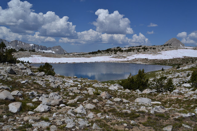
There is a little bit of creek to cross along the way, but nothing difficult. Some of it does mean wet feet again. There does seem to be quite a bit of water moving through Lower Desolation Lake. The inlet at the northwest tumbles greatly as it goes. This is a little worry as I am aiming at crossing the outlet of Desolation Lake on my way to Pilot Knob.


Desolation Lake is, as expected, a massive thing. I leave the trail to start working toward Pilot Knob, a structure that dominates the confluence of Piute and French Canyons. I must not be being careful or observant enough as I go, because rounding a rock leads to a furious flutter of wings as a red tailed hawk takes for the sky. Making my way for the outlet, it is rocky, but not like at Summit Lake. I have to slog through half of it to get to rocks to hop the rest of the way. My impression from below is correct, there really is a lot of water moving through these lakes.

Soggy feet does not end with crossing the outflow. There is a snow pack on this side and it is melting into a boggy area below. I maneuver for not too much climbing in the snow. It is easy to walk across, but still takes a bit more energy to do so. Over the hill is Mesa Lake. Surprisingly, it is occupied, or at least there is a little orange tent on the hillside.

Above or below looks equally long. I head for the outlet again and it is a repeat of before. A lot of water, but no good collection of rocks. I just have to slog my way through. Tomahawk Lake below puts in an impressive appearance on the way to little Square Lake.

This time I head along above the lake. Over the next hill playing by a pond is a couple and their dog who passed me heading up to the pass yesterday. They must be the little tent over at Mesa Lake. I work further along and look down to a very soggy looking basin below and some sudden drops to navigate to get there. The saddle I am aiming at east of Pilot Knob looks most directly got to some way through that valley. That very soggy valley. Soggy feet, soggy shoes, soggy valley. It looks much easier to go upward at the moment. Up the steep but doable crease and grab a high flat spot on the way.


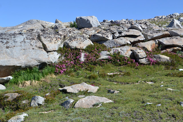
The way up is steep, but it is quite a flower garden.


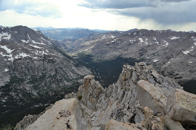
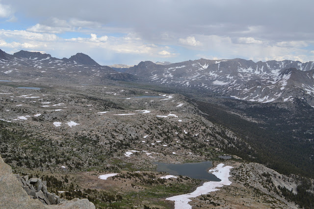
Unfortunately, the top is quickly discouraging. It is the sudden spurs that stick out of the edge that get me. The far side view is pretty stunning.


Working my way across and down the steep side is slow and draining of energy. All because wet feet are unpleasant. Eventually it works out and I have just a little bit to climb to reach the saddle.

I drop off half my gear. I do not need the 15+ pounds of food and bear canister to get to the top after all. I just need it to here because I plan to head down the other side and over to Elba Lake, which has trail down to the French Canyon Trail. A little lighter, I turn to scurry up the last part of the mountain.


It takes quite a bit of scrambling with some false starts to get there. The class 2 absolutely does not let up. I cross over one spot shuffling along a ledge with easy footing and hand grips, but a long way down. Exposure is not quite something I am used to thinking about on such a climb. There is an ammo can with a register from a year ago waiting to be signed. The old register was a thick sided aluminum can cemented to the rock, but the lid is gone and so are all the contents. Now this loose can must do the job.


I head down again slowly and carefully. Once basically into the saddle again, the rain comes up. Packing up again is in a gale with sparse rain drops driving into me. From above, getting down from Pilot Lake looked like a reasonable endeavour, so I change my plans from Elba to it. Getting off this saddle is certainly going to be easier and Elba is actually down another step from that, not to mention somewhat far off and out of my way. The wind dies quickly as I drop off the saddle. My route down dithers as my mind dithers about exactly where to stop for the night. Do I go down to trail now or in the morning? There is time, but the last bit of working over to the saddle really took a lot out of me. I am already staying closer to the destination tomorrow than planned, so I can certainly allow my legs a rest before giving them a challenging downhill. Wandering over to a spot that is high and dry and flat and sandy shows a mildly used camp area that is plenty big for me and quite a few friends, if they should happen to stop by. I find a spot to tuck away from the storm, but it already seems to be fizzling as I settle in.
Continue reading day 4 ⇒
©2017 Valerie Norton
Posted 12 August 2017
Liked this? Interesting? Click the three bars at the top left for the menu to read more or subscribe!


Comments