Bald Mountain and Hurricane Deck
Los Padres National Forest
Click for map.
I have been meaning to get to Bald Mountain next to Hurricane Deck for no other reason than that the USGS 7.5' quad is named for it. Of course, I checked it out for access after I camped at the top of Hurricane Deck three years ago. I sort of remember there being a spot along the way, toward the top of the deep cleft of Bald Mountain Canyon, where the brush between the grassy bald across the front of Bald Mountain and the Hurricane Deck Trail was only 20 feet thick. Or maybe 30. Or 40. But really, not all that thick. The difficulty looked like the top, which is not bald. With that in mind, I arrive at the parking for the Lower Manzana Trailhead, just short of NIRA on the road, a little after sunrise and sign into the register in the new register box at the trailhead and start on the 5 or so miles of trail before the mile or so of figuring it out.


The creek is noisy below. I cannot tell if it is a bit higher after the rain on the weekend. It might be. Potrero Camp looks about the same as we left it after the hazard trees came down. There is practically a road bed of rocks to cross over the creek to get to the junction on the far side. This is my turn, so up I head.

The trail has been rutted before and has the potential to be again, but for now it looks good. A few ticks are questing, but they do not seem all that active in the early morning chill as I brush them off. A thick patch of California peonies are generally budding, one blooming, and one already in seed. Admittedly, they seem to almost instantly be in seed once they bloom. The white rock layers come more and more into view as I climb. To the left, they stretch up into the larger of the pair of features called Castle Rock. To the right, they stick up in knobs along something like a valley. Little ones are nearby as the trail drops briefly to wander the valley area. It is a flat spot of rest before a little more climb.


A sign post marks the top of the trail and a second, shorter one is visible a little closer. The sign is gone. Still or again? I keep hearing how the trail is not what it should be although it has been fine when I hiked each bit. The eastern section with its long stretches through brush is the hardest to keep open. Here it is a barren top and trail is very clear along the edge. I am more preoccupied with the chaparral that starts just a few feet down the north side. These bushes grow close and thick and tall. There is no crawling under it or stepping over it or breaking through it. I will not be able to get through 40 feet, or even 20 feet, of this stuff without tools. It is still a little over a mile to where I want to try. Hopefully it will change in texture some before then.
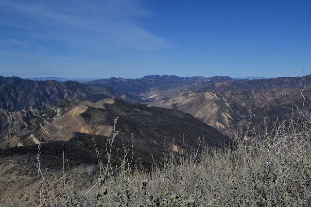
There are changes it the chaparral as I go. Sages get a bit more mountain mahogany (maybe...) among them, then the scrub oak starts to take over. As I reach the top section of the canyon, there are distinct game trails that start from the near cliff on my right and head over the top and down into the cleft. Whatever makes it, it is not big enough to push open a space big enough for me. It is seeming unlikely that I will get to the bald at all as I get to the high point of the trail without finding much promising. There is one spot I want to try, although I am not very enthusiastic about it.


Once at the high point of the trail, I feel like I may as well go on to the top of Hurricane Deck. I was thinking originally that I might go up it as well, anyway. The trail wraps around the side, but there was good use trail up the ridge three years ago. It does seem less likely I will get up Bald Mountain by putting the couple miles in for Hurricane Deck first, but it is seeming unlikely anyway. I feed my complaining tummy while pondering the water I can see down in the Sisquoc River. Following along from the landmarks, it looks to be around Oak Canyon, a bit upriver of Water Canyon. So it really does exist. Then I head on to the ridge high point.


A cairn marks the spot to leave the ridge and follow trail around the back side of the mountain, but I ignore it and start to climb up along a thinner trail to the top. This trail actually seems to have options to continue around the front, missing the top. I ignore those too. Hitting the top, it is familiar as the old camp spot that it was. The winds are light breezes again today.


I head down the far side in a whim to "complete the trail" since I have not actually hiked the part around the back of the peak. It is a lot worse than I remember. It is uncomfortably steep most the way, especially in the one spot where the only way through is a careful step over and around a few yucca plants. It does get back to trail quickly. Around the back, the trail bed is slanted and there are a couple dead bushes fallen down in the way. I clear what I can of them and a few cut branches in the trail. When back on the ridge and over the trail high point, it is once again time to glare at the problem of getting to this other peak.
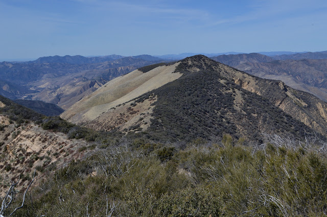
It seems silly to not at least try one or two of the steep openings even if they look nearly impossible. I try a couple dead ends, then come to a longer one. There seem to be paths heading somewhat directly up the grass on the far side of it. It is almost a dead end, but the mostly collapsed dead brush blocking it does have a way through. It is brushy with something that is not woody after that, so that is also something I can get through. It is not even very annoying, at least on the downhill. Then there is a choice. Off to the right looks very tempting. That would get to somewhere higher on the canyon. I almost take it, but decide to continue directly down. It hits the scrub oak and there is a cut. Suddenly the possibility of getting through is not so unlikely. It does not even look more than a few years old. The path continues nearly directly downhill. It is wide and comfortable to walk through and it drops to a spot where the bald comes right down to the bottom of the canyon. The trails up the other side are still right ahead of me. The first obstacle is surmounted. I climb and set off across the grass, trying to stick to animal tracks on the steep hill.

Once on the bald, it is time for the next part of the plan. Traverse the bald. First, I want to get past the brush dropping down from the first peak, then I want to climb up to where the chaparral is rather thin on the top and eventually swing around to the right and climb some more into the brush. The very last bit it still uncertain. The parts that involve navigating in grass are easy, especially if I keep to the game trails. The make a flatter surface to walk on that is much more comfortable than the slant of the hill side. When I get to the top, there is a very distinct trail, but it seems to have been made by something rather short.

As I near the top and the brush starts making its way down the bald side again, I make my way to the right as planned. I work around and up. Not working up gets into some uncomfortably steep dirt but working up gets into the brush. At least there are bear tunnels. I think I had noticed before that bear really really likes to stick to the ridge, but maybe not quite so much as it hits me as I look at the evidence on this mountain. Bear could easily travel the grass lower down. It is not even that much lower down. Instead, bear has come up here around the very top of the ridge and bashed out the lower branches to make trail. There is nothing for it but to take a few short crawls along that bear trail and work the final bit to the top.


I can see just enough from the top to be sure the ridge is heading down again on the other side. It does come to a slightly distinct top. As expected, there is not much to see from up there, just brush. I retreat to a little bit of a view, then retreat some more skipping the steeper side in favor of a slightly different selection of bear tunnel at the end. It works out just fine. Then I have to get back along the bald and find the bottom of that trail through the scrub oak again. It works out just fine too. I do not see a different route back out at the top where things get annoying for going uphill, but it does seem to be a short way from my most promising possible spot as found on the way up. (I really should have marked that with the GPS at the time.) I may have been looking too much for where I got through and not enough for where a cut track might continue. It still worked out just fine.

Back on trail, there is nothing left to do but to retrace my steps back down the little bit of Hurricane Deck, back down Potrero Canyon, and back up Manzana Creek, maybe see a point of interest along the way. Also, to point out to the backpacker setting up in a rather ridiculous spot that there was a much better one not too far down the trail. Hopefully I am not too cryptic about my directions. The spot he is trying was still frozen at 9 AM this morning, among its many faults.

Oh, and to realize in the last quarter of a mile that I never turned off my lights. That that little car just ahead that shows not even the slightest bit of shine at its front in the gathering dark does, in fact, have the headlights switch set to "on". But that is another story of minor misery of chill and hunger with almost certain rescue in the morning. It is nice to finally get to use my nice long set of jumper cables? Not really. I try not to let it dim the Bald Mountain triumph too much.
©2018 Valerie Norton
Posted 8 Mar 2018
Liked this? Interesting? Click the three bars at the top left for the menu to read more or subscribe!


Comments