Whitehorse Canyon and Conejo Ridge
South Ranch Open Space
Conejo Ridge Open Space
Click for map.
The Conejo Open Space Conservation Agency has offered up the 2018 Open Space Challenge, asking the public to "experience" a selection of 10 of "our best trails" with a prize drawing at the end for those who do so and report it. The local geocacher community contains a few avid maintainers of COSCA trails, so they set out to complete the challenge by including each listed trail in a series of approximately 7 mile hikes and inviting geocachers at large to join them every other Sunday. The challenge runs from March 1 to May 31, so there is plenty of time. Each route was put together by the fellow who built the Ventura County Trails web site, so there is practically professional trip planning. (He is also a local geocacher. There are clues scattered around the site.) Still, looking at the suggested route superimposed on satellite imagery, it looked like we might want to have it in at least one GPS just in case some of it was hard to find. He is not coming along to point the way. This particular hike was planned as a car bridge, but once we met up at the end point, it was decided that there was no reason for it to be a car bridge instead of a lollipop (except that sending a group of geocachers down a trail with no geocaches is a good way to gain a few) and we all proceeded to the start point leaving no cars at the end. As the start is not the most straightforward place to find parking, comedy ensued while all but one went somewhere else, that one looked around and assumed he must be in the wrong place since everyone else was not there, and finally all managed to to sort it out in another 10 minutes or so. We head out across the bridge to the trailhead nine strong plus one extra. (I refuse to call anyone a "muggle" just because they do not feel like signing logs in a "global treasure hunt".)

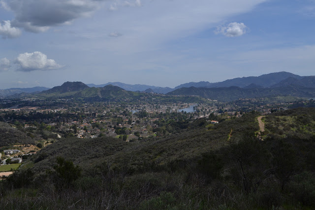
There is a sidewalk to get across from the parking to the bridge, but we miss it. The bridge crosses a wide wash with a couple of puddles in the concrete below it, but otherwise dry. The trail is really a utility road behind a car gate. It drops almost as deep as the wash and there is finally a sign identifying it as it starts to climb again on the other side. Birds are singing enthusiastically as we take the gentle climb. It seems odd, but most of them are on the side of the gated community, but I suppose there are more and bigger trees there. We at the front are getting up some good momentum when suddenly there is discord from the middle because we walked right past the first cache on the trail. We double back the few feet, but the middle is perfectly capable of finding it without us. The next one is a little way up a spur trail, and most the group heads that way, then further up the spur on to some more that enjoy some nice views of the local lake and Boney Mountain.


We head off on another little spur on our spur to find that, after going over a nice rock outcrop, it reconnects with the main road. The recent storms have dropped snow on a few things that would not normally see it and way out north is a mountain I should probably know covered in the stuff. It is a bit distracting trying to figure it out. It certainly does not look like Pinos. Pine Mountain? What should be north from here?

Once back on the main road, we resume our planned route. We probably added almost a mile to it wandering the ridge area, so it will no longer be 7 miles.

There is a brief bit of a discussion as we pass the last cache along Whitehorse Canyon before the one marking the end about how there are absolutely no caches that way and maybe we should ignore it and go this other way. It ultimately does not fly because that is the trail we came along to hike and we will be coming back that other way anyway. Besides, if they could just see past the next quarter of a mile, they would see that there are caches that way. And so we finish the pleasant stroll through the canyon and wondering where these side roads go.

As we reach the end of Whitehorse Canyon, we are on another major utility road. At some point we will curve back to the east, but for now we head west and then north and then northwest on what is clearly just a spur. It is where are planned route goes, though. There is not quite an obvious connection to the spur, but there is use trail up on the ridge not far from it. It is a brief steep climb to get up to it, then a little less steep as we go over the top, then painfully steep as we head down the other side.


Halfway down the ridge, there is another distracting geocache off trail. This one has some special points going for it and we want it, so we make a plan. We head off for an even fainter trail that travels much the same route. Since it is used less, it has better footing, but it does miss the cache by as much as the original route, so we must spur off into the brush for it anyway. Ultimately, it seems that only three of us want it because the rest take to sitting and eating lunch. And probably pointing and laughing. We three come away triumphant with the log signed and only 1 tick each found on the way. The group eats a bit longer, waves to a pair who can not stay for the whole thing and are heading back now, then connects back up with the original planned route to wind along more roads.

I find myself in the lead as we seem to be heading south when the plan continues northeast. I check the track and indeed, we have got off it. It is only 500 feet or so, but there did not seem to be a junction back there. Suggesting that as I have just missed the trail, perhaps someone else wants to look for it comes up with no takers, so I end up in the lead as we look again. There is a thin trail in the grass. This is the part of the trip I wanted to have the track in the GPS for. Again suggesting that as I had just lead everyone astray, maybe someone else wants the lead comes up with no takers. Once the trail is found, though, it is easy to follow. There are consequences to being the first along it: ticks. Every time I look, I have a dozen or so collected on my trousers. It is nearly as bad as McPherson was in January.

There are snips on bushes as we pass. Someone has mildly established the trail we are on. It takes a left turn to climb out of the canyon and end at the better used ridge trail at the top. Here I finally figure out how to shake the lead, not that it is needed anymore. While waiting for the rest to find their way along the little more than game trail, I take off the wrong way on the ridge trail for a distinctive rocky peak and one more geocache.


I am a little surprised that no one else also came up to the peak and the geocache. Everyone but Don has taken off the other direction instead. As I get back to the junction, Don asks about its health. He is responsible for it. We start to climb after the others, some who are feeling zippy and some who are decidedly not.


As those in front stop to look for and sign geocaches and those in back simply note where they are, we start to collect up again.

There are lots of junctions along the way as we wind back to Whitehorse Canyon Trail for our return. The trail the original plan calls for heading out on breaks off just before we get there.

The group stretches out again as they roll down the last, long downhill toward the cars. The final accounting for our trip comes in around 10 miles. We did add a few things here and there to the trip.
©2018 Valerie Norton
Posted 22 Mar 2018
Liked this? Interesting? Click the three bars at the top left for the menu to read more or subscribe!


Comments
There will be a post-Challenge event to give out prizes. It is tentatively scheduled for Friday, June 1st at 6PM, location TBD.
If you are enjoying the Challenge, please consider donating to the Conejo Open Space Foundation at http://cosf.org/donate/. If you have any suggestions for future Challenges, please feel free to pass those along too.
Thanks again for getting out into the open space (and supporting our sponsors – Newbury Park Bicycles, RoadRunner Sports, Billy D’z BBQ, JOi Café, and REI-Oxnard)!
--Steve Bacharach
Conejo Open Space Trails Advisory Committee Chairman
{coschallenge@gmail.com}