The Playground and little excursions on West Camino Cielo
Los Padres National Forest
Click for map.
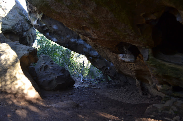
Next up is poking around some rocks! There are quite a few rock outcrops up on Camino Cielo, but the Playground might be the largest of them. Others are closer or offer more solitude. A random scattering are popular with climbers. The usual parking is empty as I come up. This is surprising for such a sunny day even if it is a weekday. From the parking, use trail rolls down the hill with little ups and steep downs to a cluster of oak and bay beside tall rocks full of small caves. From there, the trail splits and splits and splits again to roam over, around, and through the rocks as people have seen fit. It is quickly clear why this is the Playground.


I follow a track around to the right. It is large, but still seems to drift into nothing as options present themselves to climb up into this set of rocks. Working downward, there is more trail again. Crossing below the rocks, there is quite a lot of view to view.


I go clambering into a tight squeeze and then up and around on some large handholds to the top of one large rock. A pool of water sits up there, undisturbed even by the birds. There are anchors bolted into the rock on the far side. I found one of the spots the climbers like. I did not bring my gear up with me, so I head down again and find another rock that is easier to get to the top of for a bit of lunch. My stomach is screaming and it is getting a bit late.


I have to admit I am not quite feeling like doing too much of the Playground. Maybe it is my shoes. These are not the stickiest I could choose and when I find a wet rock, they really do not grip. I decide to head up again and just look around a little more in other places. There are plenty of details to be noticed on the way up that I missed while clambering downward.

Back at the car, I head a little further down the road to a nice big pullout before the gun club. There are vernal pools and should be a trail heading north. The only one I can find that goes anywhere quickly crosses the gun club fence. Doing this seems like poor judgment to me. I wander back along the road looking for a trail north with no luck and turn around to head down by an even bigger pullout across from a water tower that is actually dribbling from being full.

There is trail down from the turnout that joins up with a cut that looks rather like a fuel break, except it runs below the ridge. People have walked it as it drops to a wide creek bed with no water. It looks like people then just follow the creek, which is quite open. I have no desire to do so. The map would indicate this is another way into the Playground anyway. That is, if it just follows the creek down.


I head back and follow the trail past where I joined it to the west. It has a couple routes, but both just curve upward and join again, quickly getting to the road past their join. I head back to the car. On the south side of the road is another barricade blocking an almost vanished old road, so I head down the trail near it to see what it might do. It passes by a post marked "no shooting". It is hard to read and, since most people seem unaware that target shooting is limited to designated areas, the area behind it is a bit of a mess. This does not seem to be what the usual users of the area are here for as the trail continues past the messy meadow below the road to some more rocks further south.


There is another trail to the left that looks to be going somewhere else. I choose right just because it looks more used. It heads down to a small outcrop of rocks. They have chalk all over them. Some spots seem a little suspicious as hand holds as though someone was actually decorating the rocks with chalk.


After a bit, I head back up and away.
©2018 Valerie Norton
Posted 21 Mar 2018
Liked this? Interesting? Click the three bars at the top left for the menu to read more or subscribe!


Comments