Posts

Showing posts from September, 2019

Newspaper Rock and Indian Point

Image
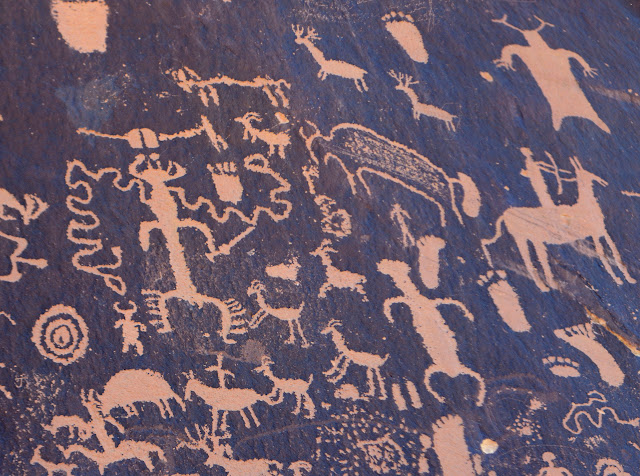
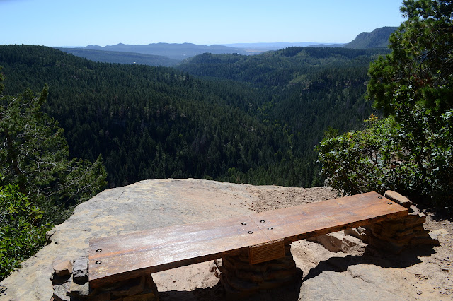
Newspaper Rock State Historic Monument Indian Creek SRMA, BLM Click for map. I have been to Newspaper Rock before, but it was a rather long time ago. It was probably about the time my dad got his 4x4 pickup truck and decided the family vacation would include Canyonlands where he could take this shinny new truck over Elephant Hill and up (likely down) the Silver Staircase and out on the Island in the Sky to see the confluence. I recall that last one not having such a bad road in and there's a paved option of sorts. I also remember one road in The Maze where a little white Corolla came up out of a canyon and we got to the top and my dad hit the brakes and perched there for a bit before deciding it probably wasn't deadly and putting it in 4-low as though that would save us if it was. Then again, I seem to remember him doing something similar in the Bronco with its push button 2WD-4WH-4WL changing and feeling like a button with a light was not so settling as a proper st

Abajo Peak

Image
Manti-La Sal National Forest Click for map. I decided next up would be Abajo Peak, the high point of the Abajo Mountains. It was an easy choice. I'd almost tried going for it with my previous loop, but didn't want a 20 mile day. I figured it would add about 6 miles to that loop that turned out to be quite a bit longer than expected. I've got another cobbled together route for this one. I mean, I could just drive up it (depending on the quality of the road), but who wants to do that? Instead, I've traced out some ridges for a cross country route up and then trail and road to come back down. The road, 4WD on my map, actually looks in good shape and is marked by a horizontal number. I think I could drive it until the trail portion and make a much shorter day of it, but then there goes my cross country challenge. I'm kind of set on the ridges now, besides I sort of expect there to maybe be trail that way. Surely the locals like the idea of going up the local h

Robertson Pasture, Twin Peaks, and Spring Creek Trail

Image
Manti-La Sal National Forest Click for map. The roads seem to be increasingly dominated by rough things, at least on the map, so I wasn't sure what I could do. I plotted out a loop of 4WD road and (motorcycle) trail and a little bit of paving from an easily accessible overlook for a get-to-know-the-area exercise and figured I should have more ideas later. The easily accessible overlook is the Harts Draw-Canyonlands Overlook, or so it says on the map. It lacks any road signs to point it out, but once there has a nice set of sighting tubes to point out the landscape. That can't be bad. It includes Canyonlands! A series of tubes for sighting things like Shay Mountain there on the left, which is hard to miss, and a few things down in the canyons to the right. Lots of canyons below, some of them part of Canyonlands National Park. So on to the first little bit of paving before turning onto the first bit of 4WD road. There's plenty of shoulder and the cows ha

Madden Trail

Image
San Juan National Forest Click for map. There were trails up Silver Mountain, I think at least two. They look well used. I went investigating a road in Mayday I thought would be a promising start, but if I found it, nearly a quarter mile south of where the map had it, the only mark on it is a public notice about Sunrise Mines starting operation again and requesting public comment about that. Since they are starting in 2017, that comment period is probably up. I noticed some unwelcoming signs for Sunrise Mines on my first pass through, so I think some of the public will be having their say for a while longer. Right up until 2027 when this window of operations cease, perhaps. Combined with absolutely no parking nearby, I decided that wasn't promising after all. One of the trails I was seeing seemed to come down toward a mystery road just on the other side of a small lot of private property next to Miners Cabin Campground, so today I'll try that. The road is marked &

Parrott Peak and Madden Peak

Image
San Juan National Forest Click for map. No difficulty in getting to the hike I have planned for today. It starts off right across the road from Miners Cabin Campground where I'm staying. (Which is free and has a bathroom. No tables. For that, you've got to pay at Snowslide.) My plan is basically to go up an old mining road to Lucky Discovery Mine, then make my way up to Parrott Peak. From there, continue on up the ridge to Gibbs Peak, which looks to be about where the ridge starts getting rather complicated. There is a prospect high on it that once had a bit of road that connects to Allard Mine, which still has a bit of road down Bedrock Creek about a mile up the main road. It has quite a nice waterfall right at the bottom and enough red rocks to suspect it is actually Redrock Creek. I'm not tied to this plan, though. Judging by the amount of ridge line I managed on Lewis Mountain, I will not make it anywhere near Gibbs. My main goal is Madden Peak and the benchmar

Highline Colorado Trail, Grindstone, Bear Creek, Sharkstooth loop

Image
San Juan National Forest Click for map. I really want to go on the high trail, so I decided to just drive up as far as I could and thumb it and let the chips fall where they may. The chips are definitely going to fall. I have a 20 mile loop planned, which is getting a late start. I will definitely be getting back out after dark and almost certainly not be able to get a ride down. (That's nearly 6 miles.) Up is easy. Everyone is only going about 5 MPH so they don't see much problem with stopping a moment. Unfortunately, I decided to just park where I parked before and then was insufficiently clear, saying "the top" when I meant to say "the observation point", so I missed out on the first ride when they thought I wanted to go up 124A. They don't know I've already been. I would have arrived 30 minutes earlier and 2 miles fresher. Instead, I found a ride up with a wedding party that decided a bit of steep and wet wasn't something they want

Lewis Mountain and Columbus Mine

Image
San Juan National Forest Click for map. I set out to hike a bit of the Highline section of the Colorado Trail, but the "improved dirt road" marked on the map ran out of maintenance a mile or so after La Plata City (one of the many small free campgrounds along La Plata River) and just below the road to Tomahawk Mine, I passed over a bit of road that was all rock-throwing and I-need-power-on-a-rear-wheel-now and will-I-hit-that-rock-on-something-vital? and generally not something I should have gone up in the day and certainly not something I want to come down in the dark. I turned around and settled on hiking County Road 124A, a Jeep trail, up to Eagle Pass, then continue on to Lewis Mountain with thoughts of the Snowstorm benchmark further along, then County Road 124, the one that is not nearly so good as marked on the map, down again. This is still after the end of maintenance, but while some of it might look scary by headlight, none of it will actually be dangerous

Sliderock Mountain

Image
San Juan National Forest Click for map. Out for more exploring, I went to drive out to Cemetery Flats and see what happened. Unfortunately, the road was a bit too rough by Rands Point, which is to say I'd already driven over something I probably shouldn't have and decided to park before I did it again. There's plenty of parking there although at the moment it is take up by a bunch of hunters studying the far side of the canyon for elk. I haven't seen any since the bunch on Endlich Mesa, but hunters sure are easy to spot. Well, these aren't trying. It's quite some view from Rands Point. Noticing a red cliff and band of white the trees don't like on a nearby mesa. Silver Mountain (right) and Baldy Peak behind Bald Knob, with some area to look for elk. The row of peaks from Snowstorm on the left to Sliderock on the right. Snowstorm is near Lewis Mountain and Sliderock is just up the road. I wonder if I want to go up Cape Horn on the

Junction Creek Colorado Trail

Image
San Juan National Forest Click for map. In spite of seeming like a worthy trail to hike end to end, my actual knowledge of the Colorado Trail seems to be certainty that it goes through Breckenridge, where I've chatted with a few hikers on their first resupply after a week on trail, and a general thought that it might have one end sort of near Denver and another kind of near Durango. Well, here I am basically in Durango, so it must be around here somewhere. These very last (according to the direction most people hike it) miles of the trail seem to have their own names. The finish is Junction Creek, which comes after a short Sliderock section, which comes after some Highline. I was tempted to start at the parking a mile up, but decided out of some misplaced desire for completeness to start at the bitter end. The lot is large and nearly full. Someone has left a cooler for the hikers that has collected some camping gear beside it. I wonder what they've stuck in there for

Animas Overlook on Barnes Mountain

Image
San Juan National Forest Click for map. Well, I managed to put a hole in my "new" Altras. I noticed a thin spot in the side as I put them on for Dark Canyon and I noticed I could stick my finger through as I put them on for Cave Basin, so now I have a glob of Shoe Goo filling it in. It's a weird spot, on the inside of the shoe right by the ball of my foot. I must have scraped it across the trees as I "hopped" over them through the major burn down West Mountain. They barely have 300 miles on them. That's only like 3 weeks to the through hikers that these are supposed to be popular with. Then again, they do tend to hike cleaner trails. So now I want to see if this Shoe Goo will hold. I've usually used E-6000 to fill in the holes that eventually develop, but I seem to have got a collection of adhesives and the Shoe Goo is a little harder and should be more tuned to the job. So I'll test out some trails that OpenStreetMap shows in the area, sto

follow by email