Madden Trail
San Juan National Forest

Click for map.
There were trails up Silver Mountain, I think at least two. They look well used. I went investigating a road in Mayday I thought would be a promising start, but if I found it, nearly a quarter mile south of where the map had it, the only mark on it is a public notice about Sunrise Mines starting operation again and requesting public comment about that. Since they are starting in 2017, that comment period is probably up. I noticed some unwelcoming signs for Sunrise Mines on my first pass through, so I think some of the public will be having their say for a while longer. Right up until 2027 when this window of operations cease, perhaps. Combined with absolutely no parking nearby, I decided that wasn't promising after all. One of the trails I was seeing seemed to come down toward a mystery road just on the other side of a small lot of private property next to Miners Cabin Campground, so today I'll try that.

There seem to be rocks nicely edging the ford as the road goes through La Plata River, but maybe that's a consequence of the ford since some of them are a little wobbly. Still, I can get across without getting my feet wet. Then there's finally a private property sign. Complete with rape joke. Ha. Ha. These seem to bring the greatest humor to the sort of person that would be most traumatized if it happened to them. Anyway, never mind. I should probably consult Alltrails, which does have an entry for Silver Mountain. It's just not very accessible from here. Now I find myself simply wanting to wander around and figure out a little of the maze (well, not so much of one) of road and trail that is available on the other side of the main road. First up is that mystery road that sits unsigned across from the campground entry.

This road does follow the route, more or less, of the road shown on my USGS map going up to Lucky Discovery Mine. It clips a corner of private property, but that just means a vanishing spur signed against trespass and another 1986 surveyor monument with the same license number. A little further is a spur into a tight little canyon with a campsite at the end. There are a few recently cleared trees, but it gets less and less use as it winds upward until it looks like there has only been a tractor recently. The tractor dug out a small tank at the side and quit. Trees are down, but they are thin enough that people have attempted to drive over them. One looks like it might have got in a good bit of retaliation once. The road narrows down to a single track trail about 100 feet of intersecting the current route slightly west of the intersection. No wonder I missed it even though I passed it twice.

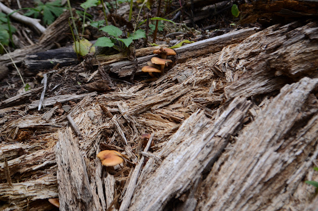
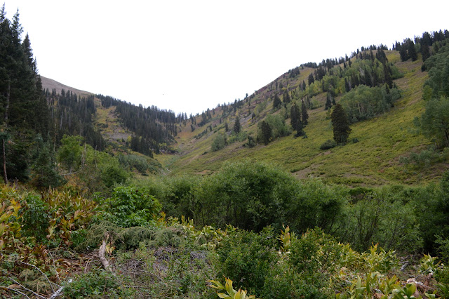
So what next I think is going to see what the rest of Madden Trail gets to after it was looking like a pusher road. The junction is just over a little rise. The road at first is wider and more solid under foot. I can see where cuts have been made and where the road was once level even if it isn't now. Where the road has been blocked about halfway along, it becomes softer and starts to curve more. I can see a few spots where a tree has been removed. It twists more after the point I turned around yesterday and starts dropping more quickly into the valley around Madden Creek. Salt blocks have been dropped for the cows in a wide area where road squirms in circles around the trees. I expect this was once the end, but clearly some road pushers wanted to keep on going. It climbs a little by the willows around the creek and then turns back into the trees to climb, trashing about, trying to find room, trying not to quit. Finally the forest had the pushiest of the pushers surrounded and the tire marks yield to the green among a delightful growth of mushrooms. Only a few other tires have made it nearly so far as the last desperate pusher.

This is presumably where I would have been hoping for a trail coming from Madden Peak had I come down the north side or off Star Peak. I drop back to the interface of willow and forest where there seemed to be trail. There's even at least one set of footprints. Mostly it looks like the cows have been pushing through here and they are less likely to have wanted to go to the peak. Still, I thought I saw hints from above, so I go on. Trail used to be a little higher up among the first few trees, but avalanche activity last winter broke a few of those and blocked it so that now closer to the willows is more popular. It is the face whacking branches that make me think people aren't making much use of this. They'd have broken or cut those by now. There aren't a lot of cuts. Okay, there aren't any that I notice.


I think about having a peak goal for the day after all. Just 1700 more feet to climb and getting less. There is a brief surge of desire, but it flows right back out again. I'm just looking about and going to have an easy day. More and more trails break off to cross the central area with willows and other brushy stuff about as tall as I am. The ground looks churned by debris flows, but a few of the paths are suitable for lazy walking human travel. They then climb into the trees and look more and more cow like. Cows just don't come up very high so their trails don't clear much above the waist.


So after crossing, I turn around and cross right on back.

It is starting to feel a bit endy, but I shouldn't be too far above that trail to Gibbs Peak. It seems unreasonable to think I will recognize it from any potential cow path along the way, but every step of it seemed distinctly human used before. I'll go for it, just a little cross country. There are very old blazes cut into the trees on the way down. That seems nonsensical.
Indeed, the trail is still distinct looking to me. I turn and follow it a little way further up as it crosses a large bench that various forks of the creek come down. Gibbs could be "mine"! But I only go a little way, then turn back. It is longer than I expect to the short road pieces. I follow the other one with a bit of trail up to see if it goes to the mine. It does. I then follow the others as far as they go. They don't go far. The trail had come in at the end of one and leaves just before the end of another. A third is below that and doesn't go much further. There must be prospects I'm not noticing near the ends.
So I follow the trail the rest of the way down. So that sorts out that, I suppose. Anyway, I've filled in my map a little.
©2019 Valerie Norton
Written 16 Oct 2019
Liked this? Interesting? Click the three bars at the top left for the menu to read more or subscribe!


Comments