Lewis Mountain and Columbus Mine
San Juan National Forest
Click for map.
I set out to hike a bit of the Highline section of the Colorado Trail, but the "improved dirt road" marked on the map ran out of maintenance a mile or so after La Plata City (one of the many small free campgrounds along La Plata River) and just below the road to Tomahawk Mine, I passed over a bit of road that was all rock-throwing and I-need-power-on-a-rear-wheel-now and will-I-hit-that-rock-on-something-vital? and generally not something I should have gone up in the day and certainly not something I want to come down in the dark. I turned around and settled on hiking County Road 124A, a Jeep trail, up to Eagle Pass, then continue on to Lewis Mountain with thoughts of the Snowstorm benchmark further along, then County Road 124, the one that is not nearly so good as marked on the map, down again. This is still after the end of maintenance, but while some of it might look scary by headlight, none of it will actually be dangerous to drive over. My one concern is that there is a lot of private property along the road, but surely a county road is not closed to the general public. Even if it is smaller and also doesn't get much maintenance.

The first hint of the private property the road passes through is a gate with no road behind it with demands against trespassing made in various long standing ways. A flatter line runs to a gap over the river and then quite obvious road goes up through the trees. My map says "Gold King Mill (Ruins)" off in that direction, but since I'm not having a day of seeing the marked ruins along the road, or a fair bit off of it as this is, I continue on to the bridge over the river and up the other side. The bridge is built with wooden reinforcements where tires cross, except they are set so far apart that any ordinary vehicle can only travel on one at a time. The map says the road can be gated, but there is absolutely no sign of such a thing. Past that is an empty but decidedly unabandoned bit of property that could be a holiday camp. The map indicates a mine on it, too. A few driveways marked "private property" follow until the end of the first, small section of inholding and it is just trees and Lewis Creek burbling below.


The road offers very little opportunity for oncoming traffic to pass. At the first turn, a road almost as well used continues on along the side of the creek. Camp site perhaps? No signs indicate what might be beyond and the map doesn't show inholding, but it may have missed something. I turn up thinking I might be exploring, but that is the road after all. The mystery shall remain. Another possible camp site comes as the road reroutes a little higher than it once traveled. I am following the older section with my eyes as I come out to a meadow and spot an old automobile chassis upon it. The reroute must have happened a long time ago.

It looks at first like the old road dropped off a cliff, but it just goes over a hill and crosses a tributary at an oblique angle. Now the road goes directly across it before starting into the much larger chunk of inholding.


The return to private property surrounding is signaled by another mystery road. I start to explore before finally spotting a sign high on a tree where the casual miscreant can't remove it. The mapped inholdings look like a vast array of mining claims stuck next to each other and overlapping like strips of paper-mache. It's probably not just one big piece. A little further, and occupied by some cows, is another sign hanging over an unused road to some buildings, one collapsing. They look almost ranch-like, but just past them is a massive, teetering old building with a massive chunk of iron machinery somehow still held up on the second floor which is unmistakably part of a mine. The nearby holes in the ground and tailings are pretty good clues too.

I am passed by a Jeep going along at don't-lose-momentum speed on the steep road of loose rocks. Two people with identical packs. Maybe they're going for the mountain too? Further up is a place that looks like a summer home with the related mining areas blocked off and a bit of water collected from up the road. There isn't a lot of water up here.


Up above, I see two figures walking the road with their identical packs. A little while longer, I see why. There's a spur road next to a sign stating there is no turn around before the gate at the pass above. No motor vehicles beyond, except those allowed by Judge Babcock's 5/17/99 decision, adds a fallen sign. Besides the Jeep, the spur is occupied by a Durango and a Silverado with a heated tent setup. I'm surprised to see the longer vehicle. That second turn on the way up is a doozy. My own car is visible 2000 feet below. It's been joined by a couple other vehicles. I hadn't expected that, either the first bit or the second.

This gate is real and locked and has no turn around as promised, not that a few ATVs haven't tried. I pass it and climb along the road a little longer before leaving it to cut back to the pass. Eagle Pass is an excellent spot to hang out and even get a weather report. There is a weather station on the peak just south of me, so at least the current conditions should be accurate. Someone must qualify as "allowed by Judge Babcock's decision" because there is a black Jeep crawling along the road by Jennie Lind Mine on the far side.


There is a faint trail along the ridge line to climb along, but I'm not sure if it is from people or goats. There is a distinct lack of cairns although there is plenty of material, so I suspect animals. I found the pair with identical packs eating partly down from the weather station, so I guess they weren't going far. As I climb, I feel fear which is, frankly, outsized compared to the terrain. It is like there is some well of fear that's been pushed down and ignored is overflowing. Maybe I've been throwing myself at uncertain loops too much lately. Maybe it's some low grade constant fear. (In case you are wondering, no, poking around the countryside is not a sustainable lifestyle and, yes, I ought to be looking for a job. Something math heavy that sees a Physical Chemistry PhD from Caltech as a plus would be ideal. Especially with programming involved.)


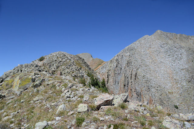
And now a brief word about maps. For topography, there is usually nothing so detailed as USGS, and that's what is needed to head out cross country. The old maps are getting dreadfully out of date as far as trails are concerned. They also are only available in raster formats that can't be zoomed in very well. The new ones just don't have any trails to be out of date, but as vector formats giving infinite zoom. The Forest Service has a set with their assets, that is trails and roads and campgrounds and whatever else, added on top. This should be great. Unfortunately, the contours seem to have been smoothed out. They aren't allowed to stack up on top of each other as they need to for tall cliffs or just very steep hillsides. Very annoying for Lewis Mountain and Sliderock Mountain, the very small contours at the top that show where the actual peak is have vanished. Infinite zoom is no good if the landscape is smoothed out and simplified away from reality.

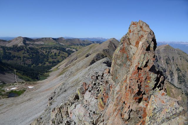
With the height marked on the leftmost peak, one might think that is the high point. It certainly is not. It might be to the left or to the center of the larger area defined by the 12600 major contour, both locations that are 12720+ feet high according to the old map, but it's really hard to see at the best zoom available. Anyway, for climbing mountains there's usually more information needed anyway. Peakbagger marks it as the left bump of the larger area with a height of 12682 feet. No idea where they got that, but I have a primary target. I seem to be working around the side aiming at the next one instead of to the top of it, so I better change tactics and get back on that edge. It had looked like trails were going around the side. Animal trails and happenstance lines, probably. When I get back to the edge, the trail that had vanished is back. The top isn't too much further up. It has a wind shelter but no register. Oh, and some more new view.


I can see my car from here, too! Well, I can see a dark spot on the side of a dirt road with a slightly smaller dirt road going off right where the junction should be. It is 3000 feet down. There are even more mountains off to the east than there were from Sliderock, which is a long lump with bald spots on the side and a road across the front connecting the ridge on either side.


Now, what do I want to do? Find that benchmark over there, of course. I wonder why it is there and not here? The single entry on Peakbagger for this peak has a writeup that calls the ridge from here to Snowstorm a great introduction to class 3 ridges. I'm not seeing that right now, but it is a bit rougher than I remember from looking across Junction Creek to it. (This is probably because I was actually looking at Silver Mountain.) What I do see is more like class 1 with a lot of exposure, which seems like an oxy-moron. There is a nearly smooth, wide enough for comfort (if not for the drops on either side) trail along the top, but there are drops on either side. I stow my poles and camera because someone told me I'll need to actually climb at some point, but it makes me feel like a wobbly, top heavy creature as I walk the trail. That feeling of an overflowing well of fear is gone, replaced with a desperation for something to hold onto.


It seems to have taken me over an hour to get the last third of a mile and I'm feeling quite done with this ridge. I still haven't found the class 3 bit, but it does get to be class 2 as I inch toward a cleft I have identified as my first bail point. The top hand holds need some testing, but everything below is big and easy and solid for the little down climbs. It is already 4 when I get to the cleft, a pace that suggests sunset by the time I get to the benchmark. It does look to be getting easier, but not easy enough. The Jeeps that have been oozing along the mine road below have all vanished in anticipation of the afternoon thunder storms that aren't supposed to happen today. I think I should follow them and get down, down, down. I'll get to see the mine instead.
I was actually looking to get to the second cleft beside a stone pillar, but the first one looks close enough. I'm not really certain how I might get around the pillar, but I'm not trying that hard to find the way. Loose rock on a steep slope is how my trip down begins. I keep some solid rock to my left and always have something to hang onto until the slope eases a little bit. If these rocks were smaller, I might just plunge step through them, but I'm not feeling that confident at the moment. I go for a more controlled, backward stepping, letting each foot slide until it stops while leaning into the slope. It's sort of a slower version. When my feet start to find solid steps, I can get out my poles and walk the rest of the way. The slight ridges are a little more stable, the depressions seeming to gather the loose rock sufficiently recently that it hasn't settled. I can hear water running below the slight depression areas.


I could see the big mine shaft, covered in mesh, and some artifacts beside it from above, but smaller artifacts show up sooner than I was expecting. I seem to be following the route of the water they used as I find myself following a pipe made of sheet metal riveted in a spiral. I haven't seen that technique before.


From the road, I head back up just a little bit to see the mine up close. It has a sign with a little history and something on the reclamation. There is even a rough map of the mine from 1917. It was active 1896-1917, roughly, with everything coming by pack animal. It was "made safe" in 2008, which is presumably when the pack trail on my USGS map became the 4x4 road on my Forest Service map that the Jeeps were using. The grate is sagging disturbingly over the vast hole which drops 500 feet.
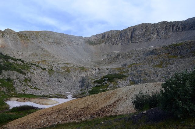

Then it's all easy road travel down. The 4x4 road doesn't seem all that bad, but there is a section near the bottom that is too rough for my little car. People have been forcing their way onto a smaller road to a lower drift of the mine. Besides that hole, I can see another higher up in the long cascade of waterfalls of the creek I was following down earlier. I wouldn't have wanted to follow it too much further. I can pick out two places where old trails used to climb up to the ridge I came down, though both rather north of where I was.


I am surprised to pass an old cabin, now just a few lower logs, and then a second weather station. This one looks like it might have a contraption to measure the weight of accumulated snow. I bet these two weather stations give very different information with one nestled down in the trees and one sticking out on a low peak. It's just a little more down to get back to La Plata River, but still with a chunk of road to go. There's lots of people passing both ways in the twilight.


It's not dark yet as I get back to my car. It still has its two buddies in the parking. One is a rented trailer left unhitched. I wonder what their purpose is, but not enough to stick around instead of heading down to get some food. Oh, what a day.
©2019 Valerie Norton
Written 29 Sep 2019
Liked this? Interesting? Click the three bars at the top left for the menu to read more or subscribe!


Comments