Ortega Hill and Ortega Peak
Los Padres National Forest
Click for map.
While watching the progress of the Thomas Fire over the south side of Ortega Hill, leaving the north side alone, I decided I would hike Ortega Peak again once the closure was lifted. This time, I would give Ortega Hill a try too. After all, it is the actual named thing. I do wonder what historically conspired to give that lower hill a name while leaving the bigger peak with only a benchmark. Bonus, it is unlikely to still be the miserable, masochistic bushwhack without a single view that has been reported by both groups that visited it in the last 20 years. Okay, so that last might be why I would even think about doing it when there is a better peak right next to it. The Thomas Fire closure was lifted a lot earlier than expected, but I remembered my musings eventually and here I am. A slightly early start because the days are getting hot. This one only promises about 80°F instead of 85°F of the nearby days. I brought two bags of water (about 5L) since heat, length, and being in a burn scar could all lead to wanting a lot. Right now there is a very stiff wind coming down the canyon and it is a bit cold. Since the gate is closed, I have three miles of road walking to do. I expected that. They are easy miles with only the last quarter or so really feeling like a climb.

According to the Forest Service, everything on the right side of the road is burned. The fire itself did not get this far, but backfires were set to make everything certain, then it started to snow. It was December, after all. The burn is barely noticeable on the meadow, but on the far side I can see a dark line of singed plants. It certainly did not get far. Those hills look mostly untouched by fire to me. The road drops to cross the Sespe Creek, which is just a few puddles upstream right here, right now. Past it is a new warning sign about the hazards of walking into a burn area. Weakened trees that may fall are a particularly important one on windy days like today. The weakened hillsides are important any day. Somewhere up there, it all turns into extra dangerous. The road is long and flat and safe across to the canyon carved by Cherry Creek. As I enter the canyon, there is a small arm of burn up on one of the hills on the far side. Other than that, there is only the set fire along the side of the until the first high pressure gas line sign. They seem to have looked at that and decided against continuing. Someone probably should have mentioned it to them before they even started. It is on the map. The fire burned a little extra on the obvious cut left by the buried pipeline on the far hill. The creek is flowing, but must sink into gravel before it finishes at the Sespe.


It is cool and not windy in the canyon. The water flow quickly grows as I take the gentle climb. The little bit of fire I saw on one hill must have only been a spot fire because everything is thick and green on the far side. It is still the lovely little canyon it was. With the easy slope and very little poison oak, all of which is easily avoided, there are at least a few who see it as a lovely kid friendly hike. Since it is above 4000 feet and north facing, it should be cooler than the surrounding area. I am certainly finding it nice. I especially like all the bird song that rings through it.


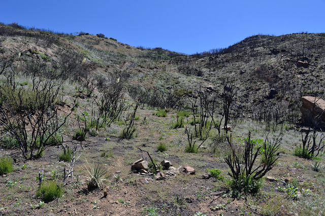
Around a corner, everything changes, at least on the far hillsides. The canyon is still green and flowery and full of birds, but the hill has been reduced to black sticks. I am surprised to see a few pine trees standing tall and green out among them. Most of the hill did not have pines and the burn is quite complete over that part.

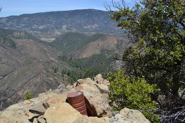
An old foundation of concrete practically in the creek draws my attention briefly. I wonder what it must have been. Then on, into the burn. It starts slowly. At first there is visual evidence of a low fire just through the undergrowth. Then it begins to take over. There are some very big trees up here. Most still stand with green at the tops. One came down across the road and was chopped and removed already. It would have been quite a challenge to climb over as it would have been a little bit of a challenge just to see over. Another couple burned and toppled off to the side sometime after the fire. The breaks are still bright in color. This is the sort of thing the sign is meant to warn about. At first glance, the pine trees are either green or fallen, but there are probably a few I am just not noticing yet. A bunch of smaller oaks are looking very poorly. There are certainly a few scary creaks from up the hill on my side of the canyon. The wind comes up as I climb, but the trees shorten.

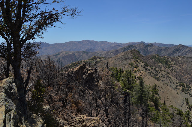
At the top, the wind is strong enough to try to take my hat although it is tied down tight, but there is nothing tall enough or large enough to really notice if it fell on me. Ortega Hill is definitely going to be a very easy climb compared to what it was the last few decades, provided the wind does not blow me over. It would be very hard to make it a bushwhack now. On the far side, the Upper North Fork Matilija Creek looks scoured. Supposedly every square inch of the Matilija Wilderness burned and from what I can see that is nearly true. There are some interesting patches on nearly flat spots at the top of a few ridges that still flourish.
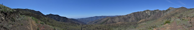


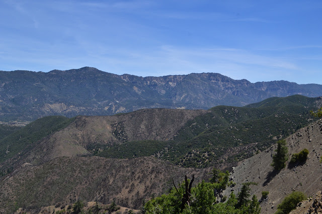
A few big rocks set across the top of the Upper North Fork Matilija Trail are all there is to mark it, but the trail is quite obvious. It looks ready to become a wash, but that is not actually a change. Shortly after the trail, the road is blocked with more rocks as it turns into Ortega Motorcycle Trail. A few folks have been up here on their bikes. There are more tracks here than there were on the road. They must only be interested in getting to the top. I suppose that is all I am doing today, too. I pause to try to take it in from time to time. Far out, through the haze, I can see a white line that puts me in mind of an eternal breaker, always moving and churning but apparently still. It is probably just the beach, but the eternal breaker idea is so compelling, I find myself believing in it instead. I keep going and pausing. One pause is for the thickest clump of blue dicks I have ever seen made doubly noticeable by their absence everywhere else. I pick out Old Man Mountain and Vulture Peak beside it. An easier climb now. I pick out the Santa Ynez Mountains high point. Easier climb and my signature is probably charred and unreadable. Eventually, there is my break off point to start on the old use trail to the peak. In the burn, I find myself more ready to accept that rocks might have just fallen that way rather than being a cairn. The one that marks the break off point is one of these except that it is right in the middle of what is clearly an old bulldozer cut.
I start up it thinking I really should have reviewed the route before I started. It has been three years and things do not exactly look the same. There are absolutely no cuts on the brush for clues and the fire can burn branches in a way that looks like they might have been a flat cut before, maybe. Of course, it is not the least bit difficult to follow the bulldozer cut. I reach the cut from the buried pipeline, looking rather excessive as an old three lane dirt road, and know I should have reviewed the route. I could follow the pipeline either direction or continue across it. All look equally likely. With some false starts, I take the right turn and climb to pipeline marker 28, somehow with its paint intact, where there is an obvious trail climbing. Now I feel confident again. Once I get to the ridge, there are no turns, just the choice of cliffy trail on the north or thick brush on the south except all that on the south burned.


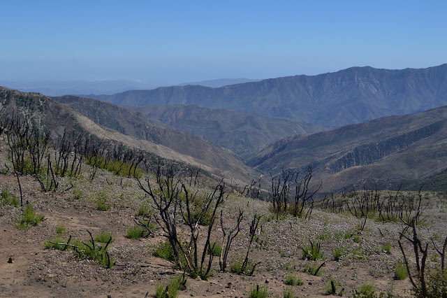
Of course, climbing high brings more destruction into view. Should I cry or be fascinated? Fire is always a part of this landscape. It should not be so big as this last one and it should not happen in December, but it is a fact of life. There are almost no burned sticks standing without a bit of green starting up from the old roots. This land did not die with the fire. I choose fascination, though I am sorry I have no good photographs of my previous trip to compare with the ones I am taking today.


The trail is still visible up on the ridge, especially those spots where it creeps out onto steep rock ledges toward the north side where the land drops away suddenly. The trail is easy to invent on the south side. I find myself trying to follow it even as it edges out toward scary drop offs. Having walked it before and survived, I may be think of it as safer than it really is.


Without too much attempt to climb the slight false peaks on the way, I find myself at the top. Tall oaks around the peak seem to come in three rows. The south side ones are singed and look dead, the north side ones are green, and the middle ones look to be struggling but will make it. The register, up on its big rock, is untouched. Well, almost untouched. Two people did sign it last year. They were together and should have been three, but one decided against traveling those exposed pieces of trail. (They all went up Ortega Hill first, so would have been tired and bloodied. They recorded it on peakbagger, so I knew about them already. The only thing that surprised me was that I had to toss off some trimmings they left on the trail and the fire did not burn.)


I remember there being a benchmark on the rock, circa 1942, and I cannot find it. I can find a bit of wire that used to be holding up a stick over a benchmark and a small piece of the stick remains although most of it burned. I cannot find the benchmark no matter how many rocks I look under of those surrounding the register. Since I did not actually find it before, it is my memory that is faulty, not the rock.
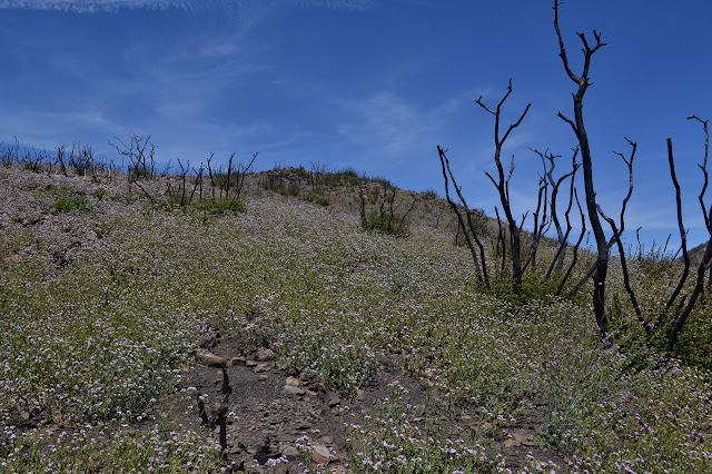
I take a good, long while at the top, but eventually start back. This time, noting a bit more of the vegetation. The yurba santa seems to be coming up in both a smooth version and a fuzzy version. Much of it is not yet big enough to have a bush structure instead of the stalks that poodle dog grows in, so the fuzzy one has me worried. Mostly, I just notice a lot of the purple phacelia. The giant phacelia that was all over at the other end of the upper north fork must not like to grow this high.

I note my footprints going down as I zip right past the turn off to get off the ridge and decide to have a look down from the little peak here to look down on Ortega Hill. Usually, I would climb the little one first because it just feels like more of an accomplishment at the top if I have not just been somewhere higher. Today I sort of just passed it by and later thought I might follow the ridge down to it. The ridge down from here is so full of sticks and rocks, it looks too annoying to do. From the pipeline on, it looks fine and I think I can pick out little bits of trail along it. It is hard to say. The one person who has written a trip report from the era when these peaks were on the Hundred Peaks List says they did them in a loop.

I figure it would actually be easier to drop all the way down to the trail and then climb up again, but... well, the ridge offers a different sort of hike. I head back on the trail I came up, but at the pipeline, climb again. Taking the pipeline haul road! It is a pretty easy trek, I just need to get off it before it wanders north on a ridge I am uninterested in. That is easy enough. There even seems to be remnant trail going up and over the bump where my path starts to differ. From there, it is a long downhill where I seem to need to head off to the south a bit from time to time. There is a very old fuel break, but it was not done during this last fire. The diagonal cuts to slow down water gushing down it are still obvious. Eventually I am almost as low as the trail.


There is a shallow depression at the bottom that would have been something to aim at had I gone along the trail. I am still along an old fuel break and hitting apparent remnants of trail as I climb upward. It is a very nice walk, as off trail peak bagging goes. The top is wide with only a gradual slope to help direct someone stuck in brush to the high point. It is a wonder those who came most recently were able to find the register. I walk over to a stack of rocks to... not find the register. There is a hole in the middle about register sized, but no register. I expected to find an extra rusty can with charcoal sheets held together by a spiral of wire. I did not expect nothing at all. These particular rocks are not even all that blackened compared to those nearby. I poke around the nearby outcrops, too, but there is nothing hidden within those either.


There is a spot of brush about 100 feet north of the top. Even getting through the sticks to get to it takes a little bit of work. Nothing is promising over there for a register either. I take a little time looking out over Matilija and nibbling before heading down. I am tempted to head back the way I came and then past the little dry depression. It would get me to the trail faster since it climbs along that way. Still, there seems to be a slight trail the other direction and so I go the way that should ultimately be shorter to drop down to trail very close to the road. From there, my route is certain and I just roll on down it back to the car.

©2018 Valerie Norton
Posted 12 June 2018
Liked this? Interesting? Click the three bars at the top left for the menu to read more or subscribe!


Comments
Eric
https://kg6mzs.com/sota-2/