Rocky Peak
Rocky Peak Park
Indian Springs Open Space
Click for map.
I am not entirely sure how it happened, but we finished planning the outing for yesterday with plans for today as well even though there was never any question as to where or when the other would be. It is a much smaller group today with just Scott, who was generally the instigator of plans, and Linda, who decided to hike just today. Linda brought along Milo, who should be good for sniffing out geocaches and better be a good hiker because we should come out around 10 miles again today. She says that he is. I joined up because this hike swings past Rocky Peak, which is on the Lower Peaks Committee list and has a county line marker up on top. It should be a little harder to get to than the one I nearly tripped over by Random No. 2, but a bit easier than the one up on top of Dome Mountain. Scott has been before, Linda seems so disinterested that she forgets a peak was mentioned within seconds. Milo seems ready to get to wherever is "ahead" first. Although where and how we will come out seems a bit of a mystery, we get the cars set up for a shuttle between the ends of the two motorways and start by the big, beautiful sign for Rocky Peak Park. Onward and upward and into the rocky.


We have plenty to do on the way up. It is not just the "treasure hunt" and signing of logs. There is also an earth cache to ponder and encourage closer examination of the general surroundings.


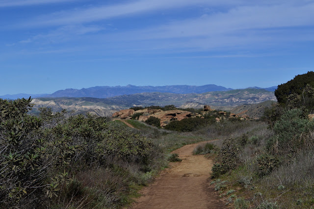


We get to a well worn trail that breaks off the side of the road and starts up a steep track along the ridge. Scott confirms that this is the trail to the peak. It comes back to the road further up, but my plan is to go out on a spur to it and I would rather use the other trail. I think it will be easier and it looked shorter on some map. After another episode of reminding Linda there is a peak and a discussion that I really do not want to use the steep path, we continue on.

As the motorway seems to top out, there is another well worn trail. Scott confirms that this is the other trail out to the peak. I am not at all surprised when we have to remind Linda that there exists a peak and I want to go up it. She thinks it is total nonsense and I still think it is the main reason I came on the hike. Lower Peaks Committee listed peak, county line benchmark, and even some geocaches to find. A total trifecta of reasons to go there. Oddly, it is not the geocaches but how obviously obsessed with the peak I am that seems to sway Linda into allowing this diversion. I was wrong about the trail on this side being shorter, but it is practically flat and therefore a lot easier.


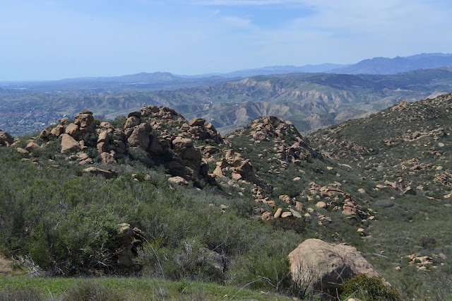
I know that somewhere along the way, there is a spur from this trail that roughly parallels the road below to the peak, but I am not sure where it might be. As the trail starts down steeply, I figure it must be before that and take a spur up to the top of a local peak between the trail and the high point. It gets to the top, but getting down the other side is a bit of a chore. There is a good trail only 40 feet below, so I take my time across some less slanted rocks and a dirt hill that is not too bad and land on it. Scott took Milo since he has been to the peak and a leashed dog may be a danger while scrambling over rocks. Linda starts down behind me, but then gives up. This is not entirely surprising to me. After vanishing for a moment, she comes back with a renewed determination and, slowly but steadily, joins me on the trail at the bottom. I guess we are doing this thing. We just have the one climb left; it really is not that long a spur. Trails braid on the way up the peak and initially easier leads to harder just to be contrary, but without too much ado we get to the top. We just have the summit block to navigate. I can see a way over the top of another rock and use it. At the top! Benchmark!


There is no way Linda is going to follow my route, but she does not have to. If she can get to the other side of a big bush south of the rock, she will have a nice walk a little further around and up the back side of it. She does this, but only because there is a virtual geocache that asks folks to view the county line benchmark. While there are plenty of people in this world who would look at a photo and say they had done it, we are normal people who realize that the only one we would be cheating is ourselves. I have to admit, I have never seen someone so utterly uninterested in being on a peak even while standing at the top of it on a day with a nice, clear view.

We head back on slightly better trail choices than we came up along. Keeping to the trail around the side of the intermediary peak brings us back to the trail roughly paralleling the road just a little way down its steep descent that I had dismissed out of hand as the wrong way.

We follow the nearly flat path back to the road and then follow its undulations until it dumps us out on Johnson Motorway.

Once we hit the other road, it is all downhill. Well, except for the small diversion to climb up into a cave on the side for a geocache. Scott goes low and I go high and my route works out, giving me the dubious honor of sliding along a ledge to get into the cave and sign the log. Linda, meanwhile, says she is getting vertigo just watching me do it. One begins to understand why peaks have become a no-go zone for her.


There does seem to be a moment, still, in which the peak is slightly interesting to her in reflection. Fears and worries are always easier to face when the outcome has already been determined to be survival. Meanwhile, as the afternoon gets late, they decide that we do not have any more time for geocaching except for one with a lot of favorite points. Scott points out that with 11 to go, that is nearly an hour just of signing. This rather succinctly describes why it can take so very long to go down a trail with a lot. I figure that means we still have plenty of light, but the others have a few duties that will not wait.

I seem to be determined to put a lie to my claim that the reason I came was to climb the peak because I seem to be the least satisfied with just letting the geocaches sit without even the slightest look. The one we are still going for is actually the one that will take the longest, but it has a lot of favorite points. It sits 400 feet off the side of the road with no way to get there from the close point. It was placed near an old ranch house that burned in the 1960s, so as we go a little further, there is a perfectly good road to access it. We take the time to look around. Got to remember that the priority is being there, not signing logs.

As we continue down, the dirt motorway drops into a gated community of rather large houses and outright mansions. It turns paved as we pass the first driveway. Fence on one side and guardrail with inconsistent ground behind it on the other force us to walk on the blacktop. Rather than point the way of the trail, there are just signs on the roads admonishing us not to go that way. As we meet up with the Santa Susana Pass Trail, there is a decomposed granite walkway for us to use. Milo rather likes the grass on the side and does seem ready for more miles, whatever they may be.

We are eventually dumped out of a pedestrian gate near the manned gatehouse with a last little bit of pavement to go to the parking under the freeway. I notice no marker at the gate for the trail. The final miles on the GPS are closer to 9 than 10.
*photo album*
©2018 Valerie Norton
Posted 24 Mar 2018
Liked this? Interesting? Click the three bars at the top left for the menu to read more or subscribe!


Comments