San Rafael: Upper Sisquoc
Los Padres National Forest
DAY 1 | DAY 2 | DAY 3 | DAY 4 | DAY 5 |
Click for map.
The night was not so bad as I feared it would be. There was a lot of room for it to be worse. As unprepared as I felt I was, I was mostly comfortable to be honest. There are ultralighters who probably think that means I have excessive gear. The wind could have easily challenged my setup and won during the night, but it stayed a breeze. We do not listen to that sort of person. While the emergency blanket probably kept in more moisture than it blocked, it also kept the wind from stealing my warmth. To show me just how bad having that warmth stolen is, my Platypus bags have a half inch shell of ice around the sides and my drinking tube is frozen quite solid. The first time I left it overnight in significantly freezing temperatures, I had the good sense to empty it first. For some reason I have not been able to remember to do so since then. The gloom and cold and threat of weather has not changed, so I experiment with just how much I can do still tightly tucked under my quilt. The pot lid is frozen onto my uneaten supper, so I put it on the stove and give it enough fuel to cook it (under usual circumstances) before nibbling at it again. My stomach accepts about 2/3 before getting a bit gurgly. The cooled remnants get stored away in the pudding container followed by the realization that I might have had some pudding first. Having a now clean pan means I can drink down some hot, sugary liquid instead.
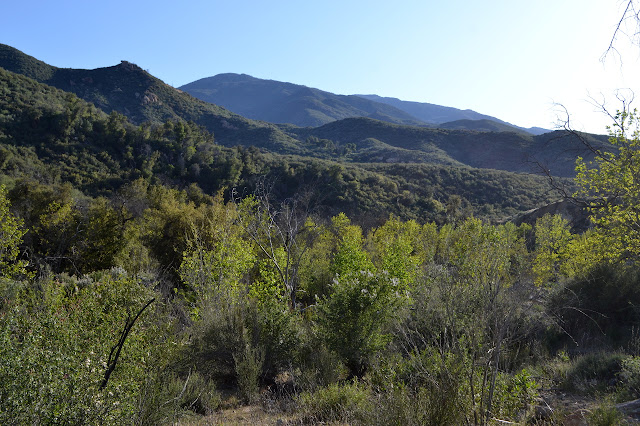
Now I have to decide if I really want to go up those mountains. I deeply suspect that it will be a visually stunning and cold day (followed by some more cloudy and wet as oscillation seems to be the established pattern of weather this year and the system will last until Friday) but very very cold. I just do not have the right gear for thrashing through the bush up Samon Peak in a cold wind. This really drives home the abuses I casually expect my rain or wind gear to go through. Instead, I could just head up and around missing the peaks. On the third hand, I could continue along the way I am going down to South Fork, which happens to be a descent day travel away and still have the old guard station. Ultimately, I decide to just go low and a little shorter miles. There are some aches and pains that are not vanishing with the evening rest the way I expect. The old cabin and original plan wins although I would have parked by NIRA if it was the plan when I started. I will just have to climb up Big Cone Spruce and down the road tomorrow. Decided, I put away my gear being careful with the emergency blanket that is likely to be needed again.

There are lots of logs to step over, ceanothus to wander through, and ribbons to make sure I know which opening to aim for. Coming to Bear Camp, AKA Lower Bear Camp, it looks like a death trap with the standing dead trees but it has a table. I am jealous.

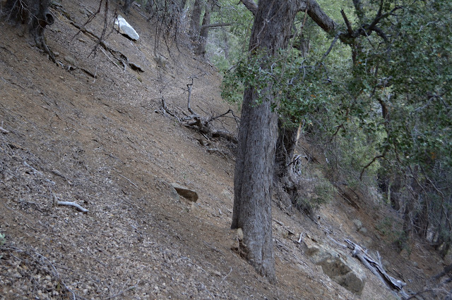
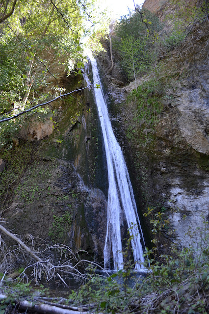
There is a little more burned meadow to deal with before the canyon changes character into a tight and steep, earthy and rocky canyon. Gradually, there starts to be waterfalls. The trail along the slopes is thin and scary at times. Meanwhile, that frozen water tube is still frozen and I am getting a little bit thirsty. But waterfalls! Getting a look at them is a bit of a challenge, but they are there.


There are so many waterfalls that I almost miss a larger one below while trying to figure out the best view of one above at one point. I expect a little more trails scampering down to try to get a better look, but maybe that is just a testament to the steepness of these canyon walls.


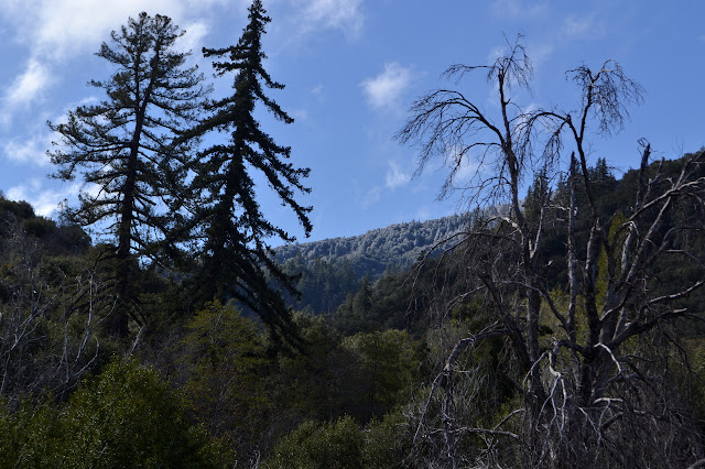
I find myself out on a thin wedge of land as a second creek, at least as big as the new river I am following, comes in from the left. The trail hugs the wedge as it makes its way down to the confluence and Lower Bear Camp, AKA Falls Camp. The last of the waterfalls is just above the camp and even this one is hard to find a good view point for. Below it, there are still lots of trees down although the fire scar is not so extreme. There are even a few jungle gyms and crawl unders. The crawl space next to the creek is, um, interesting. I pull a few small ones off the trail just because. One of them is even developing a walk around trail. People must be putting all their energy into hiking through here. Gradually, it clears off as expected. Just above where I camped, there is rather visual evidence of how cold it is. The pines are flocked with ice.
I stop suddenly just before yet another creek crossing where there is a stick freshly leafing out. Poison oak. The first I have seen coming down. The GPS puts my elevation at 4100 feet, maybe a little higher than I would expect. Whatever, it is time to start watching out for the stuff. There are nicer things too. Once clearing looks to be densely popping forth with the leaves of some kind of lily. I am certainly moving down into spring.


I arrive at Heath Camp at the junction with Judell Canyon to find there is a fire burning. Except for little bits of trash and a puddle of horse piss, some fresh road apples, the site is quite clean, but there are two big logs hanging over the side of the fire ring and flaming away. The creek is 100 feet away and someone could not be bothered to haul water all the way up here and put this out? It takes moment to realize that I do have a bucket of sorts to deal with this and drop my pack to extract the dirty water bag. Water poured over the large logs never quite seems to put them out. There is always a bit of a crackle from deep within the cracks that shelter the fire. There is so much heat left in the coals, I wonder if they even tried to put this out. I finally give up at getting the big logs out and resort to taking them to the creek where they join a third log that is suspiciously half burned. As it is getting toward lunch and my pack is already down and open, I finish off my supper and then mix up my missed breakfast before continuing on.


There are still a few downed trees as I continue on toward South Fork. The trail should become familiar once I get to Rattlesnake Falls, which I visited on a spur once. Things actually seem familiar a little earlier as I approach one part of the unsigned Cottonwood Camp. The fire ring has been turned into a table. There is a second site across the creek also without a sign. The canyons do have signs as though there are trails. Should I visit the falls again? It is a short way off the main trail. Of course I should visit. The horses before me also came up nearly to the pool.


Past the waterfall, it is definitely familiar territory. I do not remember any stream crossings, but I suspect that only means I kept my feet dry. There are certainly plenty of crossings now and they all seem familiar as I come to them. Sometimes requiring slight creativity, they are all dry foot crossings, too.


After a section hugging the river and crossing it at any excuse, the trail swings out high for a look at flats across the way. It is getting late, but my map promises me that there is one more crossing and then the station.

The first gate is open, but the second is latched. Someone changed out the wires on the gates since I cut myself on the barbs. They seem a little easier to latch again, too. The stock is here and quite friendly. They think I might have treats. One camper up from the trail work a little further down river and the folks to go with the stock mean it is positively crowded. Five people all in one big camp. There is one spot left in the cabin, so I can have that.

Oh, and we chat about fires. And when a big log goes on that will not finish for more than a day, we chat about fires again. "Was it really flaming?" As though I go around sticking my hand in every fire ring just to see if there might be a little heat there. Yes, it was really flaming. Two big logs with flame lapping around them. Seriously, those who make fires frequently seem to have a very lax approach to it borne of nothing bad happening. Yet. The thing is, usually nothing bad does happen. Campfires getting away is a rare event, there are just so many camp fires that this rare event happens many times each year. You have to stay vigilant in order to avoid becoming that guy who burned down the forest. Most times, folks are just lucky and they do not even understand that it has only been luck.
Continue on to the next day ⇒
©2018 Valerie Norton
Posted 25 Apr 2018
Liked this? Interesting? Click the three bars at the top left for the menu to read more or subscribe!


Comments