Posts

Showing posts from May, 2019

sketch

Image
Just one lonely sketch before a huge drought. Pondering the cuts in the cliff face while returning along the Gila River .

Ben Lilly memorial

Image
Gila National Forest Click for map. The stop is one I wouldn't know about except that there is a geocache to mention "the little trail" and OpenStreetMap marks the memorial. It looks like there may have one been a little parking beside a sign to alert drivers to the presence of something along this hairpin turn. Now there is a sign post and if you drive off the road beside it, even a high clearance may not do well. It is possible to park inside the hairpin, even with a low vehicle. After parking, I head to find the first of three geocaches in the area, utterly fail to find a second even after a lot of looking, then decide not to even go after a third because there's a whole lot more terrain between me and it than indicated on the crude elevation information also contained on my OpenStreetMap. My goodness, but there is a lot of terrain hidden from the road behind a few trees. Of course, none of these are on any sort of trail. Priorities. Somewhere near t

North Mesa from Middle Fork to East Fork Gila River

Image
Gila National Forest Click for map. I find myself in a state of waiting for a few more days and wanted another hike. I have gone into areas southeast as well as I can, northwest, and southwest leaving the northwest left to explore. I noted that if I head up the Middle Fork, there is quickly a trail heading out east over the North Mesa with a couple of possible routes to where the East Fork Gila River is not a collection of private property. It looks a little long, but measures about 18.7 miles. Probably will be 20 again if I go for a little bump labeled "Whiterocks" and a benchmark or two, so I tried for an early start. It's early enough at just after 8AM, especially for splashing through the river. Early enough starts are getting really easy with the lengthening days. Some of the Middle Fork Gila River that I missed out on when I took Little Bear Canyon to finish my backpacking trip. So down into the river canyon I go on some old road that vanishes in the

Little Creek and EE Canyon

Image
Gila National Forest Click for map. I decided to go on the EE Canyon Loop, except that's not long enough and there are a pair of trails along Little Creek and the ridge north of it (Ring Canyon Trail, but not named for that part) that have a few connecting trails to make a number of possible loop lengths. I settled on a connector only shown on OpenStreetMap, but it has been good to me so far and the Forest Service is definitely missing a number of trails on their maps. The trail start in Woody's Corral is easy to find. The trail at Woody's Corral is easy to find at the west end and from there, I just climb up. There is soon a sign pointing out destinations. I'm on Granny Mountain Trail, although it is first "Miller Springs" until it reaches those on the map. There is no junction here, but one arrow points off in another direction and as I look that way, there is a trail down in the sage on the river flood plain heading off to Gila Cliff Dwelli

Trail to the Past

Image
Gila National Forest Click for map. The little trail in Lower Scorpion Campground claims it will take you over seven hundred years into the past in a short quarter of a mile. It actually has two particularly short trails, a flat one that was once paved off to some pictographs and a work area, and a dirt one up the canyon to a small dwelling. The pictographs get the sunlight in the afternoon and the dwelling is situated to catch morning sun and afternoon shade. The sign and trail to start one off "to the past". I actually walked the trail a few times, usually first to the painting then to the dwelling. Timmy even walked it a couple times, faithfully following even without a leash. (I don't really trust him to stick around in case of animals, so he gets a leash on a real hike. If the trail were any longer, he would have gotten uncomfortable with the distance from his home base and turned around anyway.) He seemed to like the work area best. There are more p

High and Low on the Gila River: Middle Fork and Little Bear Canyon

Image
Gila National Forest DAY 1  |  DAY 2  |  DAY 3 Click for map. There is not the slightest hint of frost in the morning. It is much warmer down here than it was in the park. My shoes and socks aren't quite dry from yesterday and chilly to put on, but they'll get even wetter soon enough. I devour my breakfast a little easier than usual and pack it all up. With a quick look over to make sure the place is clean and nothing left, I turn to see exactly how soon. The sun is not even thinking of peeking over the top of the cliffs (besides, the sky seems a little overcast) at 7:11AM as a cliff ahead forces the trail across and I plunge into the water with almost no hesitation. The water is not bad, really. It's the evaporative cooling that starts as I step out that is annoying. Here endeth the walkable land, so either I stop here forever or I cross the little river. It is 3/4 of a mile before I get to a better camp site and just across the river is a particularly

High and Low on the Gila River: Prior Creek and Middle Fork

Image
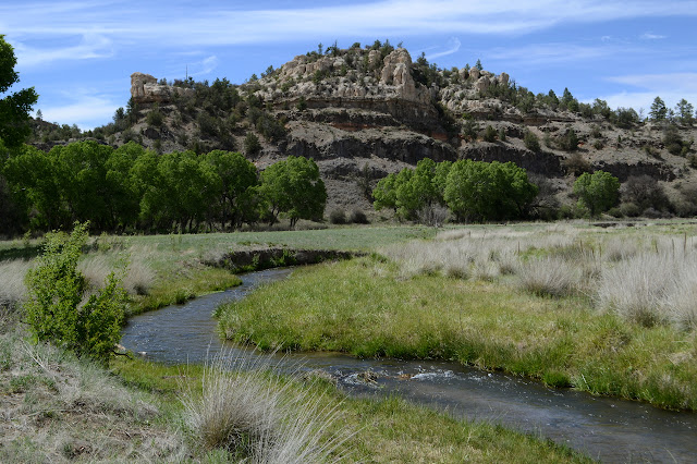
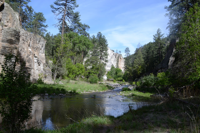
Gila National Forest DAY 1  |  DAY 2  |  DAY 3 Click for map. I can't help but notice the frost and just a little bit of freezing around my campsite. I am somehow still warm enough with just jacket and down booties to supplement the summer quilt. I don't really care to face that cold without my puffy pants, but I also want to hike until the GPS clocks another 20 miles, so out into it I must go. I fool a little with trying to keep warm with the quilt while moving about, but it is just too awkward. As long as I am sitting folded up, it is not too bad. Anyway, the sun is here and it will warm fast. Woodland Park Tank in the light. Some of the trail feels frozen as I start, but it is so close to the warm, shallow water of the tank that it must be my imagination. There is another skeleton like the last just off the trail. This one is a little more intact including two legs with two toes at the end. Okay, not a horse. It is not stocky enough for cow and the skull

High and Low on the Gila River: West Fork to Woodland Park

Image
Gila National Forest DAY 1  |  DAY 2  |  DAY 3 Click for map. My cat sitter reappeared from nowhere! Well, from Woody's Corral after some half completed communication. She said I can have another backpacking trip, but there is a deadline of 3PM on Sunday to complete it. If the communication had finished earlier, I might have had a week to play with, but so it goes. The weather seems to be changing and the predictions seem unbelievable. (The highs and lows are too close together to be real.) Last night was a lot warmer (56°F) than things have been, so I expect I don't need any puffy pants. I got packed and moved and my backpack packed and things charged and a plan sorted by 1PM, just an hour later than hoped, so now I am ready to head out of PJ Corral (about a quarter mile from Woody's) intending to finish some 40-45 miles in the next 50 hours. First up is the slightest taste of the West Fork, then climbing up to Grave Tank. The kiosk at PJ Corral warns tha

Down the Gila River stopping by Alum Camp

Image
Gila National Forest Click for map. Off the other direction from Grapevine Campground on a little spur of road is some day use only parking signed as a trailhead that does not appear on my Forest Service quad. What does appear is trail coming up the river just as far as a "spring (hot)" about two miles down. Besides the signs assuring me this is a trailhead, not just river access, there is not much indication as to where the trail goes. An information kiosk on the downstream side sits beside heavy trail to the water but nothing visible on the other side. Some trail wanders up a little to the confluence of east and west forks, but that way is private property. Asking OpenStreetMap for a second opinion indicates that not only is there trail here, but there is something too famous to bother to spell out: CDTGR. There are also a couple Continental Divide Trail through hikers splashing through one last crossing before heading up to Doc Campbell's, purveyors of homema

grave on East Fork Gila River

Image
Gila National Forest Click for map. There is quite a lot of private property along the East Fork of the Gila River with a road running through it all and trail #708 at the end of it going out to another clump of private property and some more trails that failed to get on the Forest Service map even though I know they exist. Well, the other end of the one that climbs up to Military Road by Thirtytwo Tank certainly exists and looks used. My guess would be I can walk that road, but the ranger I asked wouldn't say for certain then indicated he'd been around long enough that he should know. Sounds like, "Yes, but the landowners would rather it not be so and I have to deal with them more." The river is clearly navigable, so that definitely exists as a right of way. If I wanted to do a big loop including the area (which is very possible to do), I would pursue it more. Instead, I will just get a taste of the area by searching for a grave that is west of the private

SA Canyon

Image
Gila National Forest Click for map. If one travels all the way to the far end of Grapevine Campground (one of numerous free campgrounds in the area) without crossing the East Fork Gila River, there is a dreary looking little dry canyon that some local geocacher assures me will be a short hike to something great. Well, maybe not too dreary, but compared to the leafy green of Grapevine and the sedate but strong river flowing past, it doesn't seem to hold up. Numerous people logging it seem to agree, but for some reason the logs just stopped totally after the 7 finds in 2015. There does seem to be a very distinct trail into the canyon. It is decorated with toilet paper shoved under rocks, which seems like a very compounded error to me. They camped too far away from the toilets for them to walk all the way over there? Surely they knew how far they could walk. They can't use pits because it disturbs their delicate noses too much, so they wanted to spread it around more? So

The Military Road

Image
Gila National Forest Click for map. I'm getting antsy about getting in my long hike. The weather yesterday threatened terribly, but it looked like the folks who took horses out in it had nothing particularly long or hard to deal with. Today only has the slightest bits of threat here and there, so should be better. I'm taking my rain gear anyway: the old non-breathable coat and a cheap rain skirt I picked up and my tall gaiters. The breathable coat leaks, so it's out, but my legs are most sensitive to feeling clammy anyway. The skirt technically doesn't breath either, but it circulates instead. My shoes are just going to get wet if it rains. Extra wet with everything getting pushed down to them. Ah, misery. Maybe it'll stay a nice, blue sky. The Military Road goes between points on NM-15 and NM-35 by Roberts Lake. This end has a loop with an information kiosk on one end and a corral and short 4WD road at the other. I start off at the kiosk, which does

follow by email