High and Low on the Gila River: Prior Creek and Middle Fork
Gila National Forest
DAY 1 | DAY 2 | DAY 3
Click for map.
I can't help but notice the frost and just a little bit of freezing around my campsite. I am somehow still warm enough with just jacket and down booties to supplement the summer quilt. I don't really care to face that cold without my puffy pants, but I also want to hike until the GPS clocks another 20 miles, so out into it I must go. I fool a little with trying to keep warm with the quilt while moving about, but it is just too awkward. As long as I am sitting folded up, it is not too bad. Anyway, the sun is here and it will warm fast.
Some of the trail feels frozen as I start, but it is so close to the warm, shallow water of the tank that it must be my imagination. There is another skeleton like the last just off the trail. This one is a little more intact including two legs with two toes at the end. Okay, not a horse. It is not stocky enough for cow and the skull is too narrow. Elk, maybe? Really big elk.


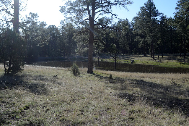
As the trail descends, it finds a few little rock structures to view. I quickly get to the next junction which was meant to be a decision point. If I am early enough, I can go along Prior Creek and down to a spot much further up the river. If not, I would turn for The Meadows and cut off about 5 miles of the loop. Of course, since I am just starting, I am early enough. There seems to be a bit of green by the creek as I get in sight of it. A little further and I can see that the "Trick Tank" marked on the map is a perfectly ordinary corrugated iron water tank. A little further and there is a cabin. It is signed as New Mexico Game and Fish and locked up night, but there is a well used campsite beside it and the thin running water of Prior Creek just a little further. Running water. This is what the folks not using the site at Woodland Park Tank knew that I didn't. There is a second site just up stream of the vanished corral marked on my map.

The trail junction at the cabin isn't marked, but a cairn shows where it crosses the creek and continues upstream. My route is downstream a short way, then leaving the water again. There are multiple trails that way, one actually in the creek. After the tank, only one continues. I cross the creek and ignore the fork of the trail that continues down it. Prior Creek empties into a high sided Chicken Coop Canyon that looks like it could be interesting, maybe that trail goes down and takes a look. I wander along hills into the upper part of the same canyon where a lichen encrusted sign points out the official trail that follows it upward. It is just a little canyon here, but it is muddy as I get to the bottom. One could get water here with a little work. Or could just wait for the water to come up on its own, I realize, as the trail follows the canyon a short way to pools and a brief flow. It vanishes again as the bed gets rocky. The trail turns up a tributary that is flowing, too, but is sucked into the ground just short of the dry confluence. Ah, the antics of water. It seems like quite a lot after all the dry stuff yesterday.

Then it is more hills, these a bit burned. I had wanted to go this way because it looked like it would get close to the top of the canyon for a while before dropping down along a ridge to a big bend in the river. Slowly, views down into the canyon do develop. Trees do tend to obscure these views, even in the burned area.


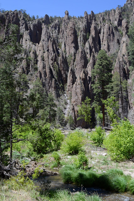
The trail does not get quite as close to the cliffs as I want for the views, so I follow my instinct for a little spur to the edge. The very high edge. I look down around a big curve to the brown water below and some caves across the way. It is quite a view.


I wonder if it wouldn't be easier for the trail to take the wide dip down to a spot just upstream rather than the little ridge line as it climbs slightly to pass between two large rocks. It is all downhill on a narrow track along short switchbacks after the rocks. The bottom is marked only with a cairn where the track curves to continue up the river. I guess I am just contrary as I turn down. I pause to eat (and get water, which is almost gone) to delay the first crossing, but eventually I must. It is splish-splash time and this time it is serious.


It's not really cold enough to delay getting wet. I actually stopped in the shade, not the sun. Don't think about it, just walk. I plunge in and my shoes resist the water for the slightest moment with a little annoying floating, and then it all comes in. This fork is also not particularly cold. It's a nice afternoon for a soggy walk and that's a good thing because these crossings are a lot more frequent than down after all the forks have joined.

At first, there are all sorts of things that look familiar but now seen from below instead of above. I can even pick out my perch to look out over the bend and confirm what I had suspected. It is just a little bit undercut like the rest of the visible edge.


Plunging through the water slows me down. I would splash and thrash greatly if I tried to swing my feet through it like through the air. Often I do not seem to find the same spots others are using and the rocks below are slick with moss, so I have to slow to find good steps as well. Still, I quickly get past the part of the canyon I looked down on and get new marvels.


I have barely seen any fish and those that I have seen were very small. Suddenly one crossing has a watcher in the form of a trout well over a foot long keeping still in the current. It isn't the only one. There are two more adjusting their positions to come over by the first. A fourth is satisfied where it is. All huge. I heard rumors, but was really starting to doubt. I watch them for a bit as the two adjust off again, then plunge in and the rest scatter.

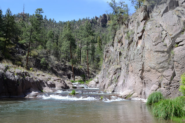
The crossings each have a character. Sandy ones are easy to find footing, but tend to introduce a bit of sand and small pebbles into my shoes. Trying to get the stuff back out of wet shoes is difficult and if I bother to stop for it, there is another sandy crossing 200 feet further on. Pebble crossings are nice with easy footing and less chance of new discomforts found in the exit. As the rocks get bigger, the footing is rougher, but not bad until the rocks start getting bigger than my feet. Once they are big, I have to pay attention to where my feet go down or they might slip out from under me. Now I have a new crossing type: slabs. It makes me rethink how cool it would be to check out "Slickrock Canyon". These rocks are slick and there is nothing within stepping distance to offer a little texture, so each step has a little unstable to its equilibrium. I have to walk very carefully staying perfectly balanced over my feet and watching out for spots where current or slant might push me along anyway. It works. Maybe it is not quite as delicate an operation as it feels like.


The trail tends to be on the inside of the curves and after a crossing it climbs up into the trees and shortens the curve a little. Cairns to make it easier to find the trail after crossing are often set up on my side for the other direction, but not on the far side. Surely this trail gets enough traffic that is not north bound CDT hikers taking the "Gila alternate" that both ways should be indicated? A few times, I spot a bit of trail the other direction has missed. Sometimes it isn't even clear why the other side misses it. Once, the trail climbs high for seemingly no reason and as I get down, there is a stagnant pool and cairns encouraging traffic on the other side to scamper along a thin bit of stones beside the river before crossing further up. I am on one of these semi-orphaned pieces of trail when it suddenly seems to fade. Further along, it is totally cut away by the river and past that there is nowhere on either side for the trail to go.

Should I continue up higher? I would be crossing over to a giant rock slide. Barely doable is my evaluation. The high ledge on one side has some footholes of sorts to get up to it. They are just a bit further apart than is comfortable to climb and then there is the question of getting down the other side. For that, there seems to be a slightly more difficult climb or a steep bit of dirt. At least across the rock themselves is easy. The river looks lovely along the way. It is many levels and each one has carved out a deep pool that comes up again to the next ledge. It looks like lovely little swimming holes except for the way the water seems to flow upward and outward at the top of each one. What comes up has to have gone down first. It is that subtle sign that doesn't seem so subtle once you know it is a strong undertow. But pretty to look at.


On I hike, the canyon changing in little ways and big ways. There is just so much to this canyon, and I can't even see half of it with all the trees. It does occur to me that I still haven't got to "The Meadows", which was only 4 miles away via the shorter route. For just 5 miles longer, this route is taking an awful lot of time.


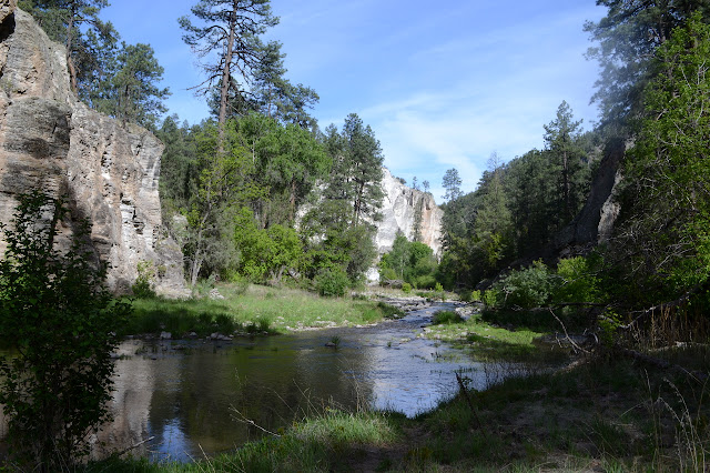
The Meadows do come with their junction, in among some large grassy spaces. The junction is even signed and has developed a boot that someone must have lost while wearing their river shoes. What confuses me is the pair of river shoes next to a fire ring apparently forgotten. Maybe that was someone who was taking the trail to Double Springs, which climbs up out of the canyon on this side of the river although I don't see it. I'm not sure if I get off trail or not as I make my way through the meadows. After a campsite, the trail gets thin and then swampy, but then there's a bit that looks built on a rocky slope and some cairns on the way back to the next river crossing. I'm glad for this crossing. At least I never come away muddy from the river.


There seems to have been some recent trail work, and now there are cairns to help folks going my direction find the trail on the far side of the river. It makes things go a little quicker without the pause and look step. As the day moves into evening, the light vanishes from the bottom of the canyon although the top is still bright. It is cooling, but not as cool as it will be in the morning, so I keep going. Besides, even with the extra from errors within the tall canyon, the GPS still hasn't clocked 20 miles for the day. I decide not to look for a campsite until after 7PM, then can't find any. There are some spots that might be workable, but I am not that desperate yet. I can use an already impacted site.


Finally there is a spot that I'm fairly certain might have a camp site and when I stand on tip toe to look over the green undergrowth, there is a ring and some space. It is returning to forest and the river is slightly noisier than some spots, but it is flat and open. It would be more flat and open without the fire ring in the middle, but this will work. I have found camp for the night. Just hope it isn't as cold tomorrow morning as it was today. I am here in the wrong season. Many of the trees appear to be walnuts, but they have no fruit at the moment. Tomorrow, I'm going the Little Bear route. There is no way I'm going all the way to the visitor center in the river. I've had enough of splish-splash time.
ON TO THE NEXT DAY
©2019 Valerie Norton
Written 6 Jun 2019
Liked this? Interesting? Click the three bars at the top left for the menu to read more or subscribe!


Comments