Dome Mountain - Goldfield Mountains high point
Tonto National Forest
Click for map.
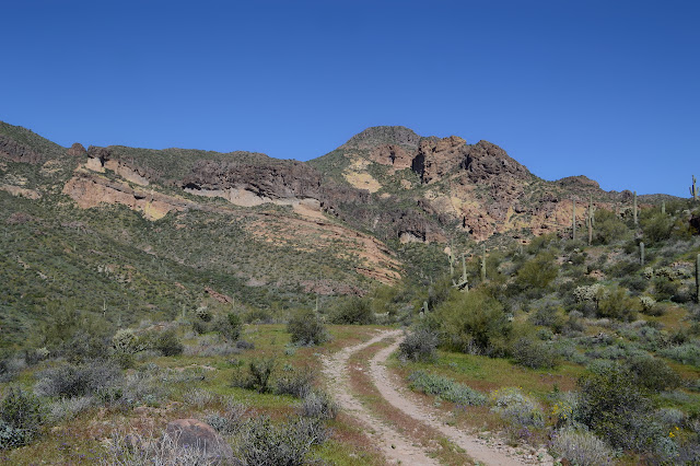
I don't want to neglect the Goldfield Mountains simply because they have not been designated wilderness. I can see approximately two named peaks in an area that should have a lot more, so it looks like they have been neglected enough. There is one showing many layers that has caught my eye. It gets the sun long before a lot of what is east of it, so it must be quite high up. I want to go up that one. Maybe it is Dome Mountain, the high point of the Goldfields. It doesn't seem to be in quite the right direction, but I'll go for that one. If it's the one, great. If not, I'll still be on a worthy peak. To enter the area with a vehicle, one needs to pick up a free Bulldog Canyon permit from the Mesa Ranger Station, but since this is a 4WD area, I'll just use one of the many parking spaces outside the gate and walk in.

The road on the far side of the gate is actually better than the little bit up to the parking area and I am a little disappointed that I did not go ahead and get a permit. That only lasts about a quarter of a mile before it roughens up and starts gaining sandy spots. I probably could drive it, it just wouldn't be good judgment to try. Travel is supposed to be restricted to marked routes, but there are more than enough random illegal roads to get lost in for a while. The main route seems to correspond with my route. Traffic isn't bad. Besides the guy battling the combination lock when I started, there hasn't been anyone.

There is a spot that looks like a parking area by a road that appears to be marked not for any vehicles. That one is my route to get up close to the mountain. Sometimes I hear someone driving around to the south, but there is still no traffic around me as I drift up the road.


There is a cairn with a trail beside the road as it starts downward. I figure it must just go up the nearby peak. The road starts down this hill into the canyon and there is a turn around. A little continues on before ending in a slide to the bottom. There is more trail and cairns at the end. The one at the top did not look well used, but these are even more overgrown. There is more stuff down in the canyon to contribute to the overgrowth. It isn't really possible to follow these cairns and there seem to be a few sets with their own ideas anyway, so I just pick out a route and start making my way along it, trying not to get into growth that is too thick.


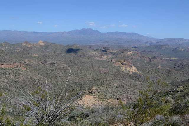
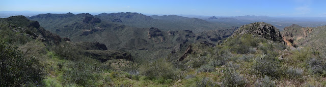
My original plan for a route was to get to the saddle east of the peak and push up from there. As I get a good look over the terrain on the lesser peak, I am suspicious that that is exactly what that trail up high does. I don't seem to be getting quite that far north. Down in the canyon, I'm really feeling my way up more than planning my way. While there are cliffs all over the place, they aren't a problem for going up. A route pushing down would be likely to end in a cliff, but pushing upward one just slides to the side and there's a ramp instead. With all the brush, motion is incredibly slow. Actually, there is getting to be way too much plant matter on this side of the canyon and a couple cairns on the far side where the green is much less dense make me decide to backtrack a short way and head across. Now it is getting even slower, but I am not worried. Then again, maybe I should go back and try that high trail instead. Still, I have more than enough water and time. Also, the canyon is absolutely incredible.


I do find myself going ahead and climbing up in one spot. It's just easier than dealing with the vegetation and the rocks are only a little bit crumbly. The easy way seems to be keeping high on the right as I go, then start to think I might be staying a little bit too high. It does slope ever more steeply the further up the right I go, but it keeps me above some of the interesting texture that might be hard to navigate.


My very slow progress up the canyon is getting easier as the land beneath my feet gets less sloped. I am out of the canyon and onto a gentle ridge with new views out to the west and just a little further to climb to the peak. And my stick is about two inches from a snake. Again. It looks so much like that last one, except the tail is just a tail. The head is not three times as wide as seems natural. It is just a gopher snake, which doesn't make the brief terror any easier to recover from. I give it a wide breadth too. No need to be rude just because it hasn't got a deadly bite. Then upward once again.


The last bit to the top is uneventful. There is an old register in need of some care and a new one in a clear plastic that won't last many years getting blasted by the sun. I still want to go back via the trail, if there is one, so wander along eastward to try to find it. Nothing there but a rugged country that looks like it might have been hard to navigate up to the peak. I can, however, see trail up the other peak. So it does do that after all.


So I go back to the top to enjoy the height, ponder what a brief sound of feet slipping on gravel might mean, then get startled ten minutes later when someone pops up the south side of the peak even though no one has signed the new register since it was set a couple weeks ago. Admittedly, this fellow doesn't bother to sign it either, so that's hardly indicative. He assures me that there is a trail, I'm just looking in the wrong place. Someone has even gone and painted white lines on it although it is only slightly dim. It was added to Alltrails five months ago and everything. (When I look, it is approximately the 80th listing as I page through "nearby trails" while standing on it. Ooh, wind caves. I need to get an income so I don't think $7 plus gas is just too much to spend. Getting distracted now.) So now I have an easier way down, I hope.

I start down the obviously unofficial trail and quickly figure out why I heard slipping on gravel. There are some spots where the footing is decidedly slick with rock marbles on top. I never had this bad footing on my way up. This trail is generally steeper, too, except for that one climb spot.

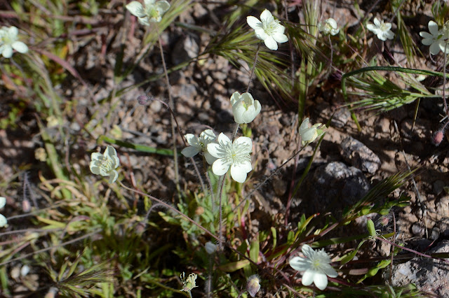
The trail takes advantage of the pinnacles for a bit of shade. In one spot, there's even a bunch of ferns. There are a couple spots where it is hard to find as it goes across rocks, but guessing where it might go is pretty successful.


It is still early as I get to the saddle, so I decide to go for the other peak too. It looks like a nicer trail although turns out to be hard to find briefly as it leaves the saddle and has more grass attempting to overgrow it.

The climb to the top is much easier, but it is much shorter. Still a nice little peak with a tiny little register. There is some reference to these peaks as "three lesser peaks". There is even a track uploaded to peakbagger that does a nice, big loop to grab them all and then return to roads via a horse trail. I'm not sure I have the time for quite all that, so will be satisfied to with just this highest of the three.

Then I'm back to following the trail down to the old road below. The folks who set this trail out to the the saddle and up the lesser peak used cairns to mark it, but the painter has been dashing this bit too. The cairns are enough, including to see where it splits and climbs again. I'm not sure where it might be going. Maybe another route up. I go with the bit of trail going down to get back to the road at the turnaround. That's odd. That's actually a little further along than the one I spotted on the way in. Maybe the other branch finishes slightly higher.


I take a moment to stop at the top of the little hill with road up it, then continue on down the road. The geocachers lead me a little astray which leads to an alternate route via a horse trail. There really are a lot of horse trails about. There are a few nearby ranches that advertise rides as well as a few wild ones running about.

The trail is nice while it lasts, but just over the ridge it dumps into an illegal road that seems to be trying for as much up and down as possible on the side of a tiny hill. This dumps me into the heart of random roads going everywhere and makes it a little hard to sort out which road I want to get out on. I think I missed it as I walk through a camp getting set up. It is Friday evening now, so a bit more crowded. It all gets me back eventually.

©2019 Valerie Norton
Written 4 April 2019
Liked this? Interesting? Click the three bars at the top left for the menu to read more or subscribe!


Comments
Going to be out exploring for sure! :)