Ryan Creek and Slough
McKay Community Forest
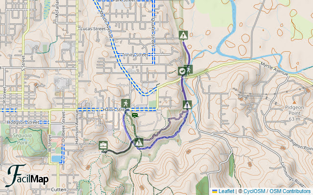
I wanted to have a hike in the McKay Community Forest focusing on those pieces that are actually within it at the north end. There would be no crossing over the creek to the easements on the McKay Tract. There would be an attempt to follow routes all the way to Park Street along the far north sliver of forest north of Myrtle Avenue. Most enjoyably, there would be wanderings of the trail system that's marked and somewhat rocked under the trees wrapping around the Redwood Acres Fairgrounds. There might be a jaunt off along the other edge to a geocache that had given me troubles before.

Parking for north end of the forest is simply parallel along the side of Harris Street. There's thoughts of a lot at the fairgrounds, but that has not been secured yet. My plan was to start along the old roads, following the R-line to R-2, then continue beside the creek as it becomes tidal.


As I was pondering one of the prettiest pockets of forest about, which pops up on the private property side after the rough fences of back yards retreat, I found some more of those "timber harvest boundary" flags that were lining the first part of the hike I just took in McKinleyville. People don't realize that the land around Redwood Fields actually belongs to a developer and this pocket north of it still belongs to Green Diamond.

I got to the first intersection and its gate, which is very secured against motorcycles leaving walkers to crawl through it. From there, the walk is sort of beside Ryan Creek. A second gate on R-1 has a nice little walk around.


I made a recording of the birds along this section. There's also a few squeaks from the redwoods in the breeze, especially toward the end.


A path diverged from the old road to follow on the outside of the trees beside a large meadow and I let it pull me from the main track.


My alternate path got a little scruffy right before rejoining the main route. North along the side of the creek continued pleasantly.


Arriving where both rocked trail and general use climb the hill into the forest, it looked like someone might be trying to discourage me from continuing north along the old road. Upon inspection, it was just a warning that there would be work on the 60kV electrical lines over a year ago. It may as well have said, "Turn back, all ye who be sensible!" for I quickly had to accept soggy, muddy feet. At least the road area is clear of anything more than buttercups and larkspur? water leaf? that hide how much water I'm about to step in but provide no other nuisance.


There is a plan for trail here eventually. It just needs a 200 foot retaining wall built near the bridge and more research for how trail will affect the gas transmission line hidden underground. Any of that will happen after the trails around Redwood Acres are finished. For now, it at least dries out a bit for the second half.


I found plenty of room to continue under the bridge to the northern section of the forest. A scrambling path gets up to the service road that comes off Myrtle and the gate leaves room for walkers to shuffle past. Then I found that, strictly speaking, it isn't forest. It's quite a nice view instead.


After the road ends at its purpose, there's a pretty good trail for a little bit. Apparently that one has a purpose too: accessing a bird house or two. After the last of them, it got scruffy with a few blackberries reaching across. Soon it just dropped into a watery channel and ended. I wasn't feeling much desire to try walking the channel. Another branch slipped along beside the fence shortly before becoming bramble. I wasn't feeling like pushing through that or trespassing either.


So, still 0.4 miles from Park Street, my goal was blocked. Park Street is not yet connected to the rest of the forest.


A fire truck had taken up residence in a turnout on the far side of the bridge and a diver had a pickup on my side and a boat had appeared tied to the pilings and, oh, it's a manikin. More cars were arriving and they were getting set up for some exercise. I didn't stay to find out what all they would get up to. I've seen them dangling from the bridge by the highway before, so it might have been quite interesting.


I came upon the section of trail that was worked by the monthly volunteers in February. It's kind of a steep, wiggly spot.

It was a big group in February, so I chose to pluck ivy rather than compete for work space with the rocking then. I stopped to check on a hillside I'd cleared. The wild ginger that also lives there doesn't seem to have filled it in much yet. I made sure the pile of invasive wasn't taking root, then checked on an area that had turned out to be full of blooming fetid adderstongue once the strands of ivy moving all through the ferns were removed.


I had the time, so I turned down the trail to follow R-1 a little way to find the pesky geocache hidden away there.

And after a good, long look and a huge hint, I actually found it this time. The difficulty is severely underrated as the hard side of easy (2.5) in my opinion. I headed back up from the road and into the higher trails again.

Much of the trail is nice up there even without rocks, but where it gets into flat areas, it is a mud puddle mess, widening and encouraging ever more area to be stomped. Work on the schedule of volunteers takes a while.


*photo album*
©2024 Valerie Norton
Written 28 Mar 2024
Liked this? Interesting? Click the three bars at the top left for the menu to read more or subscribe!


Comments