Hole-in-the-Wall: Rings Loop and Barber Peak Loop
Mojave National Preserve
Click for map.
The Hole-in-the-Wall visitor center for the Mojave National Preserve has a little notoriety to its local trails because one is set with rings to help travelers traverse a couple spots that otherwise would be somewhat difficult climbs. There are two loops possible to combine with the short rings loop, one to the south known as the Rings Loop is about a mile, one to the north known as the Barber Peak Loop is about six miles. The Rings Loop heads out from the south side of a parking lot near the visitor center and returns through the Hole to a picnic area on the same spur road but past the visitor center. There is a sign to show the start. This sign also explains the trail markings that are put up frequently along the route to that it is more easily distinguished from washes, cow trails, random abundances of human footprints off trail, and whatever else might exist to get folks lost.


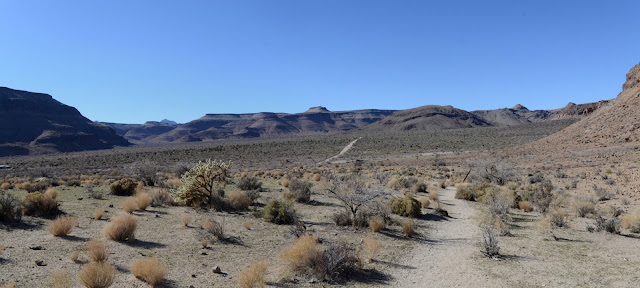
The trail navigates to the side of a couple washes and already it is easy to wander off in the wrong direction if not looking for signs. Ultimately, it just follows a rather flat route around the base of the mountain that happens to have a slot through it that is the hole-in-the-wall. As I get a bit further off into a wash that was not meant to be followed down the middle so much as down the side, I notice an information sign that also serves to show where the trail is. This one happens to shout out some petroglyphs that can be found on a few of the local rocks.


I round the corner into another valley with more peaks. In this area, footprints are everywhere, so they can not be relied upon to be on trail, but the markers persist enough to find the correct way.
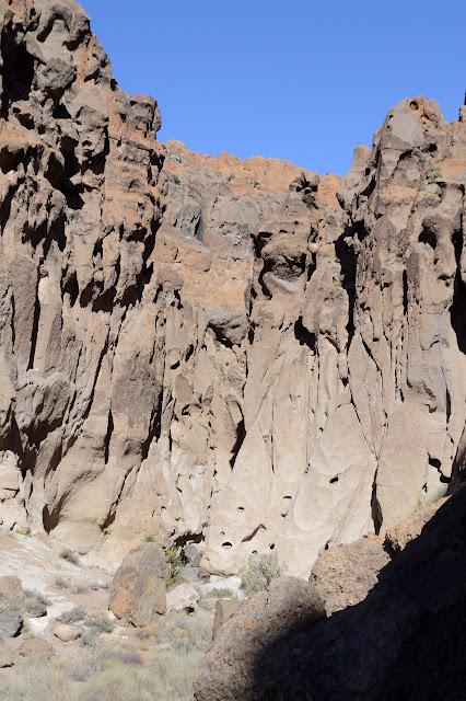
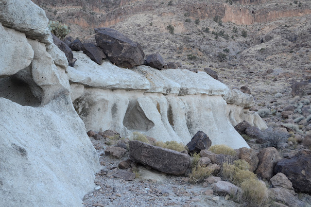
The trail curves around further and what was a few caves along the side becomes lots and lots of holes that are, in fact, in the walls. The rocks around the holes also take on interesting shapes.


There is a sign for the junction when the two loops combine to funnel into the Hole-in-the-Wall. Here, the trail starts a little climbing and there are sometimes big steps up rocks. It is all well worn with feet.

There is a split in the trail and it follows into slots on both the left and right. A sign seems to indicate the left is the correct way, but the right has quite a lot of traffic too. I go left.

This brings me to more stone steps that must be climbed and finally to the rings. On the way, there is an interesting line of what looks to my eye to be sedimentary rock in a few very light and very dark layers that separate the thick layers of ash that make up most the canyon.


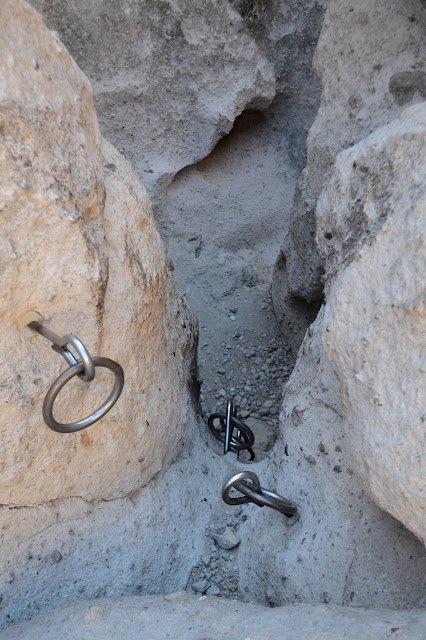
I find the rings to be a little difficult, partly because I am wearing gloves, but partly because they just wobble around a bit. I prefer the supports for a climbing aid. Shortly after, I find myself at the picnic area. Plenty of people are just doing the rings and none of the loops. I stop by the observation point before heading back to finish the loop around the mountain on the Barber Peak Loop.

The rings are a lot easier going down, but there are some spots when it might have been hard to find the next one down had I not come up that way. In short order, I am out in the sun again and following little trail marker signs while cows and people try to lead me astray. In fact, I have to pass by some cattle, both steers and cows, to continue on the trail. There does not look like much to eat out here, but they seem to be finding it.


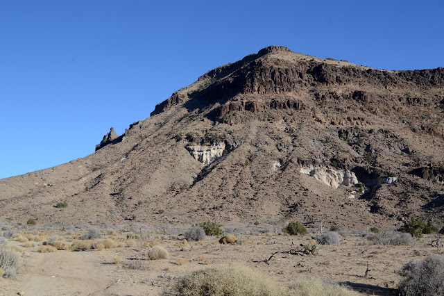
The trail starts to climb as it leaves Hole-in-the-Wall behind. Up ahead, the land is rather rough looking, but with plenty of opportunity for a trail to pass. The cactuses just look more and more like a garden with just a few types selected and all planted at a specific spacing. The mountain I am circling to my right keeps having strange and interesting structures, too. Well, so do the other mountains, but they are further away and harder to see.


The trail had seemed to be climbing to a pass between valleys, but it is quickly apparent that there actually is a canyon running between the two wide washes. As the trail sets down in the upper wash, I just have to go back and look at what was bypassed.

Narrow canyon and ledges greet me. As I look over the top ledge, it is clear it is concrete. Some ten feet below, a massive pipe with a massive valve sits waiting for a connection. I wonder if it was meant as a dam. Probably. It is completely filled with sand now. Continuing on, the trail sort of follows the wash still upward. Sometimes I miss where it gets out, sometimes not, but it never matters.

Except for the stark band of white, the landscape seems a little more plain for a bit. There are some interesting towers, but largely the mountain is getting more mundane. Maybe I am just getting used to the structures. I almost walk past a prospect without noticing. Well, it is really just a small hole in the ground now.
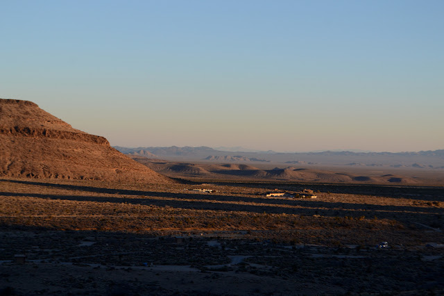
Rounding the mountain a little further, Woods Mountains come back into view. The wind has been blowing against me all the while I have been climbing, but the climbing keeps me warm against it. Now I will be moving into the shadow of the mountain and going downhill with a cold wind rushing past somewhat bitterly. It might be hard to stay warm enough for a bit.

The trail is distinctly marked specifically for the other direction as I head back toward the visitor center. There is more cattle, too, but it is suddenly apparent that there is water for them over here, too. For a moment of interest, the trail gets up close and personal with one of those white bands so I can get a closer look.
Over the top, there is a fence to keep the cows from the campground and visitor center areas. Past it the trail takes a turn for the campground and I somehow fail to notice that it also continues on up high before taking the extra trip down the spur. The rocks above are full of holes again. The trail is a mess and trying to follow it down takes a lot of guessing. It is probably because this is close enough to the trailhead that people come up and do a lot of wandering before heading back to their cars. The result is that everything looks like trail. The signs sometimes help, but they still seem not to be placed for best visibility in this direction.

I arrive back only a little bit bitterly cold. The wind really is a bit much and expected to go on for a couple more days.
©2019 Valerie Norton
Written 6 January 2019
Liked this? Interesting? Click the three bars at the top left for the menu to read more or subscribe!


Comments
(I've been to one spot in eastern Washington where there's a really thick layer of pumice & ash from Mazama, the eruption that eventually sculpted out Crater Lake...)