Telegraph Pass
Yuma BLM
Click for map.
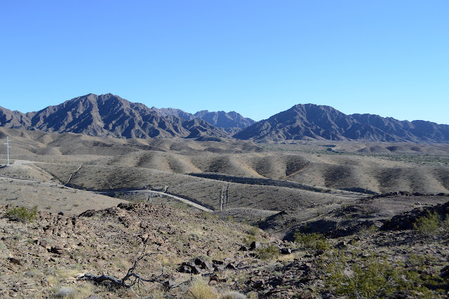
I checked out the Pioneer Cemetery in Yuma in the morning and did a few chores, then arrived at the trailhead for Telegraph Pass in the early afternoon with my outdoor thermometer reading 83°F. Hum, is that something I want to do? Intel on the ground (that is, by asking random passers by from Oregon who had just hiked it) is that it's only about a mile of flat and then a mile of like 40% grade on paving. Oh, and there are Gila monsters. I've never seen Gila monsters! He walked it back to big lizards about so long with ringed tails. This I'm not less excited about. I've seen lizards about so long before. But it sounds easy enough for the afternoon. I do want to go ahead and get the geocaches along the way, which seem to generally be rated on the difficult side, so that'll give me some moments to sit and sign and take a breather in the steep portion. So onward, but with quite a lot of water.

A sign at the starts tells me I could come out on April 6th to see how many times I can do Telegraph in a 24 hour period. No entry fee, no prizes, just bragging rights, and it's this hot a month before. I'm thinking nope as I follow the trail along the wash, finding out that the first two geocaches are a fair way up the side of the wash instead. So that slows me down a bit. Having coordinates substantially off from the location does, too. There's a section corner in the wash. I forgot to check for them, but it is easy enough I didn't have to.

There seem to be a lot of different ways up. With so many people, many who look like this is part of their regular routine, it is no surprise. I stick to what appears to be the main one, except for a few excursions.


The trail drops down, via about three different routes, to a road that includes sponsored port-a-potties. Past them is a BLM sign that includes some information about flora and fauna in the area as well as an invite to a guided hike about 2 years ago. The lizards could be the common chuckwalla, which look to be quite chubby things compared to those fence lizards I usually see. Common they may be, but I would be excited to see one. Also, it looks to be the end of the flatter section which wasn't totally flat after all.

They take my picture as I cross the gate and take it again in the same direction as I realize the geocache was actually off down a different wash, go around the camera to get it, then pass the camera again. That'll make them wonder. And then it is up. Is it a 40% grade? Well, probably not, but it is a bit steeper than roads usually climb.

Scrambling on the steep hill sides where there are a couple of caches takes quite a while and the caches seem to actually be hard to find. Or maybe I'm just having a bad day of it. One eludes me for almost half an hour before I notice it is actually supposed to be quite large, which somehow leads me right to it. It is getting quite late by the time I get to the top.


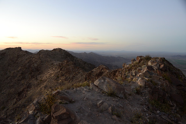
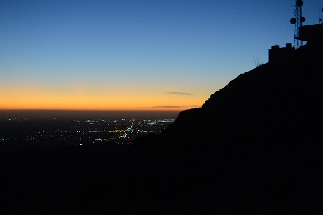
The trail is a lot easier to find as it reaches the road again. There are actually two spots to catch it. One is beside a bench that happens to have journals that serve as a register. Further up, a sign warns that electromagnetic radiation may be higher than is deemed safe for humans beyond it. Otherwise, the way is clear to just wander along the ridge toward the high point among the antennas. Hey, they've got my picture. Twice.


The sun sets as I make my way. While the high point among the antennas is marked "Telegraph Pass" on peakbagger, it is not actually the high point on the ridge. That is another 1000 feet along, as a crow flies. I am not a crow. I would have to travel along the ridge. The rather narrow and scrambly ridge. It seems a little bit far to be going on an unfamiliar ridge entirely after sunset. And I actually had thoughts of following that ridge around back to the start.
So I turn back, on the road. Not even on that trail I saw. I'm not too far behind the last. But you know what? I think I'll just do it again tomorrow, but this time better. Much better.
©2019 Valerie Norton
Written 5 March 2019
Liked this? Interesting? Click the three bars at the top left for the menu to read more or subscribe!


Comments