Ash Spring
Coronado National Forest
Click for map.
The loop, generally on the Basin Trail, past Ash Spring seems like a good one to try to get Timmy more familiar with being on trail. It is just three miles long with the spring about halfway with a nearby apple tree for taking a long rest, perhaps. Maybe a nice middle of the day nap is what he needs to keep going. (Odd, what things can be found marked on OpenStreetMap. There seems to be another apple tree on the South Fork Trail at the spot it gets bad.) There are two lots at Herb Martyr with trail parking above and walk-in campground parking below. Currently it is officially dispersed camping, but there are still tables and a toilet for anyone to use.
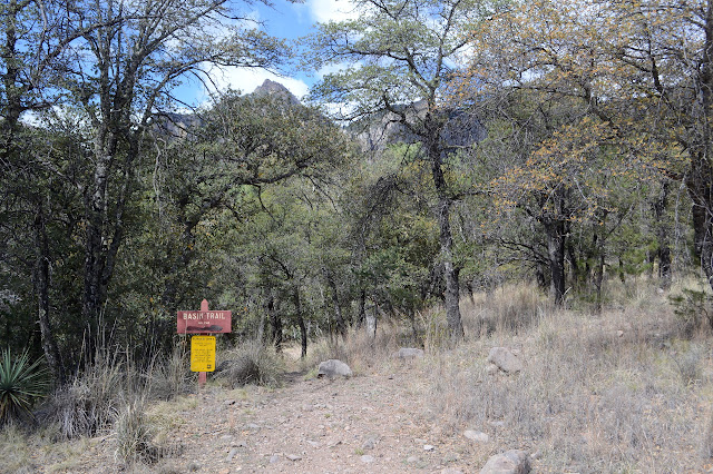
I start down the trail, which winds around the far side of the camping area across one old foundation and down a set of stone steps to Cima Creek below. It has good flow and a log bridge a short way up. It looks like a comfortable enough crossing, but does get a little less so while holding a cat who is not so keen on being carried. On the far side he is difficult because there are many patches on the ground that apparently smell extremely interesting to the point of actually tasting the dirt. One spot has ants also taking an interest. There must be something actually there, but it is not something that I can sense. The trail is also difficult as it crosses the flood area of the creek and gets lost in the rocks. Eventually I spot a small "trail" sign and get far enough downstream to come to a large sign. A very large path leads far more directly to it from the lower lot with a nice rock hopping crossing of the creek.


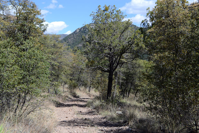
The trail follows near to Cave Creek among the alligator juniper with its distinct bark and the silver oaks with leaves dropping and budding. There are only little glimpses of the canyon and its impressive rock outcrops on the way to the junction with the actual Basin Trail.

The signs at the trail say it is 1/4 mile to Herb Martyr Dam back the way I came or 2.5 miles if I take a right. Luckily that is just the way I want to go. The trail climbs back over toward Cima Creek gaining slightly better glimpses of the surrounding canyon as it goes. A mystery gate, possibly marking the wilderness boundary, includes the first look at Winn Falls. It is an impressive waterfall way up there. A little further is halfway to the spring, so Timmy can have his first rest. He seems to live in hope that the food and water will stick around for a while, but can be encouraged to eat and drink.


A little bit further, and the glimpses actually start to turn into views. Real views! I can see way up the canyon. Timmy, on the other hand, has not found anything anywhere near as interesting as the indistinguishable (to me) spots along that first bit of trail.

Then it all drops down to cross Cima Creek where the Forest Service marks "Ash Spring" on their quad. OpenStreetMap also shows a blue dot, so I go looking for it. After a lot of wandering over a rather flat area, it is clear there is no spring there. Maybe there was. There is a second blue done on OpenStreetMap further on, so onward with us as well. Through another mystery gate, this one marked with a "US" in a diamond, and we get to the real Ash Spring. Holes have been dug below it so the water can pool and there is a fair bit of fencing. A trail comes up to here from below and there is a collapsing wood shack a short way along it. A little further, there is a scattering of cinder blocks and metal appliances where there was once a larger (and should have been sturdier) building. A little below that is the apple tree looking thin and gnarled and tortured and in delightful bloom. Okay, good place to rest and draw.


Timmy got himself a little nap after a very long wait. I doubt it was enough. The grumpy old boy probably needs hours. The trail leading down from the spring is a more direct route back and requires only the smallest bit of road walking, but it wasn't the plan. Also, it seems steep and sketchy here at the top as it passes even more fences and the edge of a dirt ravine. I head back up past the shack and Timmy actually takes some interest in that as we pass. Too late now! Also, it looks like what's still standing is ready to fall in on itself and I'm not going anywhere near it. He's walking along better now and the views keep getting better and if I reach down and touch him when I stop for a picture, he starts to get it that I am stopped. Another touch as I start again and he moves along some more. The trouble is, the afternoon sun seems to be a little hot for the fellow in the fur coat.


We make it to the road with quite a lot of carrying, much of it without struggle. The walking well didn't last all that long in the afternoon heat. The carrying is probably a mite warm for the little guy too. It is about the halfway point, so he gets another food and water break in the shade even if he wasn't working all that much. The road to Greenhouse Trail gets so little use that there is a distinct footpath forming along it. There is a campsite toward the start and then a ranch gate that somehow has not been plowed through by some vehicle even though nothing hangs from it to alert drivers to its unexpected presence. The hiker side of the gate isn't too bad, but ranch gates are always annoying.
The main road to Herb Martyr is a different matter entirely. It is smooth and wide enough for two way traffic to pass comfortably and we get to experience multiple examples of that traffic. What does the guy with the ATV think he is playing at? The road splits into one way routes and halfway along the right side is what looks like a pullout at first, but I am keeping an eye out for the other end of that trail that trail that comes down from the spring. With close study through the grasses and brush, I can just see the small signs indicating trail. So that is where it comes down.
It was quite a nice loop loop, but it is bugging me that I still have not found this Herb Martyr Dam that was supposed to be back the way I had come at the second direction sign. Timmy can rest since he won't care, but I go poking around the campground just a little bit more to find it a tiny bit downstream of the parking lot. Finally.


Finally satisfied, I can join the cat resting. It took us just six hours to do the three miles. That really is a bit much, particularly when it is generally good trail.
©2019 Valerie Norton
Written 28 April 2019
Liked this? Interesting? Click the three bars at the top left for the menu to read more or subscribe!


Comments